Forest Hill railway station

Last updated

Forest Hill Overground roundel (no text).svg National Rail logo.svg
Forest Hill Station - geograph.org.uk - 1930361.jpg
Greater London UK location map 2.svg
Red pog.svg
Forest Hill
Location of Forest Hill in Greater London
Location Forest Hill
Local authority London Borough of Lewisham
Managed by London Overground
Owner Network Rail
Station codeFOH
DfT category C2
Number of platforms2
AccessibleYes
Fare zone 3
National Rail annual entry and exit
2018–19Increase2.svg 5.292 million [1]
2019–20Decrease2.svg 5.000 million [1]
2020–21Decrease2.svg 1.322 million [1]
2021–22Increase2.svg 2.947 million [1]
2022–23Increase2.svg 3.757 million [1]
Key dates
5 June 1839Opened as Dartmouth Arms
1845Renamed Forest Hill
Other information
External links
WGS84 51°26′20″N0°03′11″W / 51.439°N 0.053°W / 51.439; -0.053
Underground sign at Westminster.jpg  London transportportal

Forest Hill railway station serves Forest Hill in the London Borough of Lewisham, south London. The station adjoins a road which serves as part of the A205 South Circular Road.

Contents

The station is managed by London Overground, with Overground and Southern trains serving the station. Thameslink services also pass through the station. It is 5 miles 50  chains (5.63 miles, 9.05 km) down the line from London Bridge, between Honor Oak Park and Sydenham, in Travelcard Zone 3. There are four tracks through the station, although only the slow lines (the two outer tracks) have platforms.

There are two entrances, the main one being on platform 1 at the bottom of the South Circular Road, and a side entrance on platform 2 on Perry Vale. The ticket office is placed in the main entrance, although there are ticket machines outside both entrances.

History

The station was opened by the original London & Croydon Railway (L&CR) on 5 June 1839, as Dartmouth Arms (the name of the local inn).

The line was also used by the London and Brighton Railway from 1841 and the South Eastern Railway (SER) from 1842. In 1844, the station was chosen by the L&CR as the northern terminus for Phase 1 of an experimental atmospheric railway to West Croydon. A pumping station was also constructed at the station. [2] The L&CR and the L&BR merged to form the London Brighton and South Coast Railway (LB&SCR) in July 1846; the following year "atmospheric" working was abandoned. In 1845 the station became Forest Hill for Lordship Lane . [3] [4]

A 1908 Railway Clearing House map of lines around the Brighton Main Line between South Croydon and Selhurst/Forest Hill, as well as surrounding lines Croydon, Norwood & Woodside RJD 53.jpg
A 1908 Railway Clearing House map of lines around the Brighton Main Line between South Croydon and Selhurst/Forest Hill, as well as surrounding lines

The LB&SCR moved the Down platform during the early 1850s when the line was quadrupled, and extended the island platform around 1864. [5]

The LB&SCR station buildings were badly damaged by bombing during World War II but were patched up and survived until British Rail demolished them in 1972 and built a much smaller CLASP system-built prefabricated station building that remains in use to this day. The short narrow island platform serving the fast lines was demolished in the early 1960s.[ citation needed ]

Services

Services at Forest Hill are operated by Southern and London Overground using Class 377 and 378 EMUs.

The typical off-peak service in trains per hour is: [6] [7]

The station is also served by a single early morning and late evening service to East Croydon via Norwood Junction, with the early morning service continuing to Tattenham Corner and Caterham.

Preceding station National Rail logo.svg National Rail Following station
Southern
Stopping Services
Preceding station Overground notextroundel.svg National Rail logo.svg London Overground Following station
Honor Oak Park East London line Sydenham

Connections

London Buses routes 122, 176, 185, 197 and 356 serve the station. [8] [9]

Related Research Articles

<span class="mw-page-title-main">Highbury & Islington station</span> London Underground and railway station

Highbury & Islington is a London Underground and National Rail interchange station in the London Borough of Islington, north London. It is served by the London Underground's Victoria line and the Great Northern's Northern City Line, as well as the London Overground's East and North London Lines.

<span class="mw-page-title-main">Battersea Park railway station</span> National Rail station in London, England

Battersea Park is a suburban railway station in the London Borough of Wandsworth, south London. It is at the junction of the South London Line and the Brighton Main Line, 1 mile 23 chains (2.1 km) measured from London Victoria.

<span class="mw-page-title-main">Crystal Palace railway station</span> National Rail station in London, England

Crystal Palace railway station is a Network Rail and London Overground station in the London Borough of Bromley in south London. It is located in the Anerley area between the town centres of Crystal Palace and Penge, 8 miles 56 chains (14.0 km) from London Victoria. It is one of two stations built to serve the site of the 1851 exhibition building, the Crystal Palace, when it was moved from Hyde Park to Sydenham Hill after 1851.

<span class="mw-page-title-main">New Cross Gate railway station</span> London Overground station

New Cross Gate is a railway station in New Cross, London, on the Brighton Main Line and the London Overground. It is 2 miles 70 chains down the line from London Bridge and is about 600 m (660 yd) west of New Cross station. It is in Travelcard Zone 2, and is operated by London Overground.

<span class="mw-page-title-main">Denmark Hill railway station</span> National rail station in London, England

Denmark Hill railway station is in the area of Denmark Hill in south London, England, on the South London and Catford Loop lines. It is 4 miles 22 chains (6.9 km) down the line from London Victoria. It is managed by Thameslink. The station is located in London fare zone 2. The station runs services by Thameslink, Southeastern and London Overground.

<span class="mw-page-title-main">Brockley railway station</span> National rail station in London, England

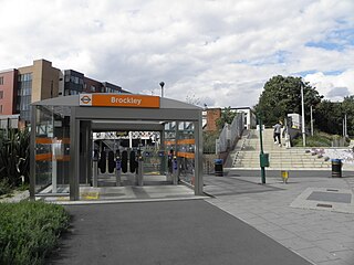
Brockley railway station serves the south-east London district of Brockley and is on the main railway line between London Bridge and Brighton. It is 3 miles 56 chains down the line from London Bridge.

<span class="mw-page-title-main">Queens Road Peckham railway station</span> British railway station

Queens Road Peckham railway station is in the London Borough of Southwark and also serves the area to the east of Peckham, in the London Borough of Lewisham. It is on the South London Line, 2 miles 58 chains (4.4 km) from London Bridge, and trains also go to Croydon via various routes and beyond. It is on the road of that name and is in Travelcard Zone 2.

<span class="mw-page-title-main">East Croydon station</span> National rail station and Tramlink tram stop in London

East Croydon is a railway station and tram stop in Croydon, Greater London, England, and is located in Travelcard Zone 5. At 10 miles 28 chains from London Bridge, it is the 17th busiest station in Britain, was the 10th busiest in 2020–21, and is one of the busiest non-terminal stations in the country. It is one of three railway stations in the London Borough of Croydon with Croydon in their name, the others being West Croydon and South Croydon. A Tramlink tram stop is located immediately outside the main station entrance.

<span class="mw-page-title-main">Honor Oak Park railway station</span> National rail station in London, England

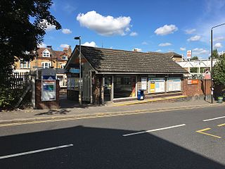
Honor Oak Park railway station serves the suburban area of Honor Oak in the London Borough of Lewisham. It is 4 miles 59 chains down the line from London Bridge, between Brockley and Forest Hill.

<span class="mw-page-title-main">West Croydon station</span> National rail station and Tramlink tram stop in London

West Croydon is a combined railway, bus station and tram stop in Croydon, south London. It is served by National Rail, London Overground, Tramlink and London Buses services and is in Travelcard Zone 5.

<span class="mw-page-title-main">Brighton Main Line</span> Railway line between London and Brighton

The Brighton Main Line is a major railway line in the United Kingdom that links Brighton, on the south coast of England, with central London. In London the line has two branches, out of London Victoria and London Bridge stations respectively, which join up in Croydon and continue towards Brighton as one line. The line is electrified throughout using the third rail system.

<span class="mw-page-title-main">Sydenham railway station (London)</span> National rail station in London, England

Sydenham is a railway station in Sydenham in the London Borough of Lewisham, South London. Originally opened in 1839, the station is located on the former Croydon Canal, which is now a branch of the Brighton Main Line, often known as the Sydenham Corridor. Sydenham falls within Travelcard Zone 3 and is served by London Overground and Southern. The station is 6 miles 32 chains down the line from London Bridge.

<span class="mw-page-title-main">Penge West railway station</span> National rail station in London, England

Penge West railway station is located in Penge, a district of the London Borough of Bromley in south London. The station is operated by London Overground, with Overground and Southern trains serving the station. Thameslink and some Southern services pass through the station. It is 7 miles 15 chains down the line from London Bridge, in Travelcard Zone 4.

<span class="mw-page-title-main">Anerley railway station</span> National rail station in London, England

Anerley railway station is in the London Borough of Bromley in south London. The station is operated by London Overground, with Overground and Southern trains serving the station. It is 7 miles 47 chains down the line from London Bridge, in Travelcard Zone 4.

<span class="mw-page-title-main">Norwood Junction railway station</span> National rail station in London, England

Norwood Junction railway station is a National Rail station in South Norwood in the London Borough of Croydon, south London, and is in Travelcard Zone 4. It is 8 miles 55 chains down the line from London Bridge.

<span class="mw-page-title-main">Norbury railway station</span> Railway station in London, England

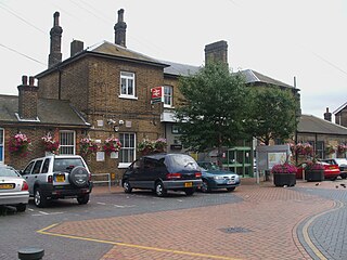
Norbury railway station is a National Rail station in the Norbury area of the London Borough of Croydon in south London. It is on the Brighton Main Line, 7 miles 36 chains (12.0 km) down the line from London Victoria. The station is operated by Southern, which also provides all train services. It is in Travelcard Zone 3 and Ticket barriers are in operation at this station.

<span class="mw-page-title-main">Thornton Heath railway station</span> National Rail station in London, England

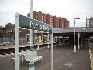
Thornton Heath is a railway station in the London Borough of Croydon in south London, 8 miles 64 chains (14.2 km) down the line from London Victoria. It is on the Brighton Main Line between Norbury and Selhurst. The station is operated by Southern, who also provide all train services.The station is in Travelcard Zone 4.

<span class="mw-page-title-main">Selhurst railway station</span> National Rail station in London, England

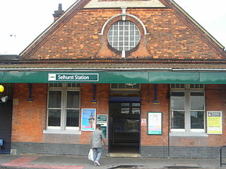
Selhurst railway station is in the London Borough of Croydon in south London, 9 miles 31 chains (15.1 km) along the line from London Victoria. It is operated by Southern, which also provides all the train services. The station is in Travelcard Zone 4.

<span class="mw-page-title-main">Wandsworth Common railway station</span> National Rail station in London, England

Wandsworth Common railway station is in the London Borough of Wandsworth in south London. It is 4 miles 5 chains (6.5 km) down the line from London Victoria.

<span class="mw-page-title-main">Balham station</span> London Underground and railway station

Balham is an interchange station formed of a range of underground entrances for the London Underground ('tube') and a shared entrance with its National Rail station component. The station is in central Balham in the London Borough of Wandsworth, south London, England. The tube can be accessed on each side of the Balham High Road (A24); National Rail on the south side of the road leading east, where the track is on a mixture of light-brick high viaduct and earth embankment, quadruple track and on a brief east–west axis.

References

  1. 1 2 3 4 5 "Estimates of station usage". Rail statistics. Office of Rail Regulation. Please note: Some methodology may vary year on year.
  2. Turner, John Howard (1978). The London Brighton and South Coast Railway 1 Origins and Formation. Batsford. pp. 249–250. ISBN   0-7134-0275-X.
  3. Chronology of London Railways by H.V.Borley
  4. Forgotten Stations of Greater London by J.E.Connor and B.Halford
  5. Howard Turner, John (1978). The London Brighton and South Coast Railway 2 Establishment and Growth. Batsford. pp. 43, 245. ISBN   0-7134-1198-8.
  6. Table 171, 177, 178 National Rail timetable, May 2022
  7. "London Overground Timetable: Highbury & Islington to New Cross, Clapham Junction, Crystal Palace and West Croydon" (PDF). London Overground . Retrieved 4 August 2022.
  8. Forest Hill station/Dartmouth Road
  9. Forest Hill Station/London Road – Bus