Thameslink is a mainline route on the British railway network, running from Bedford, Luton, St Albans City, Peterborough, Welwyn Garden City, London Blackfriars and Cambridge via central London to Sutton, Orpington, Sevenoaks, Rainham, Horsham, Three Bridges, Brighton and East Grinstead. The network opened as a through service in 1988, with severe overcrowding by 1998, carrying more than 28,000 passengers in the morning peak. All the services are currently operated by Govia Thameslink Railway. Parts of the network, from Bedford to Three Bridges, run 24 hours a day, except on early Sunday mornings and during maintenance periods.

London Bridge is a central London railway terminus and connected London Underground station in Southwark, south-east London. It occupies a large area on three levels immediately south-east of London Bridge, from which it takes its name. The main line station is the oldest railway station in London fare zone 1 and one of the oldest in the world having opened in 1836. It is one of two main line termini in London to the south of the River Thames and is the fourth-busiest station in London, handling over 50 million passengers a year.

New Cross Gate is a railway station in New Cross, London, on the Brighton Main Line and the London Overground. It is 2 miles 70 chains down the line from London Bridge and is about 600 m (660 yd) west of New Cross station. It is in Travelcard Zone 2, and is operated by London Overground.

East Croydon is a railway station, tram stop and associated bus station in Croydon, Greater London, England. It is located in Travelcard Zone 5. At 10 miles 28 chains from London Bridge, it is the 20th busiest station in Britain, was the 10th busiest in 2020–21, is the busiest national rail station in London outside of fare zones 1 and 2 and is one of the busiest non-terminal stations in the country. It is one of three railway stations in the London Borough of Croydon with Croydon in their name, the others being West Croydon and South Croydon. A Tramlink tram stop is located immediately outside the main station entrance.

Gatwick Airport railway station is on the Brighton Main Line in West Sussex, England. It serves Gatwick Airport, 26 miles 47 chains (42.8 km) down the line from London Bridge via Redhill. The platforms are about 70 metres (230 ft) to the east of the airport's South Terminal, with the ticket office above the platforms and station entrances and exits directly connected to the terminal. The station is also connected to the airport's North Terminal by the Airport Shuttle people-mover. Gatwick Airport was the busiest station in South East England region from 2017 to 2018. There have been two stations at Gatwick, sited about 0.85 miles (1.37 km) from each other. It is the busiest station in both West Sussex and South East England, and the sixth busiest station in the UK outside of London.

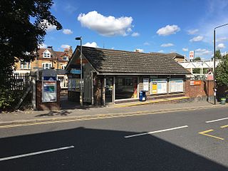
Honor Oak Park railway station serves the suburban area of Honor Oak in the London Borough of Lewisham. It is 4 miles 59 chains down the line from London Bridge, between Brockley and Forest Hill.

Purley railway station is in the London Borough of Croydon on the Brighton Main Line, 13 miles 29 chains (21.50 km) measured from London Bridge, in Travelcard Zone 6. It is a junction, with branches to Caterham and Tattenham Corner.

The Brighton Main Line is a railway line in southern England linking London to Brighton. It starts at two termini in the capital, London Victoria and London Bridge, and the branches from each meet at East Croydon, from where the route continues southwards via Gatwick Airport to the coast. The line serves the suburbs of South London, as well as the towns of Redhill, Horley, Crawley, Haywards Heath and Burgess Hill.

Forest Hill railway station serves Forest Hill in the London Borough of Lewisham, south London. The station adjoins a road which serves as part of the A205 South Circular Road.

Sydenham is a railway station in Sydenham in the London Borough of Lewisham, South London. Originally opened in 1839, the station is located on the former Croydon Canal, which is now a branch of the Brighton Main Line, often known as the Sydenham Corridor. Sydenham falls within Travelcard Zone 3 and is served by London Overground and Southern. The station is 6 miles 32 chains down the line from London Bridge.
Anerley railway station is in the London Borough of Bromley in south London. The station is operated by London Overground, with Overground and Southern trains serving the station. It is 7 miles 47 chains down the line from London Bridge, in Travelcard Zone 4.
Norwood Junction railway station is a National Rail station in South Norwood in the London Borough of Croydon, south London, and is in Travelcard Zone 4. It is 8 miles 55 chains down the line from London Bridge.

Purley Oaks railway station is in the London Borough of Croydon in south London, on the Brighton Main Line 12 miles 34 chains (20.0 km) measured from London Bridge. All trains serving it are operated by Southern and it is in London Travelcard Zone 6. The station has four platforms: a side platform on the up fast line, an island platform with a face on the down fast line and an eastern face used by up trains, and a side platform on the eastern side used by down trains. There is also a pay-and-display car park at the station.

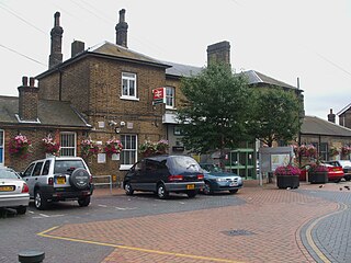
Redhill railway station serves the town of Redhill, Surrey, England. The station is a major interchange point on the Brighton Main Line, 22 miles 40 chains (36.2 km) measured from London Charing Cross. It is managed by Southern, and is also served by Thameslink and Great Western Railway.

Merstham railway station is in Merstham, Surrey, England. It is on the Brighton Main Line, 20 miles 59 chains (33.4 km) measured from London Charing Cross, and train services are currently provided by Southern, who manage the station, and Thameslink.

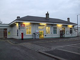
Horsham railway station serves the town of Horsham in West Sussex, England. It is 37 miles 56 chains (60.7 km) down the line from London Bridge, measured via Redhill, on the Arun Valley Line and the Sutton & Mole Valley Lines, and train services are provided by Southern and Thameslink. Services on the Sutton & Mole Valley Line from London Victoria via Dorking terminate here, as do Thameslink services from Peterborough via London Bridge. The other services continue into the Arun Valley: a half-hourly service from London Victoria to Bognor Regis, and a half-hourly service to Portsmouth Harbour. These trains usually divide here with the front (Portsmouth) portion travelling fast and the rear half providing stopping services.

Haywards Heath railway station is on the Brighton Main Line in England, serving the town of Haywards Heath, West Sussex. It is 37 miles 59 chains down the line from London Bridge via Redhill and is situated between Balcombe and Wivelsfield. It is managed by Southern.

Preston Park railway station is on the Brighton Main Line in England, serving Preston Village and the northern suburban areas of the city of Brighton and Hove, East Sussex. It is 49 miles 21 chains (79.3 km) from London Bridge via Redhill, between Hassocks and Brighton.

Hassocks railway station is on the Brighton Main Line in England, serving the village of Hassocks, West Sussex. It is 43 miles 42 chains (70.0 km) down the line from London Bridge via Redhill and is situated between Burgess Hill and Preston Park. It is managed by Southern.

Hove railway station serves Hove, in Brighton and Hove in the county of East Sussex, England. It is 50 miles 56 chains (81.6 km) measured from London Victoria. The station and the majority of trains serving it are operated by Southern.