Sanderstead railway station

Last updated • 2 min readFrom Wikipedia, The Free Encyclopedia

Sanderstead National Rail logo.svg
Sanderstead station building.JPG
Sanderstead Station
Greater London UK location map 2.svg
Red pog.svg
Sanderstead
Location of Sanderstead in Greater London
Location Sanderstead
Local authority London Borough of Croydon
Managed by Southern
Station code(s)SNR
DfT category D
Number of platforms2
Fare zone 6
National Rail annual entry and exit
2019–20Decrease2.svg 1.098 million [1]
2020–21Decrease2.svg 0.212 million [1]
2021–22Increase2.svg 0.508 million [1]
2022–23Increase2.svg 0.624 million [1]
2023–24Increase2.svg 0.780 million [1]
Key dates
10 March 1884Opened
Other information
External links
Coordinates 51°20′54″N0°05′38″W / 51.3484°N 0.094°W / 51.3484; -0.094
Underground sign at Westminster.jpg London transportportal

Sanderstead railway station is on the Oxted Line in the London Borough of Croydon, 1 mile (1.6 km) from Sanderstead village. It is in Travelcard Zone 6, 12 miles 23  chains (12.29 miles, 19.77 km) from London Bridge. The station is managed by Southern.

Contents

On the up (London-bound) platform is a ticket office, staffed for most of the day, and a self-service ticket machine is outside the station on the up side: there is no PERTIS (Permit to travel) machine. Purley Oaks, also in Travelcard Zone 6, is nearby.

History

Sanderstead station looking north from the bridge carrying Sanderstead Road over the line. Sanderstead railway station.JPG
Sanderstead station looking north from the bridge carrying Sanderstead Road over the line.

The station was opened on 10 March 1884 by the London, Brighton and South Coast Railway and the South Eastern Railway with their line between South Croydon and East Grinstead. The population was around 300, rising to 534 by 1901. [2]

In 1913 the station was set alight in an act of arson. The suffragette Elsie Duval was the main suspect. [3] The replacement building was weather-boarded, cheap to construct but requiring regular maintenance. An extensive bookstall was on the up platform, and a signal box on the down platform.

In 1928 the Southern Heights Light Railway was approved, which would have left the Oxted line south east of the station and finished at Orpington. [4] On it would have run a loop service from Charing Cross to Lewisham and then Woodside-Sanderstead-Orpington and back, or vice versa. However, the scheme could not attract investment and was moribund even before electrification of the Woodside and South Croydon Joint Railway as its first stage. This was from Woodside to Selsdon and over a short section of the Oxted Line to Sanderstead, and was completed in 1935. [5] This route terminating at Sanderstead involved the only electric train service at the station until 1984.

These electric trains, on the Woodside and South Croydon Railway via Selsdon to Elmers End, ran from 1935 until the line closed in 1983; at that time, fewer than 150 people were using the service per day, which operated only on weekdays at peak hours to Elmers End. [6]

Electrification of the South Croydon-Selsdon and Sanderstead-East Grinstead sections of the Oxted Line was approved by BR in the early 1980s: South Croydon-Selsdon was electrified in 1984 using some redundant materials from the closed Woodside-Selsdon line, and a London Bridge to Sanderstead electric train service begun. [7]

The station building was destroyed by fire again in June 1986, and a new brick building opened in September 1987. [8] The signal box closed on 2 November 1985, and was demolished in August 1987. [9]

Electrification to East Grinstead was completed in October 1987.

Services

Off-peak, all services at Sanderstead are operated by Southern using Class 377 EMUs.

The typical off-peak service in trains per hour is: [10]

During the middle of the weekday (roughly 11:30-14:30), this service is reduced to one train per hour.

During the peak hours, there are also Thameslink operated services between East Grinstead, London Bridge and Bedford. These services are operated using Class 700 EMUs.

Preceding station National Rail logo.svg National Rail Following station
East Croydon
or
South Croydon
  Southern
  Riddlesdown
  Thameslink
 
Disused railways
Selsdon   British Rail
Southern Region

 Terminus

Connections

London Buses route 403 serves the station. [11]

Related Research Articles

<span class="mw-page-title-main">Thameslink</span> Mainline route in the British railway system

Thameslink is a mainline route on the British railway network, running from Bedford, Luton, St Albans City, Peterborough, Welwyn Garden City, London Blackfriars and Cambridge via central London to Sutton, Orpington, Sevenoaks, Rainham, Horsham, Three Bridges, Brighton and East Grinstead. The network opened as a through service in 1988, with severe overcrowding by 1998, carrying more than 28,000 passengers in the morning peak. All the services are currently operated by Govia Thameslink Railway. Parts of the network, from Bedford to Three Bridges, run 24 hours a day, except on early Sunday mornings and during maintenance periods.

<span class="mw-page-title-main">East Croydon station</span> National rail station and Tramlink tram stop in London

East Croydon is a railway station, tram stop and associated bus station in Croydon, Greater London, England. It is located in Travelcard Zone 5. At 10 miles 28 chains from London Bridge, it is the 20th busiest station in Britain, was the 10th busiest in 2020–21, is the busiest national rail station in London outside of fare zones 1 and 2 and is one of the busiest non-terminal stations in the country. It is one of three railway stations in the London Borough of Croydon with Croydon in their name, the others being West Croydon and South Croydon. A Tramlink tram stop is located immediately outside the main station entrance.

<span class="mw-page-title-main">Orpington railway station</span> Rail station in south-east London

Orpington railway station is on the South Eastern Main Line, serving the town of Orpington in the London Borough of Bromley, south-east London. It is 13 miles 65 chains (22.2 km) down the line from London Charing Cross and is situated between Petts Wood and Chelsfield stations. It is in Travelcard Zone 6.

<span class="mw-page-title-main">Oxted line</span> Railway line in southern England

The Oxted line is a railway line in southern England. It runs from the Brighton Main Line at South Croydon in Greater London to Hurst Green Junction in Surrey, where its two branches diverge. The western branch continues via Lingfield to East Grinstead in West Sussex, whereas the eastern branch runs via Edenbridge Town in Kent to Uckfield in East Sussex. The line is named after the town of Oxted in Surrey and also serves parts of the London Borough of Croydon. The 18-mile-26-chain (29.5 km) South Croydon–East Grinstead section is electrified using the 750 V DC third-rail system and is double track throughout. The unelectrified Hurst Green Junction–Uckfield section is 24 mi 53 ch (39.7 km) in length and, south of Hever, is mostly single track.

<span class="mw-page-title-main">Elmers End station</span> British railway station

Elmers End is a railway station and tram terminus in Elmers End, south London, England. It is in the London Borough of Bromley and on the railway it is 11 miles 7 chains (17.8 km) down the line from London Charing Cross.

<span class="mw-page-title-main">Nunhead railway station</span> National Rail station in London, England

Nunhead railway station is in the Nunhead area of the London Borough of Southwark. It is 5 miles 77 chains (9.6 km) measured from London Victoria. The station is managed by Thameslink. It is in Travelcard Zone 2.

<span class="mw-page-title-main">Woodside and South Croydon Joint Railway</span>

The Woodside and South Croydon Joint Railway (W&SC) was a short, relatively short-lived and unsuccessful railway in the London Borough of Croydon in London, England. Its site is now largely occupied by Tramlink.

<span class="mw-page-title-main">Bromley South railway station</span> National Rail station in London, England

Bromley South railway station is on the Chatham Main Line, serving the town centre and high street of Bromley, south-east London, England. It is 10 miles 71 chains (17.5 km) down the line from London Victoria and is situated between Shortlands and Bickley.

<span class="mw-page-title-main">South Croydon railway station</span> National Rail station in London, England

South Croydon railway station is in the London Borough of Croydon in south London, in Travelcard Zone 5. It is on the Brighton Line at its junction with the Oxted Line, 11 miles 21 chains (18.1 km) measured from London Bridge.

<span class="mw-page-title-main">Purley Oaks railway station</span> South London station on Brighton main line

Purley Oaks railway station is in the London Borough of Croydon in south London, on the Brighton Main Line 12 miles 34 chains (20.0 km) measured from London Bridge. All trains serving it are operated by Southern and it is in London Travelcard Zone 6. The station has four platforms: a side platform on the up fast line, an island platform with a face on the down fast line and an eastern face used by up trains, and a side platform on the eastern side used by down trains. There is also a pay-and-display car park at the station.

<span class="mw-page-title-main">Riddlesdown railway station</span> National Rail station in London, England

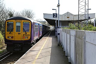
Riddlesdown railway station is on the Oxted line serving Riddlesdown in the London Borough of Croydon, south London. It is in Travelcard Zone 6, 13 miles 38 chains from London Bridge, although off peak trains run to and from London Victoria. It is managed by Southern.

<span class="mw-page-title-main">Hurst Green railway station</span> Railway station in Surrey, England

Hurst Green railway station is on the Oxted line in southern England and serves the Hurst Green neighbourhood of Oxted in Surrey. It is 21 miles 20 chains from London Bridge. The station is managed by Southern.

<span class="mw-page-title-main">Oxted railway station</span> Commuter train station in Surrey, England

Oxted railway station is on the Oxted line in southern England, serving the commuter town of Oxted, Surrey. It is 20 miles 25 chains from London Bridge. The station is managed by Southern who operate the majority of train services with a few peak services operated by Thameslink.

<span class="mw-page-title-main">Upper Warlingham railway station</span> National Rail station in Surrey, England

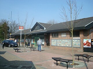
Upper Warlingham railway station is on the Oxted line serving Warlingham and Whyteleafe in Surrey, England. It is in Travelcard Zone 6, 15 miles 33 chains from London Bridge, although off peak trains run to and from London Victoria. The station is managed by Southern.

<span class="mw-page-title-main">Dormans railway station</span> Railway station in Surrey, England

Dormans railway station is on the East Grinstead branch of the Oxted line in southern England. It serves Dormansland and Dormans Park in Surrey. Most trains run between London Victoria and East Grinstead and are operated by Southern. Thameslink trains call at peak times on weekdays.

<span class="mw-page-title-main">East Grinstead railway station</span> Railway station in West Sussex, England

East Grinstead railway station is one of the two southern termini of the Oxted line in the south of England and serves East Grinstead in West Sussex. It is 30 miles 4 chains from London Bridge, although trains mostly run to and from London Victoria. The station is managed by Southern.

<span class="mw-page-title-main">Selsdon railway station</span> Former railway station in England

Selsdon railway station was at the junction of the Croydon, Oxted and East Grinstead Railway and the now-closed Woodside and South Croydon Joint Railway. Opened in 1885 as Selsdon Road, it was 2 miles (3.2 km) from Selsdon village.

<span class="mw-page-title-main">Bingham Road railway station</span> Disused railway station in Addiscombe, Croydon, England

Bingham Road railway station was in Addiscombe, Croydon on the Woodside and South Croydon Joint Railway. It was opened on 1 September 1906 on the north side of Bingham Road, with two wooden platforms without buildings and was closed on 15 March 1915 as a wartime economy measure. A new station on the south side of Bingham Road was opened in 1935 and finally closed in 1983. The modern Addiscombe tram stop at ground level is situated at the location of the first halt closed in 1915 which was situated on an embankment above the present site.

The Southern Heights Light Railway (SHLR) was to have been a speculative London area suburban electric railway between Orpington, Kent and Sanderstead, Surrey. It was authorised in 1928 under the Light Railways Act 1896, but ultimately not constructed. The engineer was to have been Colonel Holman Fred Stephens, heavily involved in the promotion of light railways.

<span class="mw-page-title-main">Coombe Road railway station</span> Former railway station in Croydon, south London

Coombe Road was a railway station on the Woodside and South Croydon Joint Railway in London. When it was closed it was owned and managed by British Rail.

References

  1. 1 2 3 4 5 "Estimates of station usage". Rail statistics. Office of Rail Regulation. Please note: Some methodology may vary year on year.
  2. Mitchell, Vic; Smith, Keith (March 1995). Croydon (Woodside) to East Grinstead (Country Railway Routes). Midhurst, West Sussex: Middleton Press. p. Plate 30. ISBN   1-873793-48-0.
  3. "chertsey museum". chertseymuseum.org. Retrieved 17 March 2019.
  4. "Southern Heights Railway". The Times. No. 45098. London. 11 January 1929. col D, p. 9.
  5. "The Colonel periodical No. 60, Winter 2002 p. 9" (PDF). Retrieved 7 October 2020.
  6. Mitchell, V. and Smith, K., plate 38.
  7. Mitchell, V. and Smith, K., plate 55
  8. Mitchell, V. and Smith, K., plate 39.
  9. Mitchell, V. and Smith, K., plate 35.
  10. Table 181, 182 National Rail timetable, May 2022
  11. "Buses from Purley Oaks and Sanderstead" (PDF). TfL. January 2015. Retrieved 20 June 2020.