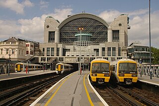
Southern Heights Light Railway

Last updated

Southern Heights Light Railway
Overview
Locale Kent and Surrey, United Kingdom
Technical
Track gauge 4 ft 8+12 in (1,435 mm) (proposed)
Electrification Third rail (proposed)
Length15 miles 64 chains (25.43 km) (proposed)
Southern Heights Light Railway
BSicon CONTg@Gq.svg
BSicon lv-BHF.svg
BSicon eABZq+r.svg
BSicon dCONTfq.svg
0 mi 0 ch
0 km
Orpington
BSicon exHST.svg
1 mi 7 ch
1.75 km
Green Street Green
for Farnborough
BSicon exHST.svg
3 mi 5 ch
4.93 km
Downe and Keston
BSicon exHST.svg
5 mi 14 ch
8.33 km
Cudham and Biggin Hill
BSicon exHST.svg
6 mi 11 ch
9.88 km
Westerham Hill
BSicon exSTR+GRZq.svg
BSicon exHST.svg
8 mi 9 ch
13.06 km
Tatsfield
BSicon exHST.svg
11 mi 44 ch
18.59 km
Chelsham
BSicon exHST.svg
12 mi 5 ch
19.41 km
Hamsey Green
BSicon exHST.svg
14 mi 12 ch
22.77 km
Mitchley Wood
BSicon CONTg@Gq.svg
BSicon lv-BHF.svg
BSicon eABZqr.svg
BSicon dCONTfq.svg
15 mi 64 ch
25.43 km
Sanderstead

Station distances are from Orpington,
which is 13  mi 65  ch (22.23 km) from
London Charing Cross.

Contents

The Southern Heights Light Railway (SHLR) was to have been a speculative London area suburban electric railway between Orpington, Kent and Sanderstead, Surrey. It was authorised in 1928 under the Light Railways Act 1896, but ultimately not constructed. The engineer was to have been Colonel Holman Fred Stephens, heavily involved in the promotion of light railways.

History

Plotlands

The context of the scheme lay in the suburban development of a remote rural area near the crest of the North Downs on the Kent-Surrey border, comprising the tiny hamlet of Biggin Hill in the former together with the small but ancient village of Tatsfield in the latter.

This locality was an early example of a plotland development, of which many examples sprang up in countryside around major cities in the first half of the 20th century. The process involved speculative developers buying up failed country farms or estates, and dividing the land into portions or plots of about an acre which were then sold off to individuals to do with as they pleased. This was before the existence of laws governing planning permission. The results were usually settlements of poor quality residences lacking utilities and social services, accessed by unmade tracks. [1]

The Aperfield Court Estate at Biggin Hill was bought by a London speculator called Frederick Dougal in 1889,. [2] He divided up the land into plots which he sold off for £10 each with a £1 deposit (£1300 in 2020 values, £130 down). However, interest was limited by the remoteness of the locality. Such plotlands only became popular with the arrival of private road vehicles. [3]

Orpington, Cudham and Tatsfield Light Railway

The answer here was the promotion of a speculative branch railway from Orpington on the South Eastern Railway, with the hope that this would encourage interest in suburban development. The Orpington, Cudham and Tatsfield Light Railway Company (OCTR) was therefore incorporated in 1898, with Colonel Holman Fred Stephens as the engineer.

The company obtained a Light Railway Order in 1902, authorising construction of a 7.5 mile (12 km) line which was to be completed in four years. [4] Authorised capital was £70 000, [5] and the South Eastern Railway was to work the line once completed. Unfortunately, investment was not forthcoming and construction did not begin. [6]

Route of the OCTLR

The 1902 proposal involved a line running due south of Orpington to a station at Green Street Green, just south of the road called Farnborough Hill and west of High Street. It then turned south-west to run up the valley occupied by Cuckoo Wood to Cudham station at Hang Grove Hill. From there hugged the east side of Berry's Green before turning due west to Biggin Hill station on the present A233 road, about the south end of Aperfield Road. It then ran south-east and south to cross Tansfield Lane, then paralleled that road westwards to its terminus of Tatsfield station where Tatsfield Primary School used to be, by the crossroads at the top of Church Hill. [7]

SHLR proposal

The OCTLR was defunct after 1906. However, the scheme was revived in a more ambitious form when the Southern Heights Light Railway was proposed in the mid 1920s. Colonel H. F. Stephens was the engineer again, forming a personal link between the two schemes, and he was also to be a major promoter in his own right despite calling himself the "Agent to the Promoters". [8] [9]

The SHLR scheme first drew wider public attention in March 1925, when an inquiry into the proposed line was held at Orpington, Kent. It was to have been a single track railway constructed across the North Downs from Orpington to Sanderstead. [8] In a departure from Stephens' usual practice, there were to have been no level crossings at all on the line, which would have required 23 bridges to have been built. Construction of the line would have required the excavation of 631,000 cubic yards (482,000 m3) of material. [10]

The line was to have been electrified by the third rail system, and was to have been operated by the Southern Railway as part of its suburban electric railway network. [11] Passenger trains would have been operated by electric multiple units, with steam locomotives handling goods trains.

The Southern Railway involvement was vital. That company's chairman, Sir Herbert Ashcombe Walker, addressed its board on the scheme's behalf in February 1926, just before the application for a Light Railway Order. The total cost he estimated to be £800 000, so it was proposed that the capital applied for was to be £900 000. £600 000 of this was to be in ordinary shares and £300 000 to be in guaranteed interest debentures. Sir Herbert obtained the board's approval for the SR to guarantee the interest on the latter, and to work the line in return for 75% of the gross receipts. Also, approval was given for the SR to invest in the scheme, and to have the option to purchase at cost price within five years of completion. In return, two of the SHLR directors were to be nominated by the SR board. [12]

A subsequent meeting of the board, in the same month, fixed the SR investment at £150 000, which was intended to pay for the cost of electrification.

SHLR approval

The Light Railway Order (LRO) was granted provisionally on 29 December 1928. Instead of the expected share capital of £600 000, only £500 000 was authorised. Simultaneously, the SHLR and SR signed a working agreement. Notably, this specified that the line was to be single, but was to be engineered to allow for future double track. Also, timetabling and fares were to be the responsibility of the SR. The latter began to include the scheme in its publicity, notably on its system maps. [13]

A revised estimate of the cost of purchasing land and erecting necessary buildings (that is, excluding that of building the actual railway line) was given as £575 000. Only three of the proposed stops were to be built as full stations, and the company requested that level crossing be allowed "where necessary" (this was in contradiction to the scheme's original publicity).

The provisional nature of the LRO involved certain conditions: The authorised capital was to be raised, and the land purchased, within two years, which meant that the authorisation would lapse at the end of 1930. In that year, Colonel Stephens made a fund-raising trip to the United States, with no success. [14]

Failure

The LRO lapsed in December 1930, as the capital could not be raised.

In January 1931, as a result, a new LRO was applied for and authorisation was sought to deviate from the authorised route in an effort to reduce construction costs by £17,245. The line was to have taken a different route in the parishes of Cudham, Tatsfield and Titsey, on the Kent/Surrey border. [15]

The scheme faded away in the 1930s, [16] after Colonel Stephens died in October 1931 and the scheme lost its main promoter. The death blow had already been given in July of that year, when the SR board decided not to support the application for a new LRO and the scheme was deleted from SR publicity. [17]

Legacy

The only construction that started was south of Orpington station on the east side of the line; some excess spoil was delivered to the site during the 1930s ready for construction. The SR had to electrify a connection to the proposed western junction at Sanderstead, and chose the previously failed Woodside and South Croydon Joint Railway. This would have allowed a loop service from the former South Eastern Railway London termini, running Lewisham - Woodside - Sanderstead - Orpington - Lewisham and vice versa. [16] [18] Despite the SR's abandonment of support in 1931, electrification works already in hand were allowed to go ahead, and electric trains from London termini to Sanderstead via Woodside began in 1935. They were to continue until 1983, latterly as a very poorly patronised peak-hours shuttle service.

Stops

The proposed line would have served eight stops between Orpington and Sanderstead, three of which were to be full stations with goods services. The other five were to be "halts", for passengers only. [18]

Route

The scheme's proposed route was on the dip slope of the North Downs, so the roughly S-shaped route entailed continuous ascending gradients from Orpington to the summit on the crest of the Downs near Tatsfield, then similarly continuous descending gradients to Sanderstead.

The circuitous nature of the route meant that the proposed railway would not have attracted through traffic, especially since there was no direct passenger connection allowed for to the Brighton main line near Sanderstead. So, the railway was envisaged entirely as a suburban commuter route to the London termini. Given this, it is noticeable that the proposed stops were quite widely spaced compared to the Southern Railway's London suburban lines in general. [19]

The topography added a further complication, this being the need to avoid crossing the several steep-sided narrow valleys which dissect the dip slope, and which would have required viaducts. This put serious constraints on the choices for the route.

At Orpington station there was to have been a diving junction, so that the SHLR down trains would not have to cross the main line here. [20] South of Orpington station on the east side of the line some excess spoil was delivered to the site during the 1930s ready for construction and in 2023 was still in situ. Green Street Green Halt would have been around the junction between Shire Lane and Farnborough Hill, west of the station site proposed for the earlier OCTR. This was because the SHLR proposed a different, longer route to Tatsfield via the valley up which Shire Lane runs. This valley curves south to the east of Leaves Green and Biggin Hill Airport, and Downe and Keston Halt would have been around New Hill Road. Cudham and Biggin Hill would have been around Jail Lane.

The first true station with goods services, Westerham Hill, would have been in South Street (the actual hill is away to the south). Here, the line would have turned west to the second true station at Tatsfield. The fact that two out of three of the true stations proposed for the line were so close together is an indication that the focus of the scheme was very much on the Biggin Hill - Tatsfield suburban development. Beyond Tatsfield would have been the route's summit, at Botley Hill (the highest point on the North Downs).

The route would then have followed the Croydon Road (the present B269) to Chelsham for Warlingham Halt around Chelsham Road -this was a long stretch without any stop proposed. The third true station would have been at Hamsey Green, where the line would have crossed the Limpsfield Road (B269). Mitchley Wood Halt would have been around the west end of Mitchley Hill, near the junction with the A2022, and would have been substantially nearer the old village of Sanderstead than the SR station of the same name. Mitchley Wood survives mostly intact as a semi-natural ancient woodland. From there, the route would have hugged the slope of Purley Downs, cutting through the golf course to descend to the junction with the SR's Oxted line. [21]

The actual junction was to have been at the bridge carrying Purley Downs Road over the Oxted line, and unlike at Orpington this junction would have been on the level. [22]

Related Research Articles

<span class="mw-page-title-main">Thameslink</span> Mainline route in the British railway system

Thameslink is a 24-hour mainline route on the British railway network, running from Bedford, Luton, St Albans City, Peterborough, Welwyn Garden City, London Blackfriars and Cambridge via central London to Sutton, Orpington, Sevenoaks, Rainham, Horsham, Three Bridges, Brighton and East Grinstead. The network opened as a through service in 1988, with severe overcrowding by 1998, carrying more than 28,000 passengers in the morning peak. All the services are currently operated by Govia Thameslink Railway.

<span class="mw-page-title-main">Northern line</span> London Underground line

The Northern line is a London Underground line that runs from North London to South London. It is printed in black on the Tube map. The Northern line is unique on the Underground network in having two different routes through central London, two southern branches and two northern branches. Despite its name, it does not serve the northernmost stations on the Underground, though it does serve the southernmost station at Morden, the terminus of one of the two southern branches.

<span class="mw-page-title-main">Biggin Hill</span> Human settlement in England

Biggin Hill is a town in South East London, England, within the London Borough of Bromley. It is situated beyond London's contiguous built-up area in the Metropolitan green belt, 15.2 miles (24.5 km) south-southeast of Charing Cross. It is located adjacent to the Greater London boundary with Kent and Surrey. Prior to the creation of Greater London in 1965, it was in the historic and administrative county of Kent. At the 2011 Census, Biggin Hill had a population of 9,951.

<span class="mw-page-title-main">Herne Hill railway station</span> Railway station in Lambeth, South London, England

Herne Hill railway station is in the London Borough of Lambeth, South London, England, on the boundary between London fare zones 2 and 3. Train services are provided by Thameslink to London Blackfriars, Farringdon, St Pancras International and St Albans on the Thameslink route and by Southeastern to London Victoria and Orpington on the Chatham Main Line. It is 3 miles 76 chains (6.4 km) down the line from Victoria.

<span class="mw-page-title-main">Downe</span> Human settlement in England

Downe, formerly Down, is a village in Greater London, England, located within the London Borough of Bromley but beyond London's contiguous urban area. Downe is 3.4 miles (5.5 km) south west of Orpington and 14.2 miles (22.9 km) south east of Charing Cross. Downe lies on a hill, and much of the centre of the village is unchanged; the former village school now acts as the village hall. The word Downe originates from the Anglo Saxon word dūn, latterly down, hence the South and North Downs. In April 1965, Downe and the remaining part of Orpington Urban District Council, was abolished, and transferred from the historic county of Kent and placed within the newly created London Borough of Bromley.

<span class="mw-page-title-main">Warlingham</span> Village in Surrey, England

Warlingham is a village and civil parish in the Tandridge district of Surrey, England, 14 miles (23 km) south of London and 22 miles (35 km) east of Guildford. Warlingham is the centre of a civil parish that includes Hamsey Green to the north. Caterham is 2 miles (3.2 km) to the southwest.

<span class="mw-page-title-main">Orpington railway station</span> Rail station in south-east London

Orpington railway station is on the South Eastern Main Line, serving the town of Orpington in the London Borough of Bromley, south-east London. It is 13 miles 65 chains (22.2 km) down the line from London Charing Cross and is situated between Petts Wood and Chelsfield stations. It is in Travelcard Zone 6.

Colonel Holman Fred Stephens was a British light railway civil engineer and manager. He was engaged in engineering and building, and later managing, 16 light railways in England and Wales.

<span class="mw-page-title-main">Oxted line</span> National Rail line in southern England

The Oxted line is a railway in southern England and part of the Southern franchise. The railway splits into two branches towards the south and has direct trains throughout to London termini.

<span class="mw-page-title-main">Sanderstead railway station</span> National Rail station in London, England

Sanderstead railway station is on the Oxted Line in the London Borough of Croydon, 1 mile (1.6 km) from Sanderstead village. It is in Travelcard Zone 6, 12 miles 23 chains from London Bridge. The station is managed by Southern.

<span class="mw-page-title-main">Woodside and South Croydon Joint Railway</span>

The Woodside and South Croydon Joint Railway (W&SC) was a short, relatively short-lived and unsuccessful railway in the London Borough of Croydon in London, England. Its site is now largely occupied by Tramlink.

<span class="mw-page-title-main">Sutton railway station (London)</span> National Rail station in London, England

Sutton railway station (sometimes referred to as Sutton (Surrey) on tickets and timetables) is in the London Borough of Sutton in South London and is the main station serving the town of Sutton. It is served by Southern and Thameslink trains, and lies in Travelcard Zone 5, 14 miles 75 chains (14.94 miles, 24.04 km) down the line from London Bridge, measured via Forest Hill.

<span class="mw-page-title-main">Cricklewood railway station</span> National Rail station in London, England

Cricklewood railway station is on the Midland Main Line in England, serving the town of Cricklewood in the London Borough of Barnet, north London. It is 5 miles 9 chains (8.2 km) down the line from St Pancras and is situated between West Hampstead Thameslink to the south and Brent Cross West to the north. Its three-letter station code is CRI.

<span class="mw-page-title-main">South Eastern Main Line</span> Major long-distance railway line in south-east England

The South Eastern Main Line is a major long-distance railway route in South East England, UK, one of the three main routes crossing the county of Kent, going via Sevenoaks, Tonbridge, Ashford and Folkestone to Dover. The other routes are the Chatham Main Line which runs along the north Kent coast to Ramsgate or Dover via Chatham and High Speed 1 which runs through the centre of Kent to the coast at Folkestone where it joins the Channel Tunnel.

<span class="mw-page-title-main">Tatsfield</span> Human settlement in England

Tatsfield is a village and civil parish in the Tandridge District of Surrey, England. It is located 3.3 miles north west of Westerham and 3.9 miles north east of Oxted, and is adjacent to the Surrey border with both Greater London and Kent.

The Cairn Valley Light Railway was a rural railway line built to connect Moniaive and other communities in the Cairn Valley with the main railway network at Dumfries. It opened in 1905 but usage was disappointing, and declined further when bus companies started competing. It was closed to passengers in 1943, and completely closed in 1949.

Transportation needs within the county of Kent in South East England has been served by both historical and current transport systems.

The Amesbury and Military Camp Light Railway was a branch line in Wiltshire, England, constructed under a light railway order dated 24 September 1898. It was opened for military traffic from Amesbury to the east-facing Newton Tony Junction on 1 October 1901. A west-facing junction, Amesbury Junction, where the branch burrowed under the main line, opened on 2 June 1902. The line closed in 1963.

<span class="mw-page-title-main">Berry's Green</span> Human settlement in England

Berry's Green a small hamlet in the London Borough of Bromley in Greater London, UK, situated outside of London's contiguous built-up area. It is a fairly wooded rural area with a scattering of farmland. Housing consists mainly of detached properties, mostly bungalows, with a row of local authority cottages and a static mobile home site. It is part of the largest ward in Greater London, Darwin (ward), which covers a very rural area, including Downe, Cudham, Leaves Green, Single Street, Luxted, and Westerham Hill.

<span class="mw-page-title-main">Coombe Road railway station</span> Former railway station in Croydon, south London

Coombe Road was a railway station on the Woodside and South Croydon Joint Railway in London. When it was closed it was owned and managed by British Rail.

References

  1. "The Plotlanders" . Retrieved 12 October 2020.
  2. "The Story of Biggin Hill, Early History" . Retrieved 12 October 2020.
  3. "The Story of Biggin Hill, Sale of the Aperfield Estate" . Retrieved 12 October 2020.
  4. Grant, Donald J: Directory of the Railway Companies of Great Britain 2017 p. 431
  5. "The Story of Biggin Hill, Railways" . Retrieved 12 October 2020.
  6. "Tatsfield Light Railway 1898" . Retrieved 12 October 2020.
  7. "Tatsfield Light Railway map" . Retrieved 12 October 2020.
  8. 1 2 Glover 2001, p. 109.
  9. "The Colonel No. 69 Winter 2002 p. 9" (PDF). Retrieved 12 October 2020.
  10. "Southern Heights Railway". The Times. No. 45098. London. 11 January 1929. col D, p. 9.
  11. Klapper, Charles. "Some English Railway Might-Have-Beens" (PDF). RCHS Journal. Railway and Canal Historical Society (May 2004): 433. Retrieved 15 July 2015.
  12. "The Colonel No. 69 Winter 2002 p. 11" (PDF). Retrieved 12 October 2020.
  13. "The Colonel No. 69 Winter 2002 p. 11" (PDF). Retrieved 12 October 2020.
  14. "Farnborough Village: Southern Heights Light Railway" . Retrieved 12 October 2020.
  15. "Southern Heights Railway". The Times. No. 45717. London. 10 January 1931. col C, p. 12.
  16. 1 2 3 4 5 6 7 8 9 10 11 "The Southern Heights Light Railway". Chelsham Bus Garage. Retrieved 15 July 2015.
  17. "The Colonel No. 69 Winter 2002 p. 12" (PDF). Retrieved 12 October 2020.
  18. 1 2 3 4 5 6 7 8 9 10 11 "Southern Heights Light Railway". Railwaycodes. Retrieved 15 July 2015.
  19. "Farnborough Village: Southern Heights Light Railway" . Retrieved 13 October 2020.
  20. "The Colonel No. 69 Winter 2002 p. 11" (PDF). Retrieved 12 October 2020.
  21. "Southern Heights Light Railway map" . Retrieved 13 October 2020.
  22. "The Colonel No. 69 Winter 2002 p. 11" (PDF). Retrieved 13 October 2020.
Sources

Further reading