Titsey

Last updated

Titsey
Titsey Place Oxted Surrey.jpg
Titsey Place is the surviving manor of Titsey but a stately home that is open for visitors and is charitably run
Surrey UK location map.svg
Red pog.svg
Titsey
Location within Surrey
Area10.99 km2 (4.24 sq mi)
Population272 (Civil Parish 2011) [1]
  Density 25/km2 (65/sq mi)
OS grid reference TQ4157
  London 16 mi (26 km)  NNE
Civil parish
  • Titsey
District
Shire county
Region
Country England
Sovereign state United Kingdom
Post townWESTERHAM
Postcode district TN16
Post townOXTED
Postcode district RH8
Dialling code 01959
Police Surrey
Fire Surrey
Ambulance South East Coast
UK Parliament
List of places
UK
England
Surrey
51°16′48″N0°00′36″E / 51.280°N 0.010°E / 51.280; 0.010
Titsey lies on the Pilgrims' Way, as shown in this Ordnance Survey map. The north-south road at the extreme right, and the "Clarkslane Shaw" field boundary top centre, lie on the track of a Roman road. Pilgrims Way Titsey.jpg
Titsey lies on the Pilgrims' Way, as shown in this Ordnance Survey map. The north–south road at the extreme right, and the "Clarkslane Shaw" field boundary top centre, lie on the track of a Roman road.

Titsey is a rural village and a civil parish on the North Downs almost wholly within the M25 London Orbital Motorway in the Tandridge District of Surrey, England.

Contents

In local government it forms the south-western part of the ward Tatsfield and Titsey and in national statistics approximates to output area E00157289. It has no railway stations however one is centred 1.5 miles (2.4 km) south-west, Oxted which also has the administrative centre of the district. Approximately half of it land is owned by a charity running the Titsey Place estate, with the remainder being a mixture of common and privately owned woodland and smallholdings.

History

The village lay within the Tandridge hundred, of greatest use in the Anglo-Saxon Kingdom of England and it continues to form a parish in the church of England until its church became appropriated by that of Tatsfield. [3]

The eastern parish boundary follows the London to Lewes Way Roman road which descends the escarpment of the North Downs here, crossing two important ancient east–west routes, the North Downs ridgeway and the Pilgrims Way on the lower slopes. [4]

Titsey appears in Domesday Book of 1086 as a village: Ticesei held by Haimo the Sheriff (of Kent) when its assets were: 2 hides; 1 church, 9 ploughs, pasture worth every seventh hog of the villains. It rendered £11 per year to its feudal system overlords. [5]

The parish church of St James the Greater dates from 1861 and is on the site of an earlier church built in 1776. That in turn replaced a much older church, dating from the 14th century. [6] Some of the memorials to the Gresham family date from the 16th and 17th centuries. [7] There is a 19th century side chapel with memorials to the Leveson-Gower family. [6]

Until the early 20th century, the local economy was entirely agricultural. [6]

In 1929, the BBC established its radio signals receiving station in the parish of Titsey, though the facility was named after the nearby village of Tatsfield. The station's masts and shortwave aerials were a prominent local landmark. [8] [9] The station closed in 1974 when its work was merged with that of BBC Monitoring's receiving station at Crowsley Park in South Oxfordshire. [10] Some derelict remains of the BBC station can still be seen. [11]

Demography and housing

2011 Census Homes
Output areaDetachedSemi-detachedTerracedFlats and apartmentsCaravans/temporary/mobile homes/houseboatsShared between households [1]
E0015728967372200

The average level of accommodation in the region composed of detached houses was 28%, the average that was apartments was 22.6%.

2011 Census Households
Output areaPopulationHouseholds% Owned outright% Owned with a loanhectares [1]
E0015728927210836.123.11,099

The proportion of households who owned their home outright compares to the regional average of 35.1%. The proportion who owned their home with a loan compares to the regional average of 32.5%. The remaining % is made up of rented dwellings (plus a negligible % of households living rent-free).

In 2011 the ward of the United Kingdom, Tatsfield and Titsey, almost twice its size, had 1,816 inhabitants

Local government

The (civil) parish council clerk is David Innes. [12] [13]

Geography

Titsey covers a long tract which reaches up the southern escarpment of the North Downs, specifically to the highest point of the range, Botley Hill, which is in the parish. The north has altitude of around 230 metres (750 ft) where the North Downs Way passes through the parish. Springs in Titsey, rising at the foot of the chalk scarp of the North Downs, are the source of the River Eden. [14] [15]

It is a dispersed settlement bordering Farleigh to the north and the London Borough of Bromley to the north-east. Biggin Hill is to the north-east, across the village centre of Tatsfield. The boundary with Kent is centred 1.5 miles (2.4 km) east. Titsey has two post towns depending on exact location.

Map showing the position of Titsey in Tandridge Tandridge Civil Parishes.png
Map showing the position of Titsey in Tandridge

Related Research Articles

<span class="mw-page-title-main">Tandridge District</span> Non-metropolitan district in England

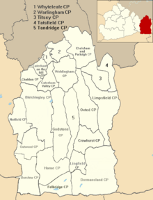
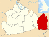
Tandridge is a local government district in east Surrey, England. Its council is based in Oxted, although the largest settlement is Caterham; other notable settlements include Warlingham, Godstone and Lingfield. In mid-2019, the district had an estimated population of 88,129.

<span class="mw-page-title-main">Lingfield, Surrey</span> Village, civil parish and post town in Tandridge District, Surrey, South East England

Lingfield is a village and civil parish in the Tandridge district of Surrey, England, approximately 23 miles (37 km) south of London. Several buildings date from the Tudor period and the timber-frame medieval church is Grade I listed. The stone cage or old gaol, constructed in 1773, was last used in 1882 to hold a poacher.

<span class="mw-page-title-main">Warlingham</span> Village in Surrey, England

Warlingham is a village and civil parish in the Tandridge district of Surrey, England, 14 miles (23 km) south of London and 22 miles (35 km) east of Guildford. Warlingham is the centre of a civil parish that includes Hamsey Green to the north. Caterham is 2 miles (3.2 km) to the southwest.

<span class="mw-page-title-main">Oxted</span> Town and civil parish in Surrey, England

Oxted is a town and civil parish in the Tandridge district of Surrey, England, at the foot of the North Downs. It is 9 miles (14 km) south south-east of Croydon in Greater London, 9 miles (14 km) west of Sevenoaks in Kent, and 9 miles (14 km) north of East Grinstead in West Sussex.

<span class="mw-page-title-main">Caterham</span> Town in Surrey, England

Caterham is a town in the Tandridge District of Surrey, England. The town is administratively divided into two: Caterham on the Hill, and Caterham Valley, which includes the main town centre in the middle of a dry valley but rises to equal heights to the south. The town lies close to the A22, 21 miles from Guildford and 6 miles south of Croydon, in an upper valley cleft into the dip slope of the North Downs. Caterham on the Hill is above the valley to the west.

<span class="mw-page-title-main">Chaldon</span> Human settlement in England

Chaldon is a village and civil parish in the Tandridge District of Surrey, England. The village is situated high on the North Downs, immediately west of Caterham and 15.8 miles (25.4 km) south of Charing Cross, the traditional centre of London.

<span class="mw-page-title-main">Godstone</span> Human settlement in England

Godstone is a village and civil parish in the Tandridge District of Surrey, England. It is 6 miles (9.7 km) east of Reigate, 3 miles (4.8 km) west of Oxted, 22 miles (35 km) east of Guildford and 18 miles (29 km) south of London. Close to the North Downs and Blindley Heath. The Greensand Way and the North Downs Way both pass through Godstone.

<span class="mw-page-title-main">Limpsfield</span> Human settlement in England

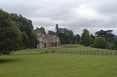
Limpsfield is a village and civil parish in Surrey, England, at the foot of the North Downs close to Oxted railway station and the A25. The composer Frederick Delius and orchestral conductor Sir Thomas Beecham are buried in the village churchyard and there are 89 listed buildings.

<span class="mw-page-title-main">Woldingham</span> Human settlement in England

Woldingham is a village and civil parish high on the North Downs between Oxted and Warlingham in Surrey, England, within the M25, 17.5 miles (28.2 km) southeast of London. The village has 2,141 inhabitants, many of whom commute to London, making Woldingham part of the London commuter belt. The village is served by the Oxted line and central London can be reached in 33 minutes by train.

<span class="mw-page-title-main">Tatsfield</span> Human settlement in England

Tatsfield is a village and civil parish in the Tandridge District of Surrey, England. It is located 3.3 miles north west of Westerham and 3.9 miles north east of Oxted, and is adjacent to the Surrey border with both Greater London and Kent.

<span class="mw-page-title-main">Headley, Surrey</span> Human settlement in England

Headley is a village and civil parish in the North Downs in Surrey, England. The nearest settlements are, to the west, Mickleham and Leatherhead; to the north, Ashtead and Langley Vale; to the east, Walton-on-the-Hill; and to the south, Box Hill. It is just outside the M25 motorway encircling London.

<span class="mw-page-title-main">Farleigh, Surrey</span> Human settlement in England

Farleigh is a village and former civil parish, now in the parish of Chelsham and Farleigh in the Tandridge district of Surrey, England. It is located in the North Downs AONB and the Metropolitan Green Belt, 4.5 miles (7.2 km) south east of Croydon, 13.4 miles (21.6 km) south of London and 25 miles (40 km) WNE of Surrey's county town, Guildford. In 1961 the parish had a population of 1285.

<span class="mw-page-title-main">Wotton, Surrey</span> Human settlement in England

Wotton is a well-wooded parish with one main settlement, a small village mostly south of the A25 between Guildford in the west and Dorking in the east. The nearest village with a small number of shops is Westcott. Wotton lies in a narrow valley, collecting the headwaters of the Tilling Bourne which then has its first combined flow in the Vale of Holmesdale. The parish is long north to south, reaching to the North Downs escarpment in the north to the escarpment of the Greensand Ridge at Leith Hill in the south.

<span class="mw-page-title-main">Felbridge</span> Human settlement in England

Felbridge is a village and civil parish in the Tandridge district of Surrey with a playing field within its focal area, narrowly in West Sussex. Felbridge village forms a contiguous settlement with East Grinstead and had 829 homes and households at the time of the 2011 census. Domewood is part of Felbridge civil parish, which was created in 1953.

<span class="mw-page-title-main">Nutfield, Surrey</span> Village in England

Nutfield is a village and civil parish in the Tandridge District of Surrey, England. It lies in the Weald immediately south of the Greensand Ridge and has a railway station at South Nutfield which is one stop from Redhill, on the Redhill to Tonbridge Line. It includes a watersports park and picnic destination, Mercers Country Park.

Tandridge Hundred was a hundred in Surrey, England. It comprised areas in the Tandridge District, the easternmost part of the county, bordering Kent, West Sussex and the 1965-created county of Greater London.

<span class="mw-page-title-main">Chelsham</span> Human settlement in England

Chelsham is a village and former civil parish, now in the parish of Chelsham and Farleigh and the Tandridge district of Surrey, England. It is located in the Metropolitan Green Belt, 15.3 miles (24.6 km) from London, 3 miles (4.8 km) from Oxted and 23.8 miles (38.3 km) from Guildford. In 1961 the parish had a population of 1285.

<span class="mw-page-title-main">London to Lewes Way</span> Roman road in England

The London to Lewes Way is a 71 kilometres (44 mi) long Roman road between Watling Street at Peckham and Lewes in Sussex. The road passes through Beckenham and West Wickham, then crosses the North Downs above Titsey, on the county boundary between Surrey and Kent, and is overlain by Edenbridge High Street. The road continues on this alignment onto the high ground of Ashdown Forest, where the more grassy vegetation on the silted up outer ditches contrasts very clearly with surrounding heather in aerial photographs, then descends through Piltdown to Lewes, linking with the Sussex Greensand Way at Barcombe Mills and with a network of roads at Lewes.

<span class="mw-page-title-main">Tatsfield Receiving Station</span> Radio receiving station in Surrey

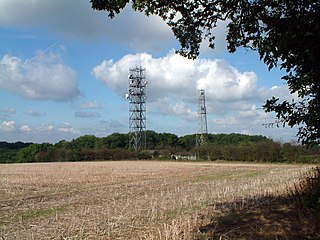
The Tatsfield Receiving Station – known formally as the BBC Engineering Measurement and Receiving Station – was a radio broadcasting signals-receiving and frequency-measuring facility operated by the British Broadcasting Corporation (BBC) on the North Downs just south of London in the United Kingdom.

References

  1. 1 2 3 Key Statistics; Quick Statistics: Population Density 2011 United Kingdom census Office for National Statistics Retrieved 21 November 2013
  2. Margary, Ivan (1948). Roman Ways in the Weald (3 ed.). London: J. M. Dent. p. 133. OCLC   4611036.
  3. Tatsfield St Mary Church of England. Retrieved 31 December 2013
  4. Margary (1948: 130)
  5. Surrey Domesday Book Archived 15 July 2007 at the Wayback Machine
  6. 1 2 3 "Parishes: Titsey Pages 330-334 A History of the County of Surrey: Volume 4". British History Online. Victoria County History, 1912. Retrieved 16 June 2023.
  7. "Church of St James the Greater". British Listed Buildings. Retrieved 16 June 2023.
  8. "The BBC Engineering Measurement and Receiving Station at Tatsfield" Recollections of BBC engineering from 1922 to 1997
  9. "The BBC Engineering Measurement and Receiving Station at Tatsfield" BBC Engineering Information Department pamphlet, 1961
  10. Information relating to the Tatsfield Monitoring Station BBC response to Freedom of Information request, January 2010
  11. Derelict Places Tatsfield Monitoring Station
  12. Tandridge Census Statistics
  13. Tandridge Borough Council
  14. Long, George; Porter, George (1850). The geography of Great Britain. London: Woodall. p. 50. OCLC   33113443.
  15. Wooldridge, Sidney; Hutchings, Geoffrey (1957). "The scarp-zone foot". London's Countryside: Geographical Field Work for Students and Teachers of Geography . London: Methuen. p.  153. OCLC   519129.

Commons-logo.svg Media related to Titsey at Wikimedia Commons