Chelsham and Farleigh

Last updated

Chelsham and Farleigh
Washpond Cottages, Washpond Lane, CR6 - geograph.org.uk - 53359.jpg
Fields, home and woods in Washpond Lane, Chelsham
Surrey UK location map.svg
Red pog.svg
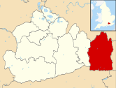
Chelsham and Farleigh
Chelsham and Farleigh shown within Surrey
Area14.91 sq mi (38.6 km2)
Population865 (Civil Parish) [1]
  Density 58/sq mi (22/km2)
OS grid reference TQ372602
  London 14 mi (23 km)  NNW
Civil parish
  • Chelsham and Farleigh
District
Shire county
Region
Country England
Sovereign state United Kingdom
Post town WARLINGHAM
Postcode district CR6
Dialling code 01883
Police Surrey
Fire Surrey
Ambulance South East Coast
EU Parliament South East England
UK Parliament
Website Chelsham and Farleigh Parish Council
List of places
UK
England
Surrey
51°19′01″N0°01′55″W / 51.317°N 0.032°W / 51.317; -0.032 Coordinates: 51°19′01″N0°01′55″W / 51.317°N 0.032°W / 51.317; -0.032

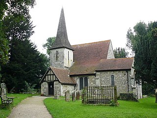
Chelsham and Farleigh is a civil parish in the Tandridge District of Surrey, England. The parish is high on the North Downs and centred 14 miles (23 km) south-southeast of central London and it adjoins the Greater London boundary; it is a predominantly rural/wooded parish aside from minority of land used for homes and gardens. Other than the villages of Chelsham and Farleigh, the parish also includes the hamlet of Fickleshole. The parish was created on 1 April 1969 as an amalgamation of its two named small villages.

Tandridge District Non-metropolitan district in England

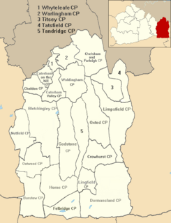
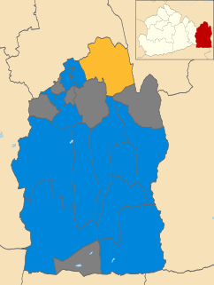
Tandridge is a local government district in east Surrey, England containing part of the North Downs Area of Outstanding Natural Beauty, part of the Weald and the towns of Warlingham, Caterham, Oxted, Godstone and Lingfield. The area has several woodlands and some open heathland. Elevations above sea level range from 267 m (876 ft) at Botley Hill, North Downs to 42 m (138 ft) near Edenbridge. The district council offices are in Oxted, the second biggest settlement in the district.

Surrey County of England

Surrey is a subdivision of the English region of South East England in the United Kingdom. A historic and ceremonial county, Surrey is also one of the home counties. The county borders Kent to the east, East and West Sussex to the south, Hampshire to the west, Berkshire to the northwest, and Greater London to the northeast.

Greater London County of England

Greater London is a ceremonial county of England that is located within the London region. This region forms the administrative boundaries of London and is organised into 33 local government districts—the 32 London boroughs and the City of London, which is located within the region but is separate from the county. The Greater London Authority, based in Southwark, is responsible for strategic local government across the region and consists of the Mayor of London and the London Assembly. The City of London Corporation is the principal local authority for the City of London, with a similar role to that of the 32 London borough councils.

Contents

History

Farleigh was an ancient parish and Chelsham was a chapelry of the parish of Warlingham, both within the Tandridge Hundred of Surrey. Both became civil parishes in the Godstone poor law union, and were part of the Godstone registration and rural sanitary district.

Warlingham village in Surrey, England

Warlingham is a village in the Tandridge district of Surrey, England, 14.2 miles (22.9 km) south of the centre of London and 22.3 miles (35.9 km) east of the county town, Guildford. Warlingham is the centre of a civil parish that includes Hamsey Green, a contiguous, smaller settlement to the north. Caterham is the nearest town, 2.0 miles (3.2 km) to the southwest.

Tandridge was a hundred in Surrey, England. It comprised areas in the Tandridge District, the easternmost part of the county, bordering Kent, West Sussex and the 1965-created county of Greater London.

A poor law union was a geographical territory, and early local government unit, in the United Kingdom and Ireland.

When the Godstone Rural District was created in 1894 it included the parishes of Chelsham and Farleigh, each with a parish council. In 1933 as part of a county review order, Farleigh parish was transferred to Coulsdon and Purley Urban District and the parish council was abolished. As part of the review 653 acres (2.64 km2) of Chelsham parish was transferred to Caterham and Warlingham Urban District. [2] 38 acres (0.15 km2) of Farleigh parish was transferred to the County Borough of Croydon in 1936. [3]

Godstone Rural District

Godstone Rural District was a rural district in Surrey, England from 1894 to 1974.

A parish council is a civil local authority found in England and is the first tier of local government. They are elected corporate bodies, have variable tax raising powers, and are responsible for areas known as civil parishes, serving in total 16 million people. A parish council serving a town may be called a town council, and a parish council serving a city is styled a city council; these bodies have the same powers, duties and status as a parish council.

Local Government Act 1929 local government-related UK parliament act of 1929

The Local Government Act 1929 was an Act of the Parliament of the United Kingdom that made changes to the Poor Law and local government in England and Wales.

In 1965 Coulsdon and Purley Urban District was abolished and Farleigh became part of the London Borough of Croydon in Greater London. However, some adjustments were made to the Greater London boundary and the civil parish of Chelsham and Farleigh was created on 1 April 1969. [4] It was formed as a parish in Godstone Rural District, as an amalgamation of the parish of Chelsham with the former parish of Farleigh. Chelsham parish was 2,703 acres (10.94 km2) in 1961 and Farleigh was 1,013 acres (4.10 km2) in 1951. Godstone Rural District was abolished on 1 April 1974 and the civil parish became part of the Tandridge District.

London Borough of Croydon London borough in United Kingdom

The London Borough of Croydon is a London borough in south London, England and is part of Outer London. It covers an area of 87 km2 (33.6 sq mi) and is the largest London borough by population. It is the southernmost borough of London. At its centre is the historic town of Croydon from which the borough takes its name. Croydon is mentioned in Domesday Book, and from a small market town has expanded into one of the most populous areas on the fringe of London. Croydon is the civic centre of the borough. The borough is now one of London's leading business, financial and cultural centres, and its influence in entertainment and the arts contribute to its status as a major metropolitan centre.

Government

Chelsham and Farleigh Parish Council is the local council for the parish. The council meets at Farleigh Hall, in Farleigh. [5] The parish has seven councillors. It is divided into the two wards of Chelsham and Farleigh. Chelsham ward elects five councillors and Farleigh ward has two councillors. [6] The parish clerk is M S Turner. [7] For elections to the Surrey County Council the parish is part of the Warlingham electoral division, electing one county councillor. For elections to the Tandridge District Council the parish is part of the Warlingham East and Chelsham and Farleigh ward, electing three district councillors.

Surrey County Council British administrative authority

Surrey County Council is the county council administering certain services in the non-metropolitan county of Surrey in England. The council is composed of 81 elected Councillors, the majority of whom are members of the Conservative party. The leader of the council is Tim Oliver.

Geography

The civil parish is 1,491 hectares (5.76 sq mi). It is located approximately 14 miles (23 km) south-southeast of central London and is adjacent to the Greater London boundary in the northwest, north and east. It is predominantly rural open land in the Metropolitan Green Belt. The parish includes the settlements of Chelsham, Farleigh and Fickleshole. The boundaries abut the built-up areas of New Addington and Selsdon to the north, Warlingham and Woldingham to the west, and Biggin Hill to the east. Postal addresses in the parish fall under the CR6 postcode district of the Warlingham post town.

Metropolitan Green Belt

The Metropolitan Green Belt is a statutory green belt around London, England. It comprises parts of Greater London and the six adjoining "home counties", parts of two of the three districts of the small county of Bedfordshire and less than 0.1% of one of the thirteen local government areas of the coastal county of Sussex. As of 2017/18, Government statistics show the planning designation covered 513,860 hectares of land.

New Addington human settlement in United Kingdom

New Addington is an area of South London within the London Borough of Croydon. It is located south east of Croydon and south of west of Bromley, close to the border with both the London Borough of Bromley and the county of Surrey.

Selsdon neighborhood

Selsdon is an area located in South London, England in the London Borough of Croydon. Selsdon and Ballard is a ward of Croydon Council. At the 2011 Census the population of the ward was 11,719. The leafy suburb was developed during the inter-war period during the 1920s and 1930s, and is remarkable for its many Art Deco houses. It is also well known for the Selsdon Park Hotel, the venue of a 1970 meeting of the Conservative Shadow Cabinet to settle the party manifesto for the impending general election. Labour Party leader Harold Wilson coined the phrase Selsdon Man to describe the free market approach which was agreed, and the Selsdon Group was later formed within the Conservative Party to campaign for its retention.

Demography and housing

2011 Census Homes
Output areaDetachedSemi-detachedTerracedFlats and apartmentsCaravans/temporary/mobile homesshared between households [1]
(Civil Parish)12279663840

The average level of accommodation in the region composed of detached houses was 28%, the average that was apartments was 22.6%.

2011 Census Key Statistics
Output areaPopulationHouseholds% Owned outright% Owned with a loanhectares [1]
(Civil Parish)86530937.2%38.5%1491

The proportion of households in the civil parish who owned their home outright compares to the regional average of 35.1%. The proportion who owned their home with a loan compares to the regional average of 32.5%. The remainder lived in rented dwellings (plus a negligible percentage of households living rent-free).

Related Research Articles

Kenley district in the south of the London Borough of Croydon (historically in Surrey)

Kenley is a district in the south of the London Borough of Croydon. It borders Purley, Coulsdon, Riddlesdown, Caterham and Whyteleafe. Kenley is situated 13 miles south of Charing Cross. The 2011 census showed Kenley having a population of 14,966.

Sanderstead area of London

Sanderstead is a village and medieval-founded church parish in the London Borough of Croydon. It takes in Purley Downs and the Sanderstead Plantation, a large wooded park that includes the animated second-highest point in London. The area sits above a dry valley at the edge of the built-up area of Greater London. Cementing its secular identity from the late 19th century until abolition in 1965 it had a civil parish council. The community had a smaller farming-centred economy until the mid 19th century.

East Surrey (UK Parliament constituency) Parliamentary constituency in the United Kingdom

East Surrey is a constituency represented in the House of Commons of the UK Parliament since 2010 by Sam Gyimah of the Conservative Party. Its record is that of a Conservative safe seat based on time and opposition. It has elected a Conservative Party MP on an absolute majority since the seat's establishment, in 1918, and its greatest share of the vote for any opposition candidate was 33.75% in February 1974.

Chaldon village in the United Kingdom

Chaldon is a village in Surrey, England, high on the North Downs immediately west of Caterham. Chaldon is centred 1.5 miles (2.4 km) WSW of Caterham on the Hill, 15.8 miles (25.4 km) south of London and falls within the boundaries of Tandridge district, just south of the border with the London Borough of Croydon

Hooley village in United Kingdom

Hooley is a geographically small village in Surrey, England that has in its small grid of streets the 13th century church of Chipstead which has been, since time immemorial, its ecclesiastical parish. Officially it remains a hamlet but is an equal distance via paths and a major road, the Brighton road, to a much larger community, Coulsdon, which is downhill to the north, in Greater London and that has a main line railway station.

Whyteleafe a town in Tandridge, United Kindom

Whyteleafe is a village in the district of Tandridge, Surrey, England, with a few streets falling inside the London Borough of Croydon. The village, in a dry valley of the North Downs, has three railway stations. Neighbouring villages and towns include Woldingham, Caterham, Coulsdon, Warlingham, and Kenley. To the west are Kenley Aerodrome, Kenley Common, Coxes Wood, and Blize Wood. To the east are Riddlesdown, the Dobbin, and Marden Park. The churchyard contains graves of airmen who died during WW2, stationed at RAF Kenley nearby. Due to the slopes the definition of a Warlingham Built-up Area taking in the east half of Whyteleafe, devised after the 2011 census for analysis, containing 9,092 residents is somewhat strained but reflects a degree of economic dependence.

Coulsdon and Purley Urban District former local government district in Surrey, UK

Coulsdon and Purley Urban District was a local government district in northeast Surrey from 1915 to 1965. The local authority was Coulsdon and Purley Urban District Council. The former area of the district is now mostly part of the London Borough of Croydon in Greater London, with parts in the Tandridge District and the Borough of Reigate and Banstead in Surrey.

Caterham and Warlingham Urban District

Caterham and Warlingham was an Urban District of Surrey in England until 1974.

The London Traffic Area was established by the London Traffic Act 1924 to regulate the increasing amount of motor traffic in the London area. The LTA was abolished in 1965 on the establishment of the Greater London Council.

Farleigh, Surrey village in the United Kingdom

Farleigh is a village in the civil parish of Chelsham and Farleigh in the Tandridge District of Surrey, England. It is located in the North Downs AONB and the Metropolitan Green Belt, 4.5 miles (7.2 km) south east of Croydon, 13.4 miles (21.6 km) south of London and 25 miles (40 km) WNE of Surrey's county town, Guildford.

Chelsham village in United Kingdom

Chelsham is a village in the civil parish of Chelsham and Farleigh and the Tandridge District of Surrey, England. It is located in the Metropolitan Green Belt, 15.3 miles (24.6 km) from London, 3 miles (4.8 km) from Oxted and 23.8 miles (38.3 km) from Guildford.

2008 Tandridge District Council election

The 2008 Tandridge District Council election took place on 1 May 2008 to elect members of Tandridge District Council in Surrey, England. One third of the council was up for election and the Conservative party stayed in overall control of the council.

2010 Tandridge District Council election

The 2010 Tandridge District Council election took place on 6 May 2010 to elect members of Tandridge District Council in Surrey, England. One third of the council was up for election and the Conservative party stayed in overall control of the council.

2012 Tandridge District Council election

The 2012 Tandridge District Council election took place on 3 May 2012 to elect members of Tandridge District Council in Surrey, England. One third of the council was up for election and the Conservative party stayed in overall control of the council.

2014 Tandridge District Council election

The 2014 Tandridge District Council election took place on 22 May 2014 to elect members of Tandridge District Council in Surrey, England. One third of the council was up for election and the Conservative party stayed in overall control of the council.

References

  1. 1 2 3 Key Statistics; Quick Statistics: Population Density United Kingdom Census 2011 Office for National Statistics Retrieved 21 November 2013
  2. Great Britain Historical GIS / University of Portsmouth, Chelsham  ( historic map ). Retrieved 29 March 2013.
  3. Great Britain Historical GIS / University of Portsmouth, Farleigh  ( historic map ). Retrieved 29 March 2013.
  4. Greater London, Kent and Surrey Order 1968
  5. "Parish Council Meetings". Chelsham and Farleigh Parish Council. Archived from the original on 2013-12-03. Retrieved 29 March 2013.
  6. "Parish Councillors". Chelsham and Farleigh Parish Council. Archived from the original on 13 August 2013. Retrieved 29 March 2013.
  7. "Parish Clerk". Chelsham and Farleigh Parish Council. Archived from the original on 3 December 2013. Retrieved 29 March 2013.