Tandridge

Last updated

Tandridge
Tandrige main street - geograph.org.uk - 47422.jpg
Tandridge main street
Surrey UK location map.svg
Red pog.svg
Tandridge
Location within Surrey
Area10.99 km2 (4.24 sq mi)
Population663 (Civil Parish 2011) [1]
  Density 60/km2 (160/sq mi)
OS grid reference TQ372506
Civil parish
  • Tandridge
District
Shire county
Region
Country England
Sovereign state United Kingdom
Post town Oxted
Postcode district RH8
Dialling code 01883
Police Surrey
Fire Surrey
Ambulance South East Coast
UK Parliament
List of places
UK
England
Surrey
51°14′20″N0°02′06″W / 51.239°N 0.035°W / 51.239; -0.035 Coordinates: 51°14′20″N0°02′06″W / 51.239°N 0.035°W / 51.239; -0.035

Tandridge is a village and civil parish in the Tandridge District, in the county of Surrey, England. Its nucleus is on a rise of the Greensand Ridge between Oxted and Godstone. It includes, towards its middle one named sub-locality (hamlet), Crowhurst Lane End. In 2011 the parish had a population of 663 and the district had a population of 82,998. [2]

Contents

In landmarks it has one of the oldest yew trees in the country, a Grade I-listed church and the tomb of the church's main benefactor Sir George Gilbert Scott's wife, Lady Scott who lived in the parish. The village is acknowledged locally for its friendly atmosphere and sense of community. There is active use of the village hall from the annual Christmas show to many parties and social events. The Village fete and Bonfire events are well attended and add to the sense of village community.

History

Middle Ages

The village lay within the Anglo-Saxon Tandridge hundred.

Tandridge appears in Domesday Book of 1086 as Tenrige. It was held by the wife of Salie from Richard Fitz Gilbert. Its domesday assets were: 2 hides; 1 mill worth 4s 2d, 14 ploughs, 5 acres (2.0 ha) of meadow, woodland and herbage worth 51 hogs. It rendered £11 per year to its feudal overlords. [3] [4]

Variant spellings such as in feet of fines (levied by the Crown and other overlords whenever rights or lands of manors were in a significant way parted with) include Tenrige; Tanerig, Tanerigge, Tanrich, Tenrig and Tenrugge in the Middle Ages. Godstone until the 19th century cut off a detached part, Tillingdon, which lay between Godstone and Caterham and became part of the latter community. [5]

Tandridge Priory

This small house of Austin canons was founded, Tandridge Priory in the time of Richard I of England. At Henry VIII's Dissolution of the monasteries it had possessions valued at £86. 7. 6. per annum. In the grounds of the priory are the lids of two stone coffins dug up here. In 1828 some silver and copper coins of Julius Caesar and other Roman emperors were found. [6] Until about 1610 the property was held as part of the manor, but has since been owned separately. [5]

Manorial descent (reversion) and rebuilding

Gilbert de Clare died in 1314 which triggered the division of his lands between his sisters and co-heirs: Eleanor wife of Hugh Despenser the Younger succeeded to the knights' fees belonging to (i.e. flowing yearly from) the manor. Tandridge's overlords remained (granting long tenancies of the manor) the Despensers and their descendants, the Beauchamps, thus over a century later, with mass property accumulation by holders of the Earldom of Warwick, it settled on the childhood prize of wealth in the country Anne de Beauchamp, 16th Countess of Warwick. Due to the Cousins' Wars she became widow of Warwick the king-maker and was finally compelled to convey her enormous estates to Henry VII. In 1499 George Puttenham, who was afterwards knighted, was lord of the manor, as which he held courts in 1509 and 1527. He was succeeded at his death by his son Robert, who sold Tandridge in 1542 to John Cooke, a goldsmith of London, whose interest became assigned by mortgage (and default of payment) to Richard Bostock, who died without heirs. The manor became known by the name which it has since borne, Tandridge Court, to distinguish it from the manor of Tandridge Priory which had also become the property of Richard Bostock in the early 17th century. He left it to nephew Bostock Fuller, justice of the peace of Surrey who died in 1626. [5]

William Clayton, nephew and heir to the manor at Bletchingley bought this supplemental manor in 1712 from Francis Fuller, he started a line of Clayton baronets by royal favour and the property was described as sold 'lately' by Sir William Robert Clayton to Walpole Greenwell, in 1912. [5]

Tandridge Court was rebuilt in the 20th century and is not a listed building. [7]

Sir Robert Clayton who owned the manor and the Priory granted the latter with Priory Farm (perhaps thus really only the latter) to Robert Graeme, his steward, and his heirs in return for the valuable services rendered by Graeme and because he had relinquished the profession for which he had been educated to become his steward. In 1817 Robert Graeme and Mary his wife conveyed the manor to Charles Hampden-Turner, in whose family it remained in 1912. [5]

Industries post-Dissolution

In John Rocque's map of 1761 'Woodcock's Hammer' is denoted what was the far south of the parish, [5] near Hedgecourt (in Felbridge), showing that an iron forge stood there or had once done so.

In 1912 the parish was "chiefly agricultural, but there [we]re brick and tile works in it." [5]

Geography

Map showing the position of Tandridge (Civil Parish) in Tandridge Tandridge Civil Parishes.png
Map showing the position of Tandridge (Civil Parish) in Tandridge

A clustered village partly surrounded by its own steep woodland otherwise by fields, the parish is largely on the lowest land of a noticeable ridge. It stretches as a long, thin parish south of the ridge towards Lingfield and Burstow. The north of this ridge close to the church is Beechwood Hill, at 160 metres above sea level, the 23rd highest hill in the county. The ridge is part of the Greensand Ridge which is patchy in Tandridge, the middle of its extent from the West Sussex/Hampshire border to South-East Kent. [8]

Localities

Only one named hamlet is within the parish bounds, Crowhurst Lane End, approximately midway between the cluster of almost all of the homes of villagers who are not smallholders or large-scale farmers, and the centre of Crowhurst, Surrey. A footpath connects the village to the latter village and it is served by the local roads.

Landmarks

Yew tree

In the churchyard of Tandridge church is an ancient yew tree, of a size to indicate it is over 1,500 years old. It was measured as 32.5 feet (9.9 m) in 1912, quite hollow but "full of life with four great limbs above about four feet in height". [5]

Church

St. Peter's Church, although surrounded by trees, occupies an elevated and prominent position in the parish. The nave is much of the late 11th century, with a wall and carved priest's door in the north of the chancel of the same date. The tower and spire form a rare example of timber construction, and one of the earliest of its class in Surrey, dating, in fact, from the end of the 13th or the beginning of the 14th century. [9]

In the churchyard are tombs/headstones/vaults to [5]

Demography and housing

2011 Census Homes
Output areaDetachedSemi-detachedTerracedFlats and apartmentsCaravans/temporary/mobile homesshared between households [1]
(Civil Parish)9793482700

The average level of accommodation in the region composed of detached houses was 28%, the average that was apartments was 22.6%.

2011 Census Key Statistics
Output areaPopulationHouseholds% Owned outright% Owned with a loanhectares [1]
(Civil Parish)66326536.2%40.8%1,099

The proportion of households in the civil parish who owned their home outright compares to the regional average of 35.1%. The proportion who owned their home with a loan compares to the regional average of 32.5%. The remaining % is made up of rented dwellings (plus a negligible % of households living rent-free).

Related Research Articles

Earl of Cottenham

Earl of Cottenham, of Cottenham in the County of Cambridge, is a title in the Peerage of the United Kingdom. It was created in 1850 for the prominent lawyer and Whig politician Charles Pepys, 1st Baron Cottenham. ) He served as Lord Chancellor from 1836 to 1841 and from 1846 to 1850. Pepys had already been created Baron Cottenham, of Cottenham in the County of Cambridge, in 1836, and was made Viscount Crowhurst, of Crowhurst in the County of Surrey, at the same time he was given the earldom. These titles are also in the Peerage of the United Kingdom. The viscountcy is used as a courtesy title for the Earl's eldest son and heir apparent.
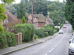
Witley Village in England

Witley is a village and civil parish in the Borough of Waverley in Surrey, England centred 2.6 miles (4 km) south west of the town of Godalming and 6.6 miles (11 km) southwest of Guildford. The land is a mixture of rural contrasting with elements more closely resembling a suburban satellite village.

Warlingham Human settlement in England

Warlingham is a village in the Tandridge district of Surrey, England, 14.2 miles (22.9 km) south of the centre of London and 22.3 miles (35.9 km) east of the county town, Guildford. Warlingham is the centre of a civil parish that includes Hamsey Green, a contiguous, smaller settlement to the north. Caterham is the nearest town, 2.0 miles (3.2 km) to the southwest.

Oxted Town and civil parish in Surrey, England

Oxted is a town and civil parish in the Tandridge district of Surrey, England, at the foot of the North Downs. It is 9 miles (14 km) south south-east of Croydon in Greater London, 8.5 miles (13.7 km) west of Sevenoaks in Kent, and 9 miles (14 km) north of East Grinstead in West Sussex.

Caterham Town in Surrey, England

Caterham is a town in the Tandridge District of Surrey, England. The town is administratively divided into two: Caterham on the Hill, and Caterham Valley, which includes the main town centre in the middle of a dry valley but rises to equal heights to the south. The town lies close to the A22, 21 miles from Guildford and 6 miles south of Croydon, in an upper valley cleft into the dip slope of the North Downs. Caterham on the Hill is above the valley to the west.

Bletchingley Human settlement in England

Bletchingley is a village in Surrey, England. It is on the A25 road to the east of Redhill and to the west of Godstone, has a conservation area with medieval buildings and is mostly on a wide escarpment of the Greensand Ridge, which is followed by the Greensand Way.

Godstone Human settlement in England

Godstone is a village and civil parish in Surrey, England, 6.3 miles (10.1 km) east of Reigate at the junction of the A22 and A25 roads, near the M25 motorway and the North Downs. Godstone railway station is separated from it by agricultural land. Blindley Heath Site of Special Scientific Interest, the Greensand Way and the North Downs Way all pass through areas of Godstone.

Limpsfield Human settlement in England

Limpsfield is a village and civil parish in Surrey, England, at the foot of the North Downs close to Oxted railway station and the A25. The composer Frederick Delius and orchestral conductor Sir Thomas Beecham are buried in the village churchyard and there are 89 listed buildings.

Woldingham Human settlement in England

Woldingham is a village and civil parish high on the North Downs between Oxted and Warlingham in Surrey, England, within the M25, 17.5 miles (28.2 km) southeast of London. The village has 2,141 inhabitants, many of whom commute to London, making Woldingham part of the London commuter belt. The village is served by the Oxted line and central London can be reached in 33 minutes by train.

Tatsfield Human settlement in England

Tatsfield is a village and civil parish in the Tandridge District of Surrey, England. It is located 3.3 miles north west of Westerham and 3.9 miles north east of Oxted, and is adjacent to the Surrey border with both Greater London and Kent.

Farleigh, Surrey Human settlement in England

Farleigh is a village in the civil parish of Chelsham and Farleigh in the Tandridge District of Surrey, England. It is located in the North Downs AONB and the Metropolitan Green Belt, 4.5 miles (7.2 km) south east of Croydon, 13.4 miles (21.6 km) south of London and 25 miles (40 km) WNE of Surrey's county town, Guildford.

Puttenham, Surrey Human settlement in England

Puttenham is a village in Surrey, England, located just south of the Hog's Back which is the narrowest stretch of the North Downs. Puttenham is about midway between the towns of Guildford and Farnham, and can be accessed from the A31 trunk road which runs along the spine of the Hog's Back. Villages nearby include Wanborough, Shackleford and Compton.

Ockley Human settlement in England

Ockley is a rural village in Surrey. It lies astride the A29, the modern road using the alignment of Stane Street (Chichester). The A29 diverges from the A24 from London about 2.5 miles northeast and takes the alignment of Stane Street a mile north of the village. It has a medieval parish church, see list of places of worship in Mole Valley.

Crowhurst, Surrey Human settlement in England

Crowhurst is a civil parish and dispersed village in a rural part of the Tandridge district of Surrey, England. The nearest town is Oxted, 3 miles (5 km) north. Rated two architectural categories higher than the medieval church is the Renaissance manor, Crowhurst Place, which is a Grade I listed building.

Horne, Surrey Rural village and civil parish in the district of Tandridge, Surrey, South East England

Horne is a rural village and civil parish in the District of Tandridge in Surrey, England. The parish includes the hamlet of Newchapel, where the British Wildlife Centre is situated. Eastern fields forming a narrow part of the parish are split by the A22 road, a main road to East Grinstead.

Nutfield, Surrey Village in England

Nutfield is a village and civil parish in the Tandridge District of Surrey, England. It lies in the Weald immediately south of the Greensand Ridge and has a railway station at South Nutfield which is one stop from Redhill, on the Redhill to Tonbridge Line. It includes a watersports park and picnic destination, Mercers Country Park.

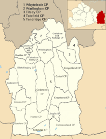
Tandridge Hundred was a hundred in Surrey, England. It comprised areas in the Tandridge District, the easternmost part of the county, bordering Kent, West Sussex and the 1965-created county of Greater London.

Chelsham Human settlement in England

Chelsham is a village in the civil parish of Chelsham and Farleigh and the Tandridge District of Surrey, England. It is located in the Metropolitan Green Belt, 15.3 miles (24.6 km) from London, 3 miles (4.8 km) from Oxted and 23.8 miles (38.3 km) from Guildford.

Tandridge Priory

Tandridge Priory was a priory in Surrey, England.

Sir John Evelyn, 1st Baronet was an English landowner in Surrey. Created a baronet at the English Restoration, he inherited the Godstone estate in 1664. He quarreled extensively with his family to obtain more money and impaired the estate with debts from a profligate lifestyle. The baronetcy became extinct upon his death and his entailed estates passed to his brother George.

References

  1. 1 2 3 Key Statistics; Quick Statistics: Population Density United Kingdom Census 2011 Office for National Statistics Retrieved 21 November 2013
  2. "Tandridge". Britannica. Retrieved 8 August 2018.
  3. Surrey Domesday Book Archived 15 July 2007 at the Wayback Machine
  4. Domesday Map Retrieved 1 December 2013
  5. 1 2 3 4 5 6 7 8 9 H.E. Malden, ed. (1912). "Parishes: Tandridge". A History of the County of Surrey: Volume 4. Institute of Historical Research. Retrieved 1 December 2013.
  6. Samuel Lewis, ed. (1848). "Tamerton-Folliott – Tapton". A Topographical Dictionary of England. Institute of Historical Research. Retrieved 1 December 2013.
  7. OS Map with Listed Buildings and Parks marked
  8. Database of British and Irish Hills Retrieved 6 March 2015
  9. St Peter's Church, Tandridge – Grade I Historic England. "Details from listed building database (1189811)". National Heritage List for England . Retrieved 1 December 2013.
  10. Pepys (Cottenham) vault – Grade II Historic England. "Details from listed building database (1294076)". National Heritage List for England . Retrieved 1 December 2013.