
Caterham and Warlingham was an Urban District of Surrey in England until 1974.
Caterham and Warlingham was an Urban District of Surrey in England until 1974.
It was pre-emptively formed shortly before the major national 1933 reforms of boundaries and entities accordingly to take account of population change, in 1929. It was a merger of the Caterham Urban District with the similar North Downs civil parish of Warlingham to the east and more rural and entirely hilltop civil parish of Woldingham from Godstone Rural District to the south-east.
In 1933 the Urban District absorbed the narrow majority, the entirely hilltop segment, of Chaldon to the west from defunct Reigate Rural District, in so doing, the contributor parish shedding 404 acres (1.63 km2) to the parish of Bletchingley and 268 acres (1.08 km2) to Coulsdon to the south and north respectively. [1]
An urban and suburban area of equal contribution between the two merged areas finally became a later civil parish after the area's abolition, Whyteleafe which had already its own railway station and church; it was throughout the district's duration identifiable as a village. [1]
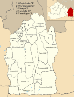
Caterham and Warlingham was abolished in 1974 due to the Local Government Act 1972 to form the north-west of the Tandridge (district) which is the easternmost part of the county and covers a much larger area, shown in red in the inset map and in grey and yellow in the main section of map. [1]

Tandridge is a local government district in east Surrey, England. Its council is based in Oxted, although the largest settlement is Caterham; other notable settlements include Warlingham, Godstone and Lingfield. In mid-2019, the district had an estimated population of 88,129.

Chigwell was a local government district in south west Essex, England. It contained the settlements of Chigwell, Loughton and Buckhurst Hill; and formed part of the Metropolitan Police District.

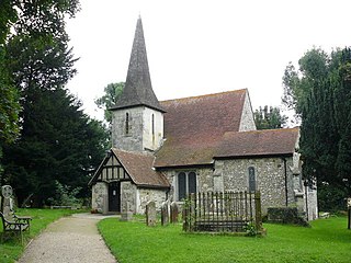
Warlingham is a village in the Tandridge district of Surrey, England, 14.2 miles (22.9 km) south of the centre of London and 22.3 miles (35.9 km) east of the county town, Guildford. Warlingham is the centre of a civil parish that includes Hamsey Green, a contiguous, smaller settlement to the north. Caterham is the nearest town, 2.0 miles (3.2 km) to the southwest.

East Surrey is a constituency represented in the House of Commons of the UK Parliament since 2019 by Claire Coutinho, a Conservative. The seat covers an affluent area in the English county of Surrey.

Caterham is a town in the Tandridge District of Surrey, England. The town is administratively divided into two: Caterham on the Hill, and Caterham Valley, which includes the main town centre in the middle of a dry valley but rises to equal heights to the south. The town lies close to the A22, 21 miles from Guildford and 6 miles south of Croydon, in an upper valley cleft into the dip slope of the North Downs. Caterham on the Hill is above the valley to the west.
Chaldon is a village and civil parish in the Tandridge District of Surrey, England. The village is situated high on the North Downs, immediately west of Caterham and 15.8 miles (25.4 km) south of Charing Cross, the traditional centre of London.

Whyteleafe is a village in the district of Tandridge, Surrey, England, with a few streets falling inside the London Borough of Croydon. The village, in a dry valley of the North Downs, has three railway stations. Neighbouring villages and towns include Woldingham, Caterham, Coulsdon, Warlingham, and Kenley. To the west are Kenley Aerodrome, Kenley Common, Coxes Wood, and Blize Wood. To the east are Riddlesdown, the Dobbin and Marden Park.

Coulsdon and Purley Urban District was a local government district in northeast Surrey from 1915 to 1965. The local authority was Coulsdon and Purley Urban District Council. The former area of the district is now mostly part of the London Borough of Croydon in Greater London, with parts in the Tandridge District and the Borough of Reigate and Banstead in Surrey.

Hornchurch was a local government district in southwest Essex from 1926 to 1965, formed as an urban district for the civil parish of Hornchurch. It was greatly expanded in 1934 with the addition of Cranham, Great Warley, Rainham, Upminster and Wennington; and in 1935 by gaining North Ockendon. Hornchurch Urban District Council was based at Langtons House in Hornchurch from 1929. The district formed a suburb of London and with a population peaking at 131,014 in 1961, it was one of the largest districts of its type in England. It now forms the greater part of the London Borough of Havering in Greater London.

Barnet was a local government district in south Hertfordshire from 1863 to 1965 around the town of Barnet.

Walton and Weybridge Urban District was a local government district in Surrey, England from 1933 to 1974.
Hazel Grove and Bramhall was a civil parish and urban district in north east Cheshire, England from 1900 to 1974.
Sutton and Cheam was a local government district in north east Surrey, England from 1882 to 1965.
Esher Urban District was an urban district in Surrey, England created by merging two urban districts and adding two parishes to the south-west. It existed from 1933 to 1974 and was governed by the elected Esher Urban District Council which shared local government functions with Surrey County Council. Its main building was the large town hall in Esher.
Chelsham and Farleigh is a civil parish in the Tandridge District of Surrey, England. The parish is high on the North Downs and centred 14 miles (23 km) south-southeast of central London and it adjoins the Greater London boundary; it is a predominantly rural/wooded parish aside from minority of land used for homes and gardens. Other than the villages of Chelsham and Farleigh, the parish also includes the hamlet of Fickleshole. The parish was created on 1 April 1969 as an amalgamation of its two named small villages.
Reigate was a hundred in what is now Surrey, England. It was geographically consonant with the southern two thirds of Borough of Reigate and Banstead together with two parishes in Tandridge and fractions of former parishes in the London Borough of Croydon and Borough of Crawley, West Sussex. Accordingly, it included the medieval-established town of Reigate with its motte castle and land which become the towns of Redhill and Horley.
Tandridge Hundred was a hundred in Surrey, England. It comprised areas in the Tandridge District, the easternmost part of the county, bordering Kent, West Sussex and the 1965-created county of Greater London.
Chelmsford Rural District was a local government district in Essex, England from 1894 to 1974. It surrounded, but did not include, the town of Chelmsford; which formed a municipal borough.

Slough was, from 1863 to 1974, a local government district in southern Buckinghamshire, England. It became an urban district in 1894 and was incorporated as a municipal borough in 1938. It was abolished in 1974 and now forms part of the borough of Slough in Berkshire.
Godstone Rural District was a rural district in Surrey, England from 1894 to 1974.