Croydon | |
---|---|
Coordinates: 51°21′22″N0°05′56″W / 51.356°N 0.099°W | |
Country | United Kingdom |
Postcode area | CR |
Postcode area name | Croydon |
Post towns | 10 |
Postcode districts | 11 |
Postcode sectors | 66 |
Postcodes (live) | 7,906 |
Postcodes (total) | 14,632 |
Statistics as at May 2020 [1] |
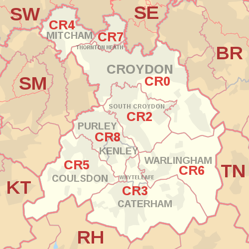
The CR postcode area, also known as the Croydon postcode area, [2] is a group of eight postcode districts in England, within ten post towns. These cover parts of southern Greater London and north-east Surrey.
The main sorting office is in Croydon, and the area served includes most of the London Borough of Croydon, the southeastern part of the London Borough of Merton and small parts of the London Boroughs of Sutton and Bromley. Most of CR3 and CR6 cover the northern part of the Tandridge district of Surrey, and the southern part of CR5 covers a small part of the borough of Reigate and Banstead.
Croydon was the second town, after Norwich, to have experimental postcodes, introduced in 1966. This trialled the postcode area CRO (letter 'O'), while Norwich used NOR for its equivalent. It was decided that the outward (first) part of a postcode should be alphanumerical, so CRO became CR0 (with a zero) and NOR became NR1. The CR1 postcode has not been introduced, making CR the only postcode area with a district 0 but not a district 1.
The CR0 postcode district covers the largest population in the UK. [3]
The approximate coverage of the postcode districts:
Delivery offices are located at Croydon, South Croydon, Caterham, Mitcham, Coulsdon, Thornton Heath and Purley. [4]
The W postcode area, also known as the London W postcode area is a group of postcode districts covering part of central and part of West London, England. The area originates from the Western (W1) and Paddington (W2-14) districts of the London postal district. This area covers 35 postcode districts and around 18,554 live postcodes.
The E (Eastern) postcode area, also known as the London E postcode area, is the part of the London post town covering much of east London, England. It borders the N postcode area to the west, both north of the tidal Thames. Since closure of the East London mail centre, its mail is sorted at Romford Mail Centre together with IG and RM postcode areas.
The RM postcode area, also known as the Romford postcode area, is a group of twenty postcode districts in south-east England, within nine post towns. These cover parts of eastern Greater London and south-west Essex. Inward mail for the area is sorted, along with mail for the E and IG postcode areas, at the Romford Mail Centre.
The IG postcode area, also known as the Ilford postcode area, is a group of eleven postcode districts in England, within six post towns. These cover parts of eastern Greater London and south-west Essex.
The EC postcode area, also known as the London EC postal area, is a group of postcode districts in central London, England. It includes almost all of the City of London and parts of the London boroughs of Islington, Camden, Hackney, Tower Hamlets and Westminster. The area covered is of very high density development. Deliveries for the EC postcode area are made from Mount Pleasant Mail Centre.
The WC postcode area, also known as the London WC postcode area, is a group of postcode districts in central London, England. The area covered is of high density development, and includes parts of the City of Westminster and the London Boroughs of Camden and Islington, plus a very small part of the City of London.
The KT postcode area, also known as the Kingston upon Thames postcode area, is a group of 24 postcode districts in England, within 19 post towns. These cover boroughs in south-west Greater London and several boroughs in north-east Surrey.
The SM postcode area, also known as the Sutton postcode area, is a group of seven postcode districts in England, within five post towns. These cover part of south-west London, as well as a small part of north Surrey.
The EN postcode area, also known as the Enfield postcode area, is a group of eleven postcode districts in England, within seven post towns. These cover parts of northern Greater London, southern Hertfordshire and western Essex.
The BR postcode area, also known as the Bromley postcode area, is a group of eight postcode districts in England, within seven post towns. These cover part of south-eastern Greater London, as well as a small part of north-west Kent.
The TW postcode area, also known as the Twickenham postcode area, is a group of twenty postcode districts in south-east England, within thirteen post towns. These cover parts of south-west London and north-west Surrey, plus a very small part of Berkshire.
The DA postcode area, also known as the Dartford postcode area, is a group of eighteen postcode districts in England, within eleven post towns. These cover parts of south-east London and north-west Kent.
The UB postcode area, also known as the Southall postcode area, is a group of eleven postcode districts in England, within six post towns. These cover parts of western and north-western Greater London, plus a very small part of Buckinghamshire. The letters in the postcodes are the phonemic abbreviation of Uxbridge.
The HA postcode area, also known as the Harrow postcode area, is a group of ten postcode districts in England, within seven post towns. These cover part of northwest London, plus a very small part of south Hertfordshire.
The WD postcode area, also known as the Watford postcode area, is a group of eleven postcode districts in Greater London and Hertfordshire, within seven post towns. These cover south-west Hertfordshire, plus very small parts of Buckinghamshire and the London Borough of Hillingdon.
The BL postcode area, also known as the Bolton postcode area, is a group of ten postcode districts in North West England. These cover most of the Metropolitan Borough of Bolton and the northern and central parts of the Metropolitan Borough of Bury in Greater Manchester, plus small parts of the boroughs of Chorley, Rossendale and Blackburn with Darwen in Lancashire.
The RH postcode area, also known as the Redhill postcode area, is a group of twenty postcode districts in South East England, within seventeen post towns. These cover east Surrey and northeastern West Sussex plus small parts of northwestern East Sussex.
The TN postcode area, also known as the Tunbridge Wells postcode area, is a group of 40 postcode districts in England, within 24 post towns. These cover south and west Kent and northern and eastern East Sussex, plus very small parts of Surrey and the London Borough of Bromley.
The SW postcode area, also known as the London SW postcode area, is a group of 20 postcode districts within the London post town in England. The area comprises the South Western operational district and the Battersea operational district, and is the only area within the London post town to lie on both sides of the River Thames.
{{cite web}}
: CS1 maint: bot: original URL status unknown (link)