HS postcode area

Last updated

Template:Attached KML/HS postcode area
KML is from Wikidata
Outer Hebrides
United Kingdom adm location map.svg
Red pog.svg
HS
Coordinates: 57°58′01″N6°42′43″W / 57.967°N 6.712°W / 57.967; -6.712
CountryUnited Kingdom
Postcode area
HS
Postcode area name
Outer Hebrides
Post towns 8
Postcode districts 9
Postcode sectors11
Postcodes (live)962
Postcodes (total)1,093
Statistics as at May 2020 [1]

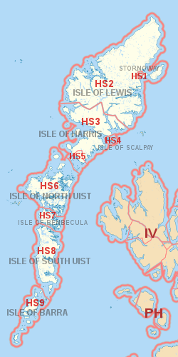
The HS postcode area, also known as the Outer Hebrides postcode area, [2] is a group of nine postcode districts, within eight post towns, covering the Outer Hebrides in Scotland.

Contents

It is the UK's newest postcode area, the Outer Hebrides formerly being part of the PA postcode area (forming PA80 - PA87 until January 1995).

Coverage

The approximate coverage of the postcode districts:

Postcode district Post town CoverageLocal authority area(s)
HS1STORNOWAY Stornoway (immediate area), Plasterfield Comhairle nan Eilean Siar
HS2ISLE OF LEWISSettlements in Lewis outside the Stornoway area including
Back, Carloway, Ness, North Lochs, Park (South Lochs), Point, Uig and West Side
HS3ISLE OF HARRISHarris excluding Leverburgh and Rodel area
HS4ISLE OF SCALPAYAll settlements
HS5ISLE OF HARRIS Leverburgh, Rodel
HS6ISLE OF NORTH UISTAll settlements
HS7ISLE OF BENBECULAAll settlements
HS8ISLE OF SOUTH UISTAll settlements
HS9ISLE OF BARRAAll settlements, including Mingulay

Map

Template:Attached KML/HS postcode area
KML is from Wikidata
HS postcode area map, showing postcode districts in red and post towns in grey text, with links to nearby IV and PH postcode areas. HS postcode area map.svg
HS postcode area map, showing postcode districts in red and post towns in grey text, with links to nearby IV and PH postcode areas.

See also

Related Research Articles

The NP postcode area, also known as the Newport postcode area, is a group of eighteen postcode districts, which are subdivisions of fourteen post towns. These cover south-east Wales, including Newport, Pontypool, Abergavenny, Monmouth, Chepstow, Abertillery, Usk, Tredegar, New Tredegar, Ebbw Vale, Crickhowell, Blackwood, Caldicot and Cwmbran, plus a small part of the English counties of Gloucestershire and Herefordshire.

The DE postcode area, also known as the Derby postcode area, is a group of 23 postcode districts in central England, within 11 post towns. These cover south and central Derbyshire, parts of east Staffordshire and north-west Leicestershire, and very small parts of Nottinghamshire.

The HP postcode area, also known as the Hemel Hempstead postcode area, is a group of twenty-four postcode districts in England, within eleven post towns. These cover north-west Hertfordshire and central Buckinghamshire.

The LN postcode area, also known as the Lincoln postcode area, is a group of thirteen postcode districts in England, which are subdivisions of seven post towns. These cover central Lincolnshire, including Lincoln, Alford, Horncastle, Louth, Mablethorpe, Market Rasen and Woodhall Spa.

The LU postcode area, also known as the Luton postcode area, is a group of seven postcode districts in England, within three post towns. These cover south Bedfordshire, plus small parts of north Hertfordshire and east Buckinghamshire.

The MK postcode area, also known as the Milton Keynes postcode area, is a group of 26 postcode districts in England, within five post towns. These cover north Buckinghamshire, west and north Bedfordshire and very small parts of Northamptonshire, Oxfordshire and Cambridgeshire.

The YO postcode area, also known as the York postcode area, is a group of 29 postcode districts in Yorkshire, England, within ten post towns. These cover most of Central and Eastern North Yorkshire and the northern part of the East Riding of Yorkshire. The rest of North Yorkshire is split between the TS, DL, LA, BD, HG, DN and WF postcode areas.

The SK postcode area, also known as the Stockport postcode area, is a group of nineteen postcode districts in England, within eleven post towns. These cover south-east Greater Manchester, parts of east Cheshire, north-west Derbyshire and a small part of north Staffordshire.

The CW postcode area, also known as the Crewe postcode area, is a group of twelve postcode districts in England, within eight post towns. These cover much of Cheshire, including Crewe, Northwich, Congleton, Middlewich, Nantwich, Sandbach, Tarporley and Winsford, plus very small parts of Staffordshire and Shropshire.

The NN postcode area, also known as the Northampton postcode area, is a group of nineteen postcode districts in England, within eight post towns. These cover most of Northamptonshire, plus very small parts of Bedfordshire, Buckinghamshire, Leicestershire, Oxfordshire and Warwickshire.

The LS postcode area, also known as the Leeds postcode area, is a group of 29 postcode districts in England, within six post towns. These cover northern West Yorkshire and some parts of North Yorkshire.

The HU postcode area, also known as the Hull postcode area, is a group of twenty postcode districts in England, within eight post towns. These cover the south of the East Riding of Yorkshire, including Hull, Beverley, Cottingham, Hessle, Hornsea, Withernsea, Brough and North Ferriby.

The HD postcode area, also known as the Huddersfield postcode area, is a group of nine postcode districts in England, within three post towns. These cover southern West Yorkshire, including Huddersfield and Holmfirth in the Metropolitan Borough of Kirklees, and Brighouse in the Metropolitan Borough of Calderdale.

The BD postcode area, also known as the Bradford postcode area, is a group of 24 postcode districts in England, within seven post towns. These cover northwestern West Yorkshire and southwestern North Yorkshire, plus very small parts of Lancashire.

The SP postcode area, also known as the Salisbury postcode area, is a group of eleven postcode districts in southern England, within six post towns. These cover south Wiltshire and parts of north Dorset and west Hampshire.

The ST postcode area, also known as the Stoke-on-Trent postcode area, is a group of 21 postcode districts in England, within six post towns. These cover much of north and central Staffordshire, plus very small parts of Cheshire and Derbyshire.

The PA postcode area, also known as the Paisley postcode area, is a group of 67 postcode districts in western Scotland, within 35 post towns. These cover Renfrewshire, Inverclyde and most of Argyll and Bute, plus small parts of North Ayrshire and Highland.

The CT postcode area, also known as the Canterbury postcode area, is a group of 21 postcode districts in South East England, within 13 post towns. These cover much of east Kent, including Canterbury, Dover, Folkestone, Birchington, Broadstairs, Deal, Herne Bay, Hythe, Margate, Ramsgate, Sandwich, Westgate-on-Sea and Whitstable.

The TF postcode area, also known as the Telford postcode area, is a group of thirteen postcode districts in England, within six post towns. These cover north-east Shropshire, including Telford, Broseley, Market Drayton, Much Wenlock, Newport and Shifnal, plus a small part of west Staffordshire.

The HR postcode area, also known as the Hereford postcode area, is a group of nine postcode districts in England and Wales, which are subdivisions of six post towns. These cover most of Herefordshire, including Hereford, Bromyard, Kington, Ledbury, Leominster and Ross-on-Wye, while the HR2, HR3 and HR5 districts extend across the border to cover a small part of Powys.

References

  1. "ONS Postcode Directory Version Notes" (ZIP). National Statistics Postcode Products. Office for National Statistics. May 2020. Table 2. Retrieved 19 June 2020. Coordinates from mean of unit postcode points, "Code-Point Open". OS OpenData. Ordnance Survey. February 2012. Retrieved 21 April 2012.
  2. Royal Mail, Address Management Guide, (2004)