Until the 1930s, the area now known as New Addington was farmland and woodland in the southeast of the ancient parish of Addington. The farms were called Castle Hill, Addington Lodge (later Fisher's Farm).[2] At the time, central Croydon and London more generally had overcrowded slums causing concern to the authorities. In 1935, the First National Housing Trust purchased 569 acres (2.30km2) of Fisher's Farm with the intention of erecting a 'Garden Village', with 4,400 houses, shops, two churches, cinema, and village green.[3] The Chairman of the Trust was Charles Boot, hence the earliest part of New Addington is sometimes called The Boot's Estate.[2]
By 1939, when the outbreak of World War II suspended construction, 1,023 houses and 23 shops had been built. The new estate was popular, but the provision of amenities had not kept pace with the house building. Only one of the proposed schools and few of the shops were in operation. For employment, decent shopping and entertainment, the residents had to travel off the estate. This heralded a long history of isolation for the estate, then nicknamed Little Siberia, because it is much colder than the rest of Croydon.[citation needed] The isolation was partly remedied 60 years later with the arrival of Tramlink route 3, mentioned below.[3] Tramlink runs alongside Lodge Lane, the main (northern) road access. There is only one other point of access by road, where King Henry's Drive connects with minor roads to the south.
After the war, there were concerns about the amount of green space being used for building around London and much of the countryside around the developing estate was designated as Green Belt land.[3] The County Borough of Croydon bought the unused First National Housing Trust land and a further 400 acres (1.6km2) to add to it, for extensive further development.[3] Many dozens of single-storey, detached, prefabricated houses (commonly known as "prefabs" of the "Arcon" type using corrugated cement asbestos panels fixed to a bolted steel frame as photographed in "A 1950s metal UK prefab at the Rural Life Centre, Tilford, Surrey.") were built in the Castle Hill area of the estate. These were inhabited until the 1960s when they were demolished and replaced with brick-built two-storey homes.[citation needed] At the same time as the smaller prefabs were built, larger two-storey semi-detached houses were also built. These houses, which had metal upper skins, still survive around the King Henry's Drive area near Wolsey School. This was more development than had originally been envisaged but it brought about the structure of the estate as seen today.
Many more houses, blocks of flats, churches, factories and Central Parade with its shops, were built. The London Borough of Croydon obtained permission for a further 1,412 houses, which were completed in 1968.[3] This area, at the Croydon end, is known as the Fieldway Estate and has developed its own identity to an extent.[2] The total population counted by the 2011 Census was 22,280, of which 10,801 were in New Addington ward, with 11,479 in Fieldway ward.[citation needed]
Reputation
Map of New Addington, showing its distance from other Croydon settlements
The distance from Croydon and other centres, with patchy bus services being the only main transport links for many years, prevented New Addington residents from being able to access a full range of employment and educational facilities or indeed shops. A significant improvement was the arrival of Tramlink (route 3) in 2000, providing a connection with Croydon and Wimbledon in a little over 30 minutes, and from there connections to Central London. This provided the opportunity of a greater choice of schools and jobs. Several 'feeder' 'bus routes were also introduced to connect with Tramlink, along with general enhancement to bus services in the area. The area was declared[when?] one of the first Education Action Zones by the Labour government, with extra investment and opportunities for partnership for schools.[citation needed] The London Borough of Croydon increased its investment in the remaining housing stock and in the leisure and youth facilities.[3] It also organised a neighbourhood partnership for the estate which local people lead to hold public institutions to account.[citation needed]
New Addington has however continued to suffer from various reports of violence and public upset for several years, reflecting upon anti-social behaviour and gang violence involving youths on the estate from the 1970s to the present, as well as the perceived poor standard of schools, low educational and health standards, and a reported high number of teenage mothers, particularly in Fieldway.[citation needed] In a Croydon Advertiser survey in 2013, New Addington, in comparison with other areas, was said to be the worst in Croydon to live, based on life expectancy, incapacity benefit claimants rates and income support, unemployment, crime, school exam passes, public transport accessibility and access to open space and nature.[4]
The area was affected during the 2011 England Riots. A supermarket was destroyed by firebombs and stolen property was found in the area.[5][6] An inquiry supported the provision of a local police station.[7] A councillor praised local recovery from the riots, claiming the area was now a stronger community than before and rates of anti-social behaviour were beginning to decline.[8]
The Fieldway estate came under criticism in 2011, following local resident Emma West being arrested and charged with a racially aggravated public order offence, weeks after a video was uploaded to YouTube of her racially abusing passengers on the Croydon Tramlink, attracting 11 million viewers by 2012.[9][10] Her detainment on remand at HMP Bronzefield attracted a protest from the Britain First movement.[11] On 1 July 2013 she was sentenced to 24 months' community service and ordered to be put under a supervision order, as well as receive mental health treatment.[12]
The estate was also the scene of the disappearance and death of 12 year-old Tia Sharp in 2012.[13] Residents of New Addington rejected comments from journalists who they felt inaccurately cited her death as an example in reflecting the area's issues.[14][15][16]
In 2013, the area was featured three times in the same episode of Crimewatch UK, predominantly focusing on the area's gang culture.[17]
The most common household tenure were those rented from council (31% of households), followed by 29% of homes owned by a mortgage or loan. 7% of the economically active population were unemployed. The median age of the population is 34.[19]
0.3% of the population (as well as Fieldway ward) commuted to work by bicycle, the second lowest in Greater London and only higher than Kenton East in Harrow.[20]
Politically, New Addington has traditionally been a Labour stronghold, providing the only five Labour councillors out of 70 in the London Borough of Croydon between 1982 and 1986.[citation needed] Four of the last six leaders of the Labour Party on Croydon Council have been councillors representing the estate, including Geraint Davies, the area's former Member of Parliament, and Val Shawcross, now a London Assembly member.
From 1965 to 1978 the area was covered by one ward, New Addington. The population of New Addington increased following the construction of the Fieldway estate and it was split into two wards ahead of the 1978 Croydon Council election, New Addington, which now covered the southern end of the New Addington area and Fieldway which covered the northern end of New Addington area and the Fieldway estate itself. The boundaries were modified slightly ahead of the 2002 Croydon Council election.
In 2006 the two ward had two Labour councillors each, both wards seeing strong challenges from the BNP.[citation needed] In the 2010 local elections, New Addington ward elected Tony Pearson, its first Conservative Councillor since 1968.[citation needed]
In 2018, following a boundary review, New Addington ward was renamed New Addington South and Fieldway ward was renamed New Addington North with minor adjustments to their boundaries.[25] The Conservatives missed out on winning a seat in New Addington South by 180 votes, with Labour once again holding all four seats.[citation needed]
In 2022, however, the Conservatives won both council seats in New Addington South and one of the seats in New Addington North, with Labour winning the other.
Facilities
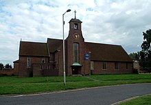
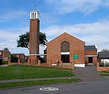
St Edward the Confessor's Church, New AddingtonChurch of the Good Shepherd, New Addington
The Anglican parish church of New Addington is St Edward's Church[26] at the end of Central Parade, built in 1957. Fieldway, however, is part of Addington parish, under the 11th century St Mary the Blessed Virgin Church in Addington village. There are also a Baptist church, the Good Shepherd Roman Catholic Church, the Salvation Army and several other smaller places of worship.
Although most of the rest of Croydon has the London telephone dialling code '020', New Addington has the Orpington code for BT customers of '01689'. In recent years, cable telephone providers have entered the estate, using 020 for completely new customers, but existing BT customers transferring over to cable can retain the 01689 number if they so wish.[citation needed] New Addington is in the CR0 postal district, the largest (by population) in the country.[27]
Since the beginning of 2006, Croydon Council have started a consultation with the local community with a view to regenerating the Central Parade shopping district and bringing in a partner to develop new housing and a supermarket retail outlet.[citation needed]
Transport
Rail
The nearest National Rail stations to New Addington are Hayes, located 3.6 miles away, and East Croydon, located 5 miles away.
Tramlink, previously Croydon Tramlink and presently branded as London Trams, is a light rail tram system serving Croydon and surrounding areas in South London, England. It is the first operational tram system serving the London region since 1952. Tramlink is presently managed by London Trams, a public body part of Transport for London (TfL), and has been operated by FirstGroup since 2017. It is one of two light rail networks in Greater London, the other being the Docklands Light Railway. Tramlink is the fourth-busiest light rail network in the UK behind the Docklands Light Railway, Manchester Metrolink and Tyne and Wear Metro.
The London Borough of Croydon is a London borough in south London, part of Outer London. It covers an area of 87 km2 (33.6 sq mi). It is the southernmost borough of London. At its centre is the historic town of Croydon from which the borough takes its name; while other urban centres include Coulsdon, Purley, South Norwood, Norbury, New Addington, Selsdon and Thornton Heath. Croydon is mentioned in Domesday Book, and from a small market town has expanded into one of the most populous areas on the fringe of London. The borough is now one of London's leading business, financial and cultural centres, and its influence in entertainment and the arts contribute to its status as a major metropolitan centre. Its population is 390,719, making it the most populous London borough and sixteenth largest English district.
Addington is a village and area in south London, England, within the London Borough of Croydon. It is south of Spring Park, west of Coney Hall, north of New Addington and east of Forestdale and Selsdon, and is 11.1 miles (18 km) south of Charing Cross and 4 miles (6.4 km) south-east of the centre of Croydon.
Waddon is a neighbourhood in the London Borough of Croydon, at the western end of the town of Croydon. The area borders the London Borough of Sutton.
Croydon is a large town in South London, England, 9.3 miles (15.0 km) south of Charing Cross. Part of the London Borough of Croydon, a local government district of Greater London, it is one of the largest commercial districts in Greater London, with an extensive shopping district. The entire town had a population of 192,064 as of 2011, whilst the wider borough had a population of 384,837.
Coombe is a place in the London Borough of Croydon, situated south-east of central Croydon, between Addiscombe, Selsdon and Upper Shirley. Formerly a hamlet, since the growth of suburban development the area has become swallowed into the London conurbation and often does not appear on modern map.
Forestdale is a residential neighbourhood of southeast London in the London Borough of Croydon. It is sometimes considered to be part of Addington, its ancient and ecclesiastical parish. It is located south of Upper Shirley, east of Selsdon, south-west of Addington's historic centre, north-west of New Addington and north of Farleigh and is east of West Wickham.
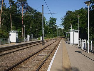
Fieldway tram stop is a light rail stop serving the Fieldway residential area of New Addington, located in the London Borough of Croydon. It is adjacent to a northbound bus stop on the A2022 Lodge Lane.
Centrale tram stop is a stop on the Tramlink service in Croydon town centre, serving the Centrale shopping centre. The tram stop was provided and paid for as part of the development of the shopping centre.
Addington Village Interchange is a light rail stop and associated bus station serving Addington in the London Borough of Croydon in the southern suburbs of London. It opened on 10 May 2000 along with the line to New Addington.
New Addington is a terminal tram stop serving the centre of New Addington, located in the London Borough of Croydon. The tram stop is served by London Trams, which connects New Addington with central Croydon.
Coombe Lane tram stop is a light rail stop in the London Borough of Croydon in the southern suburbs of London. It is located in Coombe, south of Addington Hills and serves Royal Russell School and the Ballards residential estate.
Pollards Hill is a small residential district straddling the south London boroughs of Croydon and Merton between Mitcham, Norbury and Thornton Heath. The boundary of the two boroughs is a street named Recreation Way. No roads directly cross the Croydon/Merton divide, and streets were planned according to each borough, leading to differing architectural or building schemes. Pollards Hill lends its name to a ward of the London Borough of Merton.
Sandilands tram stop is a light rail stop in the London Borough of Croydon in the southern suburbs of London. It serves the residential area along Addiscombe Road to the east of the centre of the town of Croydon. The tram stop gets its name from the nearby Sandilands Tunnel.
Gravel Hill tram stop is a light rail stop serving Addington, in the London Borough of Croydon in the southern suburbs of London. It is the main destination for tourists visiting the historic site of Addington Palace. It is also used by students who attend John Ruskin College and is the nearest stop for Forestdale.
King Henry's Drive tram stop is a tram stop serving the Betchworth Way residential area of New Addington, located in the London Borough of Croydon. It is located in the wide central reservation of a dual carriageway.
St George's Walk is a partially covered shopping parade in the centre of Croydon, London that houses many independent stores. It was completed in 1964 by Ronald Ward and Partners, the designers of St George's House, at one end of the walk, and Millbank Tower in Westminster.
Croydon, located in Greater London, England, has a diverse economy with the service and retail sectors now dominating over the town's historical market status.
New Addington North is a ward in the London Borough of Croydon, covering part of the New Addington estate in London in the United Kingdom. The ward currently forms part of the Croydon East constituency.
Ashburton was a ward in the London Borough of Croydon, in London in the United Kingdom. The ward covered the Ashburton area, as well as covering the main retail area of Addiscombe, the Stroud Green, Tollgate and Longheath Garden estates, and large parts of northern Shirley. The population of the ward at the 2011 Census was 14,721.
This page is based on this Wikipedia article Text is available under the CC BY-SA 4.0 license; additional terms may apply. Images, videos and audio are available under their respective licenses.