Ashburton Park

Last updated

Ashburton Park
Ashburton park petanque terrain (12562292033).jpg
Ashburton Park pétanque terrain
Ashburton Park
Type Park
Location Woodside
Nearest city London Borough of Croydon, UK
Coordinates 51°23′07″N0°04′02″W / 51.38519°N 0.06709°W / 51.38519; -0.06709 Coordinates: 51°23′07″N0°04′02″W / 51.38519°N 0.06709°W / 51.38519; -0.06709
Area18.5 acres (7.5 ha)
Created1924
OpenAll year (closed at night)

Ashburton Park is a park located in Woodside, in the London Borough of Croydon, and takes its name from nearby Ashburton.

Contents

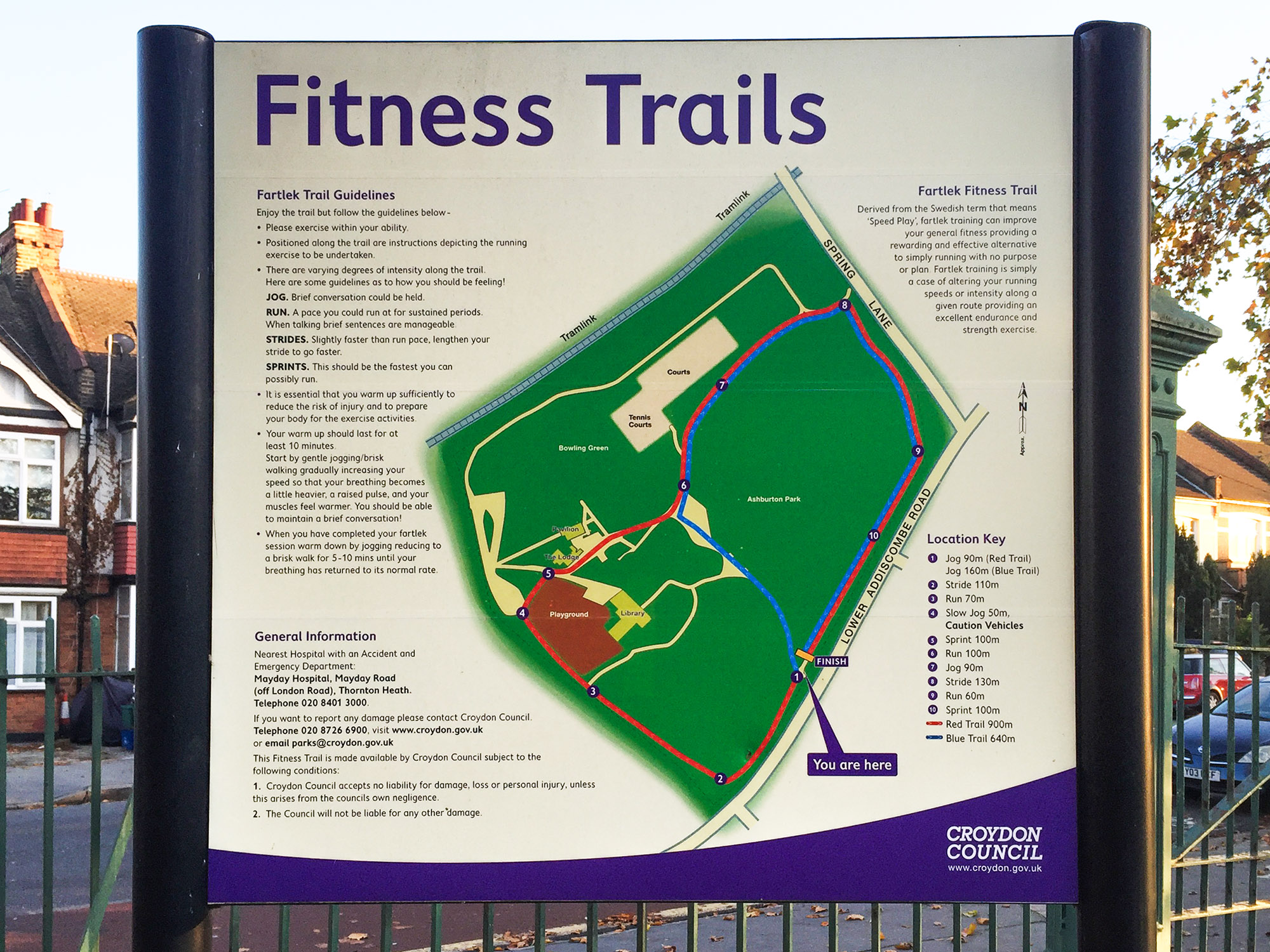
The park is located close to Woodside tram stop, where Tramlink services the park. It is on the junction of Lower Addiscombe Road and Spring Lane. The park covers an area of 18.5 acres (7.5 ha) [1] and includes a village green, pétanque terrain, bowling green, tennis and basketball courts and a café.

History

The site was once the location of Woodside Convent, [2] and the property has changed hands many times since then. A mansion was built on the site in 1788. [2] Croydon Corporation bought the house and grounds by Compulsory Purchase Order in 1924. [2] Most of the buildings were torn down, with a putting green (no longer there) being laid on the site. [2] The only remaining part of the house was the c. 1878 extension which became Ashburton Library. [3] The library was relocated in 2006–2007 to the nearby Ashburton School and the building fell into disrepair. [3]

Despite the neglect of the café and former library building the local council have spent some money on renovating the public toilets, improving the children's playing park and adding some features for joggers and fun runners on the perimeter paths. [4]

The Friends of Ashburton Park group, launched in September 2013, have come together to put the former library back into community use. [3]

In December 2017, the park was due to host the Croydon Winter Festival, with seasonal events including ice-skating. [5]

See also

Related Research Articles

London Borough of Croydon Borough in United Kingdom

The London Borough of Croydon is a London borough in south London, part of Outer London. It covers an area of 87 km2 (33.6 sq mi). It is the southernmost borough of London. At its centre is the historic town of Croydon from which the borough takes its name; while other urban centres include Coulsdon, Purley, South Norwood, Norbury, New Addington and Thornton Heath. Croydon is mentioned in Domesday Book, and from a small market town has expanded into one of the most populous areas on the fringe of London. The borough is now one of London's leading business, financial and cultural centres, and its influence in entertainment and the arts contribute to its status as a major metropolitan centre.

Crystal Palace, London Residential area in London, England

Crystal Palace is an area in south London, England, named after the Crystal Palace Exhibition building which stood in the area from 1854 until it was destroyed by fire in 1936. Approximately 7 miles (11 km) south-east of Charing Cross, it includes one of the highest points in London, at 367 feet (112 m), offering views over the capital. The area has no defined boundaries and straddles five London boroughs and three postal districts, although there is a Crystal Palace electoral ward and Crystal Palace Park in the London Borough of Bromley. It is contiguous with Anerley, Dulwich Wood, Gipsy Hill, Penge, South Norwood, Sydenham and Upper Norwood.

Monks Orchard Human settlement in England

Monks Orchard is a suburb on the edge of the London Borough of Croydon, England, historically located in Surrey. It is situated about 10 miles (16.1 km) south south-east of Charing Cross, south of Elmers End and Eden Park, west of West Wickham, and north and east of Shirley and Shirley Oaks.

South Norwood District of south east London, England

South Norwood is a district of south-east London, England, within the London Borough of Croydon and the historic county of Surrey. It is located 7.8 miles (12.5 km) south-east of Charing Cross, north of Woodside and Addiscombe, east of Selhurst and Thornton Heath, south of Crystal Palace/Upper Norwood and Anerley, and west of Elmers End and Penge.

Parks and open spaces in the London Borough of Croydon

The London Borough of Croydon has over 120 parks and open spaces within its boundaries, ranging from the 200 acre (80ha) Selsdon Wood Nature Reserve to many recreation grounds and sports fields scattered throughout the Borough. Croydon covers an area of 86.52 km², the 256th largest district in England. Croydon's physical features consist of many hills and rivers that are spread out across the borough and into the North Downs, Surrey and the rest of South London. Some of the open spaces in Croydon form part of the well-known London LOOP walks where the first section was opened on 3 May 1996 with a ceremony on Farthing Downs in Coulsdon. As a borough in Outer London it also contains some open countryside in the form of country parks. Croydon Council is associated with several other boroughs who are taking part in the Downlands Countryside Management Project. These boroughs are Sutton; and by Surrey County Council; the City of London Corporation; the Surrey districts of Reigate and Banstead and Tandridge; and the Countryside Agency. An additional partner is Natural Britain.

Woodside, London Human settlement in England

Woodside is an area in south London, located in the London Borough of Croydon and the historic county of Surrey. located between Addiscombe and South Norwood. It is located south of South Norwood, west of Shirley and Monks Orchard, north of Addiscombe, and east of Selhurst.

Woodside Green

Woodside Green is a green space and street located in Woodside, London. The station is located near to Woodside tram stop in the London Borough of Croydon. The green is over 4.75 acres (1.92 ha).

Woodside tram stop

Woodside tram stop is a light rail stop situated between Woodside Green and Ashburton Park in the London Borough of Croydon in the southern suburbs of London. The stop is located on the site of the former Woodside railway station of the Woodside and South Croydon Railway; the old station buildings survive, though not used by Tramlink.

A215 road Road in London, England

The A215 is an A road in south London, starting at Elephant and Castle and finishing around Shirley. It runs through the London Boroughs of Lambeth, Southwark and Croydon.

South Norwood Recreation Ground

South Norwood Recreation Ground is a park located in South Norwood in the London Borough of Croydon. In 1889, Croydon Corporation acquired the land and the borough surveyor estimated that it would cost just over £1,300 to lay out. Over a quarter of the projected cost was to install land drainage, which indicates that the site was quite wet. The recreation ground includes a sports area, football pitches, tennis court, floodlit courts, bowling green with pavilion and a children's playground.

Heavers Meadow

Heavers Meadow is a meadow located in South Norwood and Selhurst in the London Borough of Croydon. South Norwood Recreation Ground is on the other side of the road. The meadow covers an area of 8​34 acres. With meadows there are not usually many facilities. Heavers is no exception; the only facility stated on the council's website is a footpath through a flood meadow.

Brickfields Meadow Meadow in Croydon, London

Brickfields Meadow is a meadow in South Norwood in the London Borough of Croydon. It is located on the former site of a brickworks in Tennison Road and Dickensons Lane in Woodside. The meadow covers an area of about 4.37 hectares. The meadow is not very well known to residents on Tennison Road, as the entrance is very secluded, beyond an EDF Energy transformer. The meadow includes: large pond where fishing is allowed, dipping platform, Buddleia Valley, grassland and woodland planting, small woodland area, and a children's play area which includes a mini maze and roundabout.

South Norwood Lake and Grounds

South Norwood Lake and Grounds is a park in South Norwood in the London Borough of Croydon. The main entrance is in Woodvale Avenue while other entrances are located in Auckland Road and Sylvan Road. The area measures up to 28​12 acres.

Addington Park

Addington Park is a park situated in Addington in the London Borough of Croydon. The park covers an area of 24.5 acres (9.9 ha).

Ashburton Playing Fields

Ashburton Playing Fields is a playing field located in Woodside, London. It is managed by the London Borough of Croydon. The fields are bordered by Bywood Avenue in the north, Chaucer Green in the west and Woodville Avenue in the east. Stroud Green Way backs onto the western boundary. Tramlink services for the park are Arena and Woodside. It covers an area of 49.5 acres (20 ha).

Ashburton Learning Village is a learning complex in Woodside, Greater London. It stands in the London Borough of Croydon, and is located near Ashburton Park. The learning village includes Ashburton Library, Oasis Academy Shirley Park, Croydon Music Service and a CALAT training centre. The complex was built after the old Ashburton Library was closed down. The nearest Tramlink stop is Woodside. The centre is earmarked as Croydon's Flagship Learning Village.

Architecture of the London Borough of Croydon

The London Borough of Croydon has a wide variety of buildings mainly from post-war through to modern. Much of the modern architecture in the borough is centred on the commercial centre of the town, with much of the Victorian designs spread out on both the northern and southern corridors of the borough. Many former warehouses and factories have been converted for other uses changing the external appearance of Croydon erratically.

Ashburton (ward)

Ashburton was a ward in the London Borough of Croydon, in London in the United Kingdom. The ward covered the Ashburton area, as well as covering the main retail area of Addiscombe, the Stroud Green, Tollgate and Longheath Garden estates, and large parts of northern Shirley. The population of the ward at the 2011 Census was 14,721.

References

  1. "Ashburton Park". London Borough of Croydon. 19 November 2014. Retrieved 5 June 2020.
  2. 1 2 3 4 Winterman, M.A. (1988). Croydon's Parks: An illustrated history. London Borough of Croydon, Parks and Recreation Department. pp. 9–10. ISBN   0951348108.
  3. 1 2 3 "Friends of Ashburton Park" . Retrieved 5 June 2020.
  4. "Fitness Trails". Friends of Ashburton Park. Retrieved 21 November 2020.
  5. "Croydon Winter Festival, Ashburton Park, Dec 8-Jan 2". insidecroydon.com. 24 October 2017. Retrieved 20 November 2017.