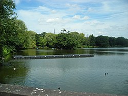
South Norwood Lake and Grounds

Last updated

South Norwood Lake and Grounds
South Norwood Lake.JPG
South Norwood Lake
South Norwood Lake and Grounds
TypePublic park
Location South Norwood
Operated by London Borough of Croydon
StatusOpen all year
Public transit access410 bus to Harris City Academy stop

South Norwood Lake and Grounds is a park in South Norwood in the London Borough of Croydon. The main entrance is in Woodvale Avenue while other entrances are located in Auckland Road and Sylvan Road. The area measures up to 2812 acres (11.53 hectares). [1]

Contents

As well as the lake, there is a bowling green, tennis and basketball courts, football pitches, a cricket pitch, a playground and a trim trail. The park has active park rangers and has a park ranger's office with adjoining public toilets.

The lake was originally created as a reservoir for the Croydon Canal, which, from 1809 to 1836, ran between Croydon and the Grand Surrey Canal at New Cross. [2] As of May 2019, it is used by local anglers, who fish for carp, bream and perch among others, and Croydon Sailing Club. The lake is also home to a variety of aquatic birds including a number of great crested grebes as well as regularly sighted herons and ring-necked parakeets that can be seen nesting on the island.

In 2004, blue green algae resulted in the death of significant numbers of fish, and the predominant species left were carp and perch. [3] The lake itself has natural food sources for fish including a blood worm bar.

Norwood Sports Club

Dinghy sailing on Norwood Lake Norwood Lake (Sailing).jpg
Dinghy sailing on Norwood Lake

The grounds are also home to the Norwood Sports Club. Founded in 1881 by Alfred Steer, the club leased 16 acres which included the lake and in 1888 a further 37 acres were leased from the Ecclesiastical Commissioners. [4] At that point the club was the largest tennis club in the world with 54 courts. [4] Facilities then included bowls, tennis, cricket and golf as well as the lake. The golf course was requisitioned during World War I and was damaged and fell into disuse thereafter. [4] The grounds were used by British Dominion Insurance as a staff sports ground from 1920, [4] before the original 16 acres were purchased by Croydon Council in 1931. [4] The additional 37 acres were firstly leased in 1933 and subsequently purchased in 1936, by the council. The sports club leased most of the land until 1947 when 33.5 acres were relinquished. The grounds were opened fully to the public in 1969 but the club still retains some user rights. [4]

See also

Related Research Articles

<span class="mw-page-title-main">Coombe, Croydon</span> Human settlement in England

Coombe is a place in the London Borough of Croydon, situated south-east of central Croydon, between Addiscombe, Selsdon and Upper Shirley. Formerly a hamlet, since the growth of suburban development the area has become swallowed into the London conurbation and often does not appear on modern map.

<span class="mw-page-title-main">South Norwood</span> District of south east London, England

South Norwood is a district of south-east London, England, within the London Borough of Croydon, Greater London and formerly in the historic county of Surrey. It is located 7.8 miles (12.5 km) south-east of Charing Cross, north of Woodside and Addiscombe, east of Selhurst and Thornton Heath, south of Crystal Palace/Upper Norwood and Anerley, and south-west of Penge.

<span class="mw-page-title-main">Parks and open spaces in the London Borough of Croydon</span>

The London Borough of Croydon has over 120 parks and open spaces within its boundaries, ranging from the 200 acre (80ha) Selsdon Wood Nature Reserve to many recreation grounds and sports fields scattered throughout the Borough. Croydon covers an area of 86.52 km2, the 256th largest district in England. Croydon's physical features consist of many hills and rivers that are spread out across the borough and into the North Downs, Surrey and the rest of South London. Some of the open spaces in Croydon form part of the well-known London LOOP walks where the first section was opened on 3 May 1996 with a ceremony on Farthing Downs in Coulsdon. As a borough in Outer London it also contains some open countryside in the form of country parks. Croydon Council is associated with several other boroughs who are taking part in the Downlands Countryside Management Project. These boroughs are Sutton; and by Surrey County Council; the City of London Corporation; the Surrey districts of Reigate and Banstead and Tandridge; and the Countryside Agency. An additional partner is Natural Britain.

<span class="mw-page-title-main">Woodside, London</span> Human settlement in England

Woodside is an area in south London, in the London Borough of Croydon. It is between Addiscombe and South Norwood. It is south of South Norwood, west of Shirley and Monks Orchard, north of Addiscombe, and east of Selhurst.

<span class="mw-page-title-main">Beaulieu Heights</span>

Beaulieu Heights 16 acres (6.5 ha) is an area of ancient woodland between South Norwood and Upper Norwood in the London Borough of Croydon, London. It is located between South Norwood Hill and Auckland Road with Auckland Rise to the north and Tummonds Gardens to the south. There are pedestrian entrances from South Norwood Hill and Auckland Rise, and a pond. The name is pronounced as if spelled "Beulah" like the nearby Beulah Hill, and not like the French word or the town of Beaulieu, Hampshire.

<span class="mw-page-title-main">South Norwood Recreation Ground</span>

South Norwood Recreation Ground is a park located in South Norwood in the London Borough of Croydon. In 1889, Croydon Corporation acquired the land and the borough surveyor estimated that it would cost just over £1,300 to lay out. Over a quarter of the projected cost was to install land drainage, which indicates that the site was quite wet. The recreation ground includes a sports area, football pitches, tennis court, floodlit courts, bowling green with pavilion and a children's playground.

<span class="mw-page-title-main">Heavers Meadow</span>

Heavers Meadow is a meadow located in South Norwood and Selhurst in the London Borough of Croydon. South Norwood Recreation Ground is on the other side of the road. The meadow covers an area of 834 acres. With meadows there are not usually many facilities. Heavers is no exception; the only facility stated on the council's website is a footpath through a flood meadow.

<span class="mw-page-title-main">Ashburton Park</span>

Ashburton Park is a park located in Woodside, in the London Borough of Croydon, and takes its name from nearby Ashburton.

<span class="mw-page-title-main">Addington Park</span>

Addington Park is a park situated in Addington in the London Borough of Croydon. The park covers an area of 24.5 acres (9.9 ha).

<span class="mw-page-title-main">Apsley Road Playground</span> Public playground in South Norwood, UK

Apsley Road Playground is a park and playground situated in South Norwood, London, England. It is managed by the London Borough of Croydon and covers an area of 0.25 acres (0.10 ha). The park is mainly located on Apsley Road which is also the main entrance for the park. It is more targeted to the surrounding residential area. The playground's nearest Tramlink stop is Harrington Road.

<span class="mw-page-title-main">Ashburton Playing Fields</span> Playing field in Woodside, London

Ashburton Playing Fields is a playing field located in Woodside, London. It is managed by the London Borough of Croydon. The fields are bordered by Bywood Avenue in the north, Chaucer Green in the west and Woodville Avenue in the east. Stroud Green Way backs onto the western boundary. Tramlink services for the park are Arena and Woodside. It covers an area of 49.5 acres (20 ha).

<span class="mw-page-title-main">Pollards Hill</span> Human settlement in England

Pollards Hill is a small residential district straddling the south London boroughs of Croydon and Merton between Mitcham, Norbury and Thornton Heath. The boundary of the two boroughs is a street named Recreation Way. No roads directly cross the Croydon/Merton divide, and streets were planned according to each borough, leading to differing architectural or building schemes. Pollards Hill lends its name to a ward of the London Borough of Merton.

<span class="mw-page-title-main">Park Hill Recreation Ground</span> Park in Croydon, London, England

Park Hill Recreation Ground is a 15 acres (6.1 ha) park near the centre of Croydon, Greater London, managed by the London Borough of Croydon. It runs from Barclay Road to Coombe Road beside the railway line, with the main entrances on Water Tower Hill and Barclay Road. The nearest stations are East Croydon to the north for Tramlink and National Rail services and South Croydon to the south for National Rail. The park was officially renamed as Park Hill in 1964.

<span class="mw-page-title-main">Grangewood Park</span> Park in the United Kingdom

Grangewood Park is an extensive woodland area situated in South Norwood, London. It is managed by the London Borough of Croydon. It is bounded by Grange Road, Wharncliffe Road, and Ross Road. It covers an area of 27.7 acres. The park is located on the main A212 road between Thornton Heath and Upper Norwood/Crystal Palace. The nearest stations are Thornton Heath, Selhurst and Norwood Junction.

<span class="mw-page-title-main">Wandle Park, Croydon</span> Public park in the London Borough of Croydon

Wandle Park is an 8.5-hectare (21-acre) park located in the Broad Green Ward of Croydon, south London, England. It was opened in 1890 by the Mayor of Croydon. The site is protected by Fields in Trust through a legal "Deed of Dedication" safeguarding the future of the space as public recreation land for future generations to enjoy.

<span class="mw-page-title-main">Lloyd Park (Croydon)</span>

Lloyd Park is a 114 acres (46 ha) park on the outskirts of central Croydon, Greater London, managed by the London Borough of Croydon. It is bordered by Coombe Road to the south and Lloyd Park Avenue to the west. To the north, access is from Deepdene and Mapledale Avenue, and the park adjoins Grimwade Avenue and Addiscombe Cricket Club. To the east the park is bordered by Shirley Park Golf Course. It was created from land owned by Frank Lloyd a newspaper proprietor who died in 1927 which was bequeathed to the Borough of Croydon by his family, after his death.

<span class="mw-page-title-main">Biggin Wood</span> Preserved ancient woodland

Biggin Wood is an area of ancient oak woodland situated within the London Borough of Croydon. The London Wildlife Trust is currently working with Croydon Council and the Friends of Biggin Wood to improve the site for wildlife, as a part of The Great North Wood Project.

<span class="mw-page-title-main">Spa Wood</span>

Spa Wood is an area of ancient woodland in the London Borough of Croydon that was once a part of The Great North Wood. In 2017, the London Wildlife Trust began a four-year project based around the Great North Wood, working with Croydon Council and the Friends of Spa Wood to improve the site for wildlife, as a part of The Great North Wood Project. The 15.5 acres (6.3 ha) site, also known as The Lawns, is owned by the Borough of Croydon and includes the woods, a multi-games court and playground.

<span class="mw-page-title-main">Millers Pond</span> Public park in Croydon, UK

Millers Pond is a small park in the Spring Park area of the London Borough of Croydon, England.

<span class="mw-page-title-main">Waddon Ponds</span> Park and inland water in Croydon, UK

Waddon Ponds is an ornamental 8.5 acres (3.4 ha) urban park / inland water in the western part of the London Borough of Croydon, by whom it is managed. It is bordered to the north by Mill Lane, and on the other three sides by Waddon Court Road, Court Drive and The Ridgeway.

References

  1. Winterman, M.A. (1988). Croydon's Parks: An illustrated history. London Borough of Croydon, Parks and Recreation Department. p. 95. ISBN   0951348108.
  2. "South Norwood Lake and Grounds history" (PDF). croydon.gov.uk. London Borough of Croydon . Retrieved 23 May 2019.
  3. "Norwood Lake Fishing webpage". Maggotdrowning.com. Retrieved 27 February 2019.
  4. 1 2 3 4 5 6 Winterman, M.A. (1988). Croydon's Parks: An illustrated history. London Borough of Croydon, Parks and Recreation Department. pp. 96–7. ISBN   0951348108.

51°24′25″N0°04′26″W / 51.407°N 0.074°W / 51.407; -0.074