Streatham is a district in south London, England. Centred 5 miles (8 km) south of Charing Cross, it lies mostly within the London Borough of Lambeth, with some parts extending into the neighbouring London Borough of Wandsworth and London Borough of Merton.

Thornton Heath is a district of South London, England, within the London Borough of Croydon. It is around 1.5 miles (2.4 km) north of the town of Croydon, and 7.2 miles (11.6 km) south of Charing Cross. Prior to the creation of Greater London in 1965, Thornton Heath was in the County Borough of Croydon.

Lambeth is a London borough in South London, England, which forms part of Inner London. Its name was recorded in 1062 as Lambehitha and in 1255 as Lambeth. The geographical centre of London is at Frazier Street near Lambeth North tube station, though nearby Charing Cross on the other side of the Thames in the City of Westminster is traditionally considered the centre of London.

West Norwood is a largely residential area of south London within the London Borough of Lambeth, located 5.4 miles (8.7 km) south south-east of Charing Cross. The centre of West Norwood sits in a bowl surrounded by hillsides on its east, west and south sides. From many parts of the area, distant views can be seen, of places such as the City of London, Canary Wharf and Crystal Palace.

Lambeth is a district in South London, England, in the London Borough of Lambeth. Lambeth was an ancient parish in the county of Surrey. It is situated 1 mile (1.6 km) south of Charing Cross. The population of the London Borough of Lambeth was 303,086 in 2011. The area experienced some slight growth in the medieval period as part of the manor of Lambeth Palace. By the Victorian era the area had seen significant development as London expanded, with dense industrial, commercial and residential buildings located adjacent to one another. The changes brought by World War II altered much of the fabric of Lambeth. Subsequent development in the late 20th and early 21st centuries has seen an increase in the number of high-rise buildings. The area is home to the International Maritime Organization. Lambeth is home to one of the largest Portuguese-speaking communities in the UK, and Portuguese is the second most commonly spoken language in Lambeth after English.

Upper Norwood is an area of south London, England, within the London Boroughs of Bromley, Croydon, Lambeth and Southwark. It is north of Croydon. The eastern part of it is better known as the Crystal Palace area. The SE19 London postcode covers the entirety of the district.
Norbury is an area of south London. It shares the postcode London SW16 with neighbouring Streatham. Norbury is 6.7 miles (10.8 km) south of Charing Cross.

Croydon North is a constituency represented in the House of Commons of the UK Parliament since 2012 by Steve Reed of Labour Co-op. The seat was created in 1918 and split in two in 1955 and re-devised in a wholly different form in 1997.
Streatham is a constituency represented in the House of Commons of the UK Parliament since 2019 by Bell Ribeiro-Addy of the Labour Party.

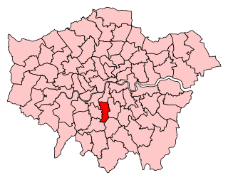
The region of Greater London, including the City of London, is divided into 73 parliamentary constituencies which are sub-classified as borough constituencies, affecting the type of electoral officer and level of expenses permitted.

The London Borough of Croydon has over 120 parks and open spaces within its boundaries, ranging from the 200 acre (80ha) Selsdon Wood Nature Reserve to many recreation grounds and sports fields scattered throughout the Borough. Croydon covers an area of 86.52 km², the 256th largest district in England. Croydon's physical features consist of many hills and rivers that are spread out across the borough and into the North Downs, Surrey and the rest of South London. Some of the open spaces in Croydon form part of the well-known London LOOP walks where the first section was opened on 3 May 1996 with a ceremony on Farthing Downs in Coulsdon. As a borough in Outer London it also contains some open countryside in the form of country parks. Croydon Council is associated with several other boroughs who are taking part in the Downlands Countryside Management Project. These boroughs are Sutton; and by Surrey County Council; the City of London Corporation; the Surrey districts of Reigate and Banstead and Tandridge; and the Countryside Agency. An additional partner is Natural Britain.
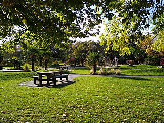
The London Borough of Lambeth, in spite of being close to the centre of London has over 64 areas of parks and open spaces, in addition to 34 play areas and eight paddling pools, within its boundaries. In common with all the London boroughs these green spaces provide "lungs" for the leisure pursuits of the inhabitants.
Croydon North West was a borough constituency represented in the House of Commons of the Parliament of the United Kingdom. It elected one Member of Parliament (MP) by the first past the post system of election.

The Norwood Ridge is a 10-square-mile (26 km2) rectangular upland which occupies the geographical centre of south London, centred 5 miles (8 km) south of London Bridge. Beneath its topsoil it is a ridge of London Clay that is capped on all sides with remaining natural gravel deposits mixed with some sandy soil, which in the South Thames basin is a material known as the Claygate Beds.

Grangewood Park is an extensive woodland area situated in South Norwood, London. It is managed by the London Borough of Croydon. It is bounded by Grange Road, Wharncliffe Road, and Ross Road. It covers an area of 27.7 acres. The park is located on the main A212 road between Thornton Heath and Upper Norwood/Crystal Palace. The nearest stations are Thornton Heath, Selhurst and Norwood Junction.

On 29 November 2012, a by-election was held for the UK House of Commons constituency of Croydon North in the London Borough of Croydon. The by-election was caused by the death of its Member of Parliament Malcolm Wicks. It took place on the same day as by-elections in Middlesbrough and Rotherham. The by-election was won by Steve Reed of the Labour Party.

Biggin Wood is an area of ancient oak woodland situated within the London Borough of Croydon. The London Wildlife Trust is currently working with Croydon Council and the Friends of Biggin Wood to improve the site for wildlife, as a part of The Great North Wood Project.
Streatham and Croydon North is a proposed constituency of the House of Commons in the UK Parliament. Further to the completion of the 2023 Periodic Review of Westminster constituencies, it will first be contested at the next general election.