
Upper Norwood is an area of south London, England, within the London Boroughs of Bromley, Croydon, Lambeth and Southwark. It is north of Croydon. The eastern part of it is better known as the Crystal Palace area. The SE19 London postcode covers the entirety of the district.

South Norwood Country Park is a park in South Norwood, close to Elmers End and Birkbeck train stations. The historic Kent-Surrey border runs through the site, and since 1965 it has been located wholly in the London Borough of Croydon. It is a 47 hectare green space which opened in 1989. The park is a mix of countryside and parkland, and land formerly used for sewage farms serving the growing London population.

South Norwood is a district of south-east London, England, within the London Borough of Croydon, Greater London and formerly in the historic county of Surrey. It is located 7.8 miles (12.5 km) south-east of Charing Cross, north of Woodside and Addiscombe, east of Selhurst and Thornton Heath, south of Crystal Palace/Upper Norwood and Anerley, and south-west of Penge.
The London Borough of Bexley owns and maintains over 100 parks and open spaces within its boundaries, with a total of 638 hectares. They include small gardens, river and woodland areas, and large parks with many sporting and other facilities.

The London Borough of Croydon has over 120 parks and open spaces within its boundaries, ranging from the 200 acre (80ha) Selsdon Wood Nature Reserve to many recreation grounds and sports fields scattered throughout the Borough. Croydon covers an area of 86.52 km2, the 256th largest district in England. Croydon's physical features consist of many hills and rivers that are spread out across the borough and into the North Downs, Surrey and the rest of South London. Some of the open spaces in Croydon form part of the well-known London LOOP walks where the first section was opened on 3 May 1996 with a ceremony on Farthing Downs in Coulsdon. As a borough in Outer London it also contains some open countryside in the form of country parks. Croydon Council is associated with several other boroughs who are taking part in the Downlands Countryside Management Project. These boroughs are Sutton; and by Surrey County Council; the City of London Corporation; the Surrey districts of Reigate and Banstead and Tandridge; and the Countryside Agency. An additional partner is Natural Britain.

Woodside is an area in south London, in the London Borough of Croydon. It is between Addiscombe and South Norwood. It is south of South Norwood, west of Shirley and Monks Orchard, north of Addiscombe, and east of Selhurst.
Norbury Brook is a tributary of the River Wandle that rises near Lower Addiscombe Road and flows north-west through Selhurst, Thornton Heath, and Norbury before joining the Wandle at south Wimbledon.
Penge Common was an area of north east Surrey and north west Kent which now forms part of London, England; covering most of Penge, all of Anerley, and parts of surrounding suburbs including South Norwood. It abutted the Great North Wood and John Rocque's 1745 map of London and its environs showed that Penge Common now included part of that wood.

The Norwood Ridge is a 10-square-mile (26 km2) rectangular upland which occupies the geographical centre of south London, centred 5 miles (8 km) south of London Bridge. Beneath its topsoil it is a ridge of London Clay that is capped on all sides with remaining natural gravel deposits mixed with some sandy soil, which in the South Thames basin is a material known as the Claygate Beds.
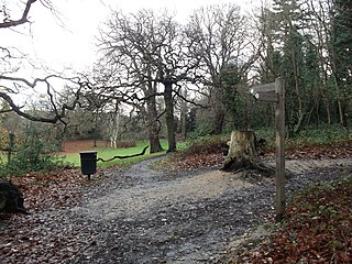
Beaulieu Heights 16 acres (6.5 ha) is an area of ancient woodland between South Norwood and Upper Norwood in the London Borough of Croydon, London. It is located between South Norwood Hill and Auckland Road with Auckland Rise to the north and Tummonds Gardens to the south. There are pedestrian entrances from South Norwood Hill and Auckland Rise, and a pond. The name is pronounced as if spelled "Beulah" like the nearby Beulah Hill, and not like the French word or the town of Beaulieu, Hampshire.

South Norwood Recreation Ground is a park located in South Norwood in the London Borough of Croydon. In 1889, Croydon Corporation acquired the land and the borough surveyor estimated that it would cost just over £1,300 to lay out. Over a quarter of the projected cost was to install land drainage, which indicates that the site was quite wet. The recreation ground includes a sports area, football pitches, tennis court, floodlit courts, bowling green with pavilion and a children's playground.

Brickfields Meadow is a meadow in Woodside in the London Borough of Croydon. It is located on the former site of a brickworks in Tennison Road and Dickensons Lane. The meadow covers an area of about 4.37 hectares. The meadow is not very well known to residents on Tennison Road, as the entrance is very secluded, beyond an EDF Energy transformer. The meadow includes: large pond where fishing is allowed, dipping platform, Buddleia Valley, grassland and woodland planting, small woodland area, and a children's play area which includes a mini maze and roundabout.

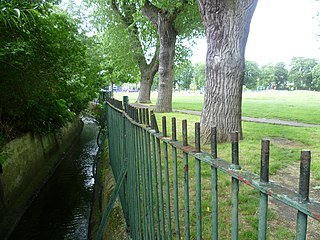
South Norwood Lake and Grounds is a park in South Norwood in the London Borough of Croydon. The main entrance is in Woodvale Avenue while other entrances are located in Auckland Road and Sylvan Road. The area measures up to 281⁄2 acres.
Selhurst is an area in the London Borough of Croydon, England, 7.8 miles (12.6 km) south-south-east of Charing Cross. Historically, it lays in Surrey County. The area is bounded to the west and south by Thornton Heath and Croydon and to the east and south by South Norwood and Woodside respectively. Selhurst Park, the home stadium of Crystal Palace Football Club, is sited at the northern end of the neighbourhood.

South Norwood Library is a purpose-built public library in South Norwood, South London. Also known locally as 'Brutalist Library' it stands in the London Borough of Croydon and is part of the Croydon Libraries arm of the council. The site on the corner of Selhurst Road and Lawrence Road first had a library built in 1897, which was replaced by the current building in 1966.

Apsley Road Playground is a park and playground situated in South Norwood, London, England. It is managed by the London Borough of Croydon and covers an area of 0.25 acres (0.10 ha). The park is mainly located on Apsley Road which is also the main entrance for the park. It is more targeted to the surrounding residential area. The playground's nearest Tramlink stop is Harrington Road.

Grangewood Park is an extensive woodland area situated in South Norwood, London. It is managed by the London Borough of Croydon. It is bounded by Grange Road, Wharncliffe Road, and Ross Road. It covers an area of 27.7 acres. The park is located on the main A212 road between Thornton Heath and Upper Norwood/Crystal Palace. The nearest stations are Thornton Heath, Selhurst and Norwood Junction.

Selhurst Road is a main road between South Norwood and Selhurst in the London Borough of Croydon, south London. It forms part of the A213 road which is a major A Road connecting both Sydenham and Croydon.

Wandle Park is an 8.5-hectare (21-acre) park located in the Broad Green Ward of Croydon, south London, England. It was opened in 1890 by the Mayor of Croydon. The site is protected by Fields in Trust through a legal "Deed of Dedication" safeguarding the future of the space as public recreation land for future generations to enjoy.


