
The London Borough of Croydon is a borough in south London, part of Outer London. It covers an area of 87 km2 (33.6 sq mi). It is the southernmost borough of London. At its centre is the town of Croydon from which the borough takes its name; while other urban centres include Coulsdon, Purley, South Norwood, Norbury, New Addington, Selsdon and Thornton Heath. Croydon is mentioned in Domesday Book, and from a small market town has expanded into one of the most populous areas on the fringe of London. The borough is now one of London's leading business, financial and cultural centres. Its influence in entertainment and the arts contribute to its status as a major metropolitan centre. Its population is 390,719, making it the most populous London borough and sixteenth largest English district.

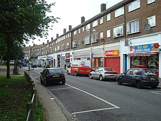
Purley is an area of the London Borough of Croydon in London, England, 11.7 miles (18.8 km) south of Charing Cross, with a history going back at least 800 years. It was originally granted as an estate from holdings at Sanderstead and until as a district of Surrey and then, with neighbouring Coulsdon, as an urban district that became an electoral ward of the London Borough of Croydon, becoming part of the ceremonial county of London, in 1965. In 2018 the Purley ward was divided into two: Purley and Woodcote, and Purley Oaks and Riddlesdown.

Waddon is a neighbourhood in the London Borough of Croydon, at the western end of the town of Croydon. The area borders the London Borough of Sutton.

The City of Maroondah is a local government area in Victoria, Australia in the eastern suburbs of Melbourne. Maroondah had a population of 115,043 in August 2021.

Croydon is a large town in South London, England, 9 miles (14 km) south of Charing Cross. Part of the London Borough of Croydon, a local government district of Greater London; it is one of the largest commercial districts in Greater London, with an extensive shopping area. The entire town had a population of 192,064 as of 2011, whilst the wider borough had a population of 384,837.
New Addington is an area of South London, England, within the London Borough of Croydon. It is located 5 miles south east of Croydon and is adjacent to the Greater London boundary with Surrey.

South Croydon in south London is the area surrounding the valley south of central Croydon and running as far south as the former Red Deer public house on the Brighton Road. It is bounded by Waddon to the West and Selsdon and Sanderstead to the East. It is part of the South Croydon (CR2) post town and in the London Borough of Croydon.
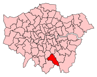
Croydon Central was a constituency created in 1974 and represented in the House of Commons of the UK Parliament from 2017 until its abolition for the 2024 general election by Labour MP Sarah Jones. The seat bucked the trend in national results in 2019, with Labour holding the seat with a slightly increased majority.

The region of Greater London, including the City of London, is divided into 75 parliamentary constituencies which are sub-classified as borough constituencies, affecting the type of electoral officer and level of expenses permitted. Since the general election of July 2024, 59 are represented by Labour MPs, 9 by Conservative MPs, 6 by Liberal Democrat MPs, and 1 by an independent MP.
The County Borough of Croydon was a local government district in and around the town of Croydon in north east Surrey, England from 1889 to 1965. Since 1965 the district has been part of the London Borough of Croydon within Greater London.

Woodside is an area in south London, in the London Borough of Croydon. It is between Addiscombe and South Norwood. It is south of South Norwood, west of Shirley and Monks Orchard, north of Addiscombe, and east of Selhurst.

Elections to Croydon Council in London, England were held on 4 May 2006. The whole council was up for election for the first time since the 2002 election. The Labour Party lost control of the council to the Conservative Party for the first time since 1994.

Pollards Hill is a small residential district straddling the south London boroughs of Croydon and Merton between Mitcham, Norbury and Thornton Heath. The boundary of the two boroughs is a street named Recreation Way. No roads directly cross the Croydon/Merton divide, and streets were planned according to each borough, leading to differing architectural or building schemes. Pollards Hill lends its name to a ward of the London Borough of Merton.

Broad Green is a ward in the London Borough of Croydon, London in the United Kingdom, covering the West Croydon area. Broad Green locality is divided between this ward and Selhurst ward.
On 29 November 2012, a by-election was held for the UK House of Commons constituency of Croydon North in the London Borough of Croydon. The by-election was caused by the death of its Member of Parliament Malcolm Wicks. It took place on the same day as by-elections in Middlesbrough and Rotherham. The by-election was won by Steve Reed of the Labour Party.

Wandle Park is an 8.5-hectare (21-acre) park located in the Broad Green Ward of Croydon, south London, England. It was opened in 1890 by the Mayor of Croydon. The site is protected by Fields in Trust through a legal "Deed of Dedication" safeguarding the future of the space as public recreation land for future generations to enjoy.

Addiscombe was a ward in the London Borough of Croydon, covering much of the Addiscombe and East Croydon areas of London in the United Kingdom. It extended from East Croydon railway station towards Woodside Green but did not actually cover the retail centre of Addiscombe, which was in the neighbouring Ashburton ward.

Waddon is a ward in the London Borough of Croydon. covering most of the Waddon area and parts of South Croydon, Haling Park and Old Town. The new ward gained territory from Broad Green, and lost some residences to South Croydon and Purley Oaks and Riddlesdown wards as a result of the review. The first election since the boundary changes was on 3 May 2018 as part of the 2018 local elections.. The Labour councillors held all 3 seats.

Ashburton was a ward in the London Borough of Croydon, in London in the United Kingdom. The ward covered the Ashburton area, as well as covering the main retail area of Addiscombe, the Stroud Green, Tollgate and Longheath Garden estates, and large parts of northern Shirley. The population of the ward at the 2011 Census was 14,721.

In the 2022 Croydon London Borough Council election, on 5 May 2022, all 70 members of Croydon London Borough Council, and the Mayor of Croydon, were up for election. The elections took place alongside the local elections in the other London boroughs and elections to local authorities across the United Kingdom. Jason Perry of the Conservative Party narrowly won the mayoral election.


