Addington Village Interchange

Last updated

51°21′23″N0°01′59″W / 51.356252°N 0.032966°W / 51.356252; -0.032966 Addington Village Interchange is a light rail stop and associated bus station serving Addington in the London Borough of Croydon in the southern suburbs of London. It opened on 10 May 2000 along with the line to New Addington. [3]

Contents

Addington Village is served by tram services operated by Tramlink. The tram stop is served by trams every 7-8 minutes between New Addington and West Croydon via East Croydon and Centrale. [4] [5]

A very small number of early morning and late evening services continue beyond Croydon to and from Therapia Lane and Wimbledon. During the evenings on weekends, the service is reduced to a tram every 15 minutes.

Services are operated using Bombardier CR4000 and Stadler Variobahn Trams.

Addington Village
Tramlink no-text roundel.svg Buses roundel (no text).svg
Addington Village tramstop western entrance.JPG
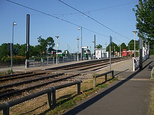
The tram stop and bus station (in background)
General information
Location Addington Village,
Croydon
United Kingdom
Operated by Tramlink
Platforms2
Construction
AccessibleYes
Other information
Fare zone London fare zones 3, 4, 5 and 6
History
Opened10 May 2000;23 years ago (2000-05-10)
Passengers
2009–100.532 million [1]
Preceding station Tramlink no-text roundel.svg Tramlink Following station
Gravel Hill
towards West Croydon
Tramlink
New Addington to Croydon town centre
Fieldway
towards New Addington

Bus Connections

The bus station is served by London Buses routes 64, 130, 314, 353, 359, 433, 466 and school routes 654 and 664. These provide connections to New Addington, Croydon Town Centre, Purley, Caterham, Thornton Heath, Hayes, Orpington, Bromley and Eltham. [6]

Free interchange for journeys made within an hour between bus services and between buses and trams is available at Addington Village as part of Transport for London's Hopper Fare. [7]

Related Research Articles

<span class="mw-page-title-main">Tramlink</span> Light rail tram system in South London

London Trams, previously Tramlink and Croydon Tramlink, is a light rail tram system serving Croydon and surrounding areas in South London, England. It began operation in 2000, the first tram system in the London region since 1952. It is managed by London Trams, a public body part of Transport for London (TfL), and has been operated by FirstGroup since 2017. Tramlink is one of two light rail networks in Greater London, the other being the Docklands Light Railway.

<span class="mw-page-title-main">Mitcham Junction station</span> Railway station and tram stop in Merton, London

Mitcham Junction is a National Rail station served by Southern and Thameslink trains, and a Tramlink stop. It is in the London Borough of Merton and is in Travelcard Zone 4.

<span class="mw-page-title-main">Birkbeck station</span> National Railway station and Tramlink tram stop in London, England

Birkbeck is a railway station and light rail stop in the London Borough of Bromley in the southern suburbs of London. On the rail network it is 10 miles 26 chains (16.6 km) measured from London Victoria. It is located on Elmers End Road (A214) and alongside Beckenham Crematorium.

<span class="mw-page-title-main">Arena tram stop (Croydon)</span> Tramlink tram stop in London, England

Arena tram stop is a light rail stop in the Woodside area of South Norwood in the London Borough of Croydon in the southern suburbs of London. The stop is located by the Croydon Sports Arena and serves the council estates of Longheath Gardens Estate and Tollgate Estate.

<span class="mw-page-title-main">Lebanon Road tram stop</span> Tramlink tram stop in London, England

Lebanon Road tram stop is a light rail stop in the London Borough of Croydon in the southern suburbs of London. It serves the residential area along Addiscombe Road to the east of the centre of the town of Croydon. The stop is named after Lebanon Road, a cross-street in the vicinity of the stop.

<span class="mw-page-title-main">Woodside tram stop</span> Tramlink tram stop in London, England

Woodside tram stop is a light rail stop situated between Woodside Green and Ashburton Park in the London Borough of Croydon in the southern suburbs of London. The stop is located on the site of the former Woodside railway station of the Woodside and South Croydon Railway; the old station buildings survive, though not used by Tramlink.

<span class="mw-page-title-main">Blackhorse Lane tram stop</span> Tramlink tram stop in London, England

Blackhorse Lane tram stop is a light rail stop in the London Borough of Croydon in the southern suburbs of London.

<span class="mw-page-title-main">Addiscombe tram stop</span> Tram stop in London, England

Addiscombe tram stop is a light rail stop in the London Borough of Croydon in the southern suburbs of London.

<span class="mw-page-title-main">Morden Road tram stop</span> Tramlink tram stop in London, England

Morden Road is a Tramlink stop in the London Borough of Merton. It is on the site of the former Morden Road railway station on the Wimbledon-West Croydon line, which closed to rail traffic in 1997. The tram stop consists of two platforms on either side of the double track, linked by pedestrian level crossings. Immediately to the east of the station is a single-track section which reaches as far as Phipps Bridge tram stop.

<span class="mw-page-title-main">Ampere Way tram stop</span> Tramlink tram stop in London, England

Ampere Way is a tram stop in the London Borough of Croydon, serving the Purley Way commercial area. Tramlink trams serve the stop, which is located opposite IKEA Croydon.

<span class="mw-page-title-main">Waddon Marsh tram stop</span> Tramlink tram stop in London, England

Waddon Marsh tram stop is a stop on the Tramlink service serving the area between Waddon and Croydon in the London Borough of Croydon. It is close to the commercial areas of the Purley Way. The stop is overshadowed by the giant gasometer of Croydon Gas Works. There was previously a railway station about 100 metres north of this site called Waddon Marsh, though all that remains of the previous station is an access path still lined with streetlamps painted NSE red.

<span class="mw-page-title-main">Fieldway tram stop</span> Tramstop in New Addington, London Borough of Croydon, UK

Fieldway tram stop is a light rail stop serving the Fieldway residential area of New Addington, in the London Borough of Croydon in the southern suburbs of London. It is adjacent to a northbound bus stop on the A2022 Lodge Lane.

<span class="mw-page-title-main">Centrale tram stop</span> Tramlink tram stop in London, England

Centrale tram stop is a stop on the Tramlink service in Croydon town centre, serving the Centrale shopping centre. The tram stop was provided and paid for as part of the development of the shopping centre.

<span class="mw-page-title-main">New Addington tram stop</span> Tramlink tram stop in London, England

New Addington is a terminal tram stop serving the centre of New Addington, in the London Borough of Croydon, in the southern suburbs of London. The tram stop is served by London Trams, which connects New Addington with central Croydon. The next stop on the line towards central Croydon is King Henry's Drive.

<span class="mw-page-title-main">Coombe Lane tram stop</span> Tramlink tram stop in London, England

Coombe Lane tram stop is a light rail stop in the London Borough of Croydon in the southern suburbs of London. It is located south of Addington Hills and serves Royal Russell School and the Ballards residential estate.

<span class="mw-page-title-main">Lloyd Park tram stop</span> Tramlink tram stop in London, England

Lloyd Park tram stop is on the edge of Lloyd Park in the London Borough of Croydon in the southern suburbs of London, beside Coombe Road and opposite Croham Park Avenue and Castlemaine Avenue. It is 200 metres east of the site of the Coombe Road railway station, on the former Woodside and South Croydon Railway.

<span class="mw-page-title-main">Sandilands tram stop</span> Tramlink tram stop in London, England

Sandilands tram stop is a light rail stop in the London Borough of Croydon in the southern suburbs of London. It serves the residential area along Addiscombe Road to the east of the centre of the town of Croydon.

<span class="mw-page-title-main">Beckenham Road tram stop</span> Tramlink tram stop in London, England

Beckenham Road tram stop is a light rail stop in the London Borough of Bromley in the southern suburbs of London. The stop is located on an embankment above Beckenham Road (A234) which connects Beckenham with Crystal Palace and Penge on the site of the short-lived (1858–1860) West End of London & Crystal Palace Railway Penge station.

<span class="mw-page-title-main">Gravel Hill tram stop</span> Tramlink tram stop in London, England

Gravel Hill tram stop is a light rail stop serving Addington, in the London Borough of Croydon in the southern suburbs of London. It is the main destination for tourists visiting the historic site of Addington Palace. It is also used by students who attend John Ruskin College and is the nearest stop for Forestdale.

<span class="mw-page-title-main">King Henry's Drive tram stop</span> Tramlink tram stop in London, England

King Henry's Drive tram stop is a light rail stop serving the Betchworth Way residential area of New Addington, in the London Borough of Croydon in the southern suburbs of London. It is located in the wide central reservation of a dual carriageway.

References

  1. "Tram Stop Usage 2009-10 (FOI)" (XLS). Tramlink annual passenger performance 2009-2010. Transport for London. 18 August 2011. Retrieved 28 November 2012.
  2. "Tramlink numbers 2010-2011" (PDF). Tramlink annual passenger performance 2010-2011. Transport for London. 28 March 2012. Retrieved 28 November 2012.
  3. Croydon Tramlink opened for business The Railway Magazine issue 1191 July 2000 page 10
  4. "Tram Timetables". Transport for London . Retrieved 4 January 2023.
  5. "London Trams Map" (PDF). Transport for London . Retrieved 4 January 2022.
  6. "Buses and trams from Addington Village" (PDF). Transport for London. Retrieved 13 March 2011.
  7. "Bus and Tram Fares". Transport for London . Retrieved 4 January 2022.