This is a list of parks and open spaces within the boundary of the London Borough of Croydon, England.
This is a list of parks and open spaces within the boundary of the London Borough of Croydon, England.
| Name | Place | Area | Image |
|---|---|---|---|
| Addington Hills | Shirley | 130 acres (53 ha) |  |
| Addington Park | Addington | 24.5 acres (9.9 ha) |  |
| Addington Vale | New Addington | 48 acres (19 ha) | |
| Addiscombe Railway Park | Addiscombe | 4 acres (1.6 ha) |  |
| Addiscombe Recreation Ground | Addiscombe | 8 acres (3.2 ha) |  |
| Apsley Road Playground | South Norwood | 0.25 acres (0.10 ha) |  |
| Ashburton Park | Woodside | 18.5 acres (7.5 ha) |  |
| Ashburton Playing Fields | Woodside | 49.5 acres (20.0 ha) |  |
| Name | Place | Area | Image |
|---|---|---|---|
| Beaulieu Heights | South Norwood | 16 acres (6.5 ha) |  |
| Betts Mead Recreation Ground | Kenley | 30 acres (12 ha) | |
| Beulah Hill Pond | Upper Norwood | 1.5 acres (0.61 ha) |  |
| Biggin Wood | Upper Norwood | 13.5 acres (5.5 ha) |  |
| Birchwood and Castle Hill Ruffetts | New Addington | 37.25 acres (15.07 ha) | |
| Boulogne Road Playground | Thornton Heath | 1.5 acres (0.61 ha) | |
| Boundary Woods | New Addington | 4.25 acres (1.72 ha) | |
| Bourne Park | Kenley | 8.5 acres (3.4 ha) | |
| Bradmore Green | Old Coulsdon | 4 acres (1.6 ha) |  |
| Bramley Bank | Shirley | 24 acres (9.7 ha) |  |
| Brickfields Meadow | South Norwood | 4.37 ha (10.8 acres) |  |
| Name | Place | Area | Image |
|---|---|---|---|
| Canterbury Road Recreation Ground | Broad Green | 4.5 acres (1.8 ha) |  |
| Central Nursery | Shirley | 10.5 acres (4.2 ha) | |
| Chaldon Way Gardens | Coulsdon | 0.49 acres (0.20 ha) |  |
| Coombe Wood | Shirley | 5.67 ha (14.0 acres) |  |
| Copse Hill Spinney | Purley | 1 acre (0.40 ha) | |
| Cotelands | Croydon | 0.49 acres (0.20 ha) |  |
| Coulsdon Memorial Ground | Coulsdon | 10 acres (4.0 ha) |  |
| Courtwood Children's Playground | Forestdale | 0.74 acres (0.30 ha) | |
| Croham Hurst | South Croydon | 34.3 ha (85 acres) [1] |  |
| Name | Place | Area | Image |
|---|---|---|---|
| Dartnell Road Wayside Amentity Area | Woodside | 0.15 acres (0.061 ha) | |
| Duppas Hill | Croydon | 34 acres (14 ha) |  |
| Name | Place | Area | Image |
|---|---|---|---|
| Fairfield Gardens | Croydon | 2 acres (0.81 ha) |  |
| Falconwood Meadow | Forestdale | 3.5 acres (1.4 ha) | |
| Farthing Downs | Coulsdon | 235 acres (95 ha) |  |
| Foxearth Spinney | Selsdon | 0.25 acres (0.10 ha) | |
| Foxes Wood | Shirley | 8.105 acres (3.280 ha) |  |
| Foxley Wood | Purley | 26.5 acres (10.7 ha) |  |
| Fox Shaw | Selsdon | 9.75 acres (3.95 ha) |
| Name | Place | Area | Image |
|---|---|---|---|
| Glade Wood | Monks Orchard | 3 acres (1.2 ha) | |
| Grange Park | Old Coulsdon | 11 acres (4.5 ha) | |
| Grangewood Park | South Norwood | 27.75 acres (11.23 ha) |  |
| Green Lane Sports Ground | Norbury | 10 acres (4.0 ha) |
| Name | Place | Area | Image |
|---|---|---|---|
| Haling Grove | South Croydon | 10 acres (4.0 ha) |  |
| Hamsey Green Pond | Sanderstead | 0.08 ha (0.20 acres) | |
| Happy Valley Park | Old Coulsdon | 252.5 acres (102.2 ha) | 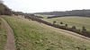 |
| Hawkhirst | Kenley | 35.5 acres (14.4 ha) |  |
| Heathfield | Addington | 18 acres (7.3 ha) |  |
| Heavers Meadow | Selhurst | 8.75 acres (3.54 ha) |  |
| Higher Drive Recreation Ground | Purley | 12.5 acres (5.1 ha) | |
| Hutchinson's Bank | New Addington | 54 acres (22 ha) |  |
| Name | Place | Area | Image |
|---|---|---|---|
| Inwood | Old Coulsdon | 5 acres (2.0 ha) |
| Name | Place | Area | Image |
|---|---|---|---|
| Jewel's Wood | New Addington | 38.5 acres (15.6 ha) |
| Name | Place | Area | Image |
|---|---|---|---|
| Kenley Common | Kenley | 138 acres (56 ha) |  |
| King George's Field | Selhurst | 3 acres (1.2 ha) | |
| Kings Wood | Sanderstead | 147.5 acres (59.7 ha) |  |
| Name | Place | Area | Image |
|---|---|---|---|
| Ladygrove | Forestdale | 0.25 acres (0.10 ha) | |
| Little Road Playground | Addiscombe | 0.25 acres (0.10 ha) | |
| Littleheath Woods | Selsdon | 64 acres (26 ha) |  |
| Lloyd Park | Croydon | 114 acres (46 ha) |  |
| Long Lane Wood | Monks Orchard | 15 acres (6.1 ha) |  |
| Name | Place | Area | Image |
|---|---|---|---|
| Mayfield Road Playground | Thornton Heath | 1.5 acres (0.61 ha) | |
| Millers Pond | Shirley | 4 acres (1.6 ha) |  |
| Millstock | Hooley | 60 acres (24 ha) | |
| Milne Park | New Addington | 17 acres (6.9 ha) |  |
| Mitcham Common | Mitcham | 460 acres (190 ha) |  |
| Name | Place | Area | Image |
|---|---|---|---|
| Norbury Hall Park | Norbury | 8 acres (3.2 ha) |  |
| Norbury Park | Norbury | 28.5 acres (11.5 ha) |  |
| Northborough Road Playground | Norbury | 3 acres (1.2 ha) |  |
| Northbrook Road Playground | Thornton Heath | 0.75 acres (0.30 ha) | |
| North Down Recreation Ground | New Addington | 28.5 acres (11.5 ha) |  |
| Northwood Road Playground | Norbury | 0.25 acres (0.10 ha) | |
| Norwood Grove | Upper Norwood | 13.62 ha (33.7 acres) [2] |  |
| Name | Place | Area | Image |
|---|---|---|---|
| Oakland Wood | South Norwood | 0.16 ha (0.40 acres) |
| Name | Place | Area | Image |
|---|---|---|---|
| Park Hill Recreation Ground | Croydon | 15 acres (6.1 ha) |  |
| Parkfields | Monks Orchard | 13.25 acres (5.36 ha) | |
| Pinewood | Shirley | 11 acres (4.5 ha) | |
| Pollards Hill Park | Pollards Hill | 7.75 acres (3.14 ha) |  |
| Promenade De Verdun | Woodcote | 1 acre (0.40 ha) |  |
| Purley Beeches | Sanderstead | 17.75 acres (7.18 ha) |  |
| Purley Way Playing Fields | Waddon | 109 acres (44 ha) |  |
| Purley Way West | Waddon | 20.75 acres (8.40 ha) |  |
| Name | Place | Area | Image |
|---|---|---|---|
| Queen's Gardens | Croydon | 2.25 acres (0.91 ha) |  |
| Queenhill Road Playspace | Selsdon | 2.25 acres (0.91 ha) |
| Name | Place | Area | Image |
|---|---|---|---|
| Ragged Grove | Sanderstead | 3 acres (1.2 ha) | |
| Rickman Hill | Coulsdon | 16.5 acres (6.7 ha) |  |
| Riddlesdown Common | Kenley | 37 acres (15 ha) |  |
| Rotary Field | Purley | 4.5 acres (1.8 ha) |  |
| Rowdown Field | New Addington | 29.2 acres (11.8 ha) | |
| Rowdown Wood | New Addington | 34 acres (14 ha) |  |
| Name | Place | Area | Image |
|---|---|---|---|
| Sanderstead Plantation | Sanderstead | 21.75 acres (8.80 ha) | |
| Sanderstead Pond | Sanderstead | 3.5 acres (1.4 ha) |  |
| Sanderstead Recreation Ground | Sanderstead | 19.5 acres (7.9 ha) | |
| Selsdon Recreation Ground | Selsdon | 10 acres (4.0 ha) | |
| Selsdon Wood | Selsdon | 200 acres (81 ha) |  |
| Shirley Church Recreation Ground | Shirley | 8.5 acres (3.4 ha) |  |
| Shirley Heath | Shirley | 68 acres (28 ha) |  |
| Shirley Park Estate | Shirley | 11 acres (4.5 ha) | |
| South Croydon Recreation Ground | South Croydon | 8.5 acres (3.4 ha) |  |
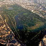
| South Norwood Country Park | South Norwood | 125 acres (51 ha) |  |
| South Norwood Lake and Grounds | South Norwood | 28.5 acres (11.5 ha) |  |
| South Norwood Recreation Ground | South Norwood | 14 acres (5.7 ha) | 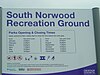 |
| Spring Park Wood | Shirley | 7 acres (2.8 ha) |  |
| St. James' Church Rest Garden | Croydon | 2 acres (0.81 ha) |  |
| St. Johns Memorial Garden | Old Town | 2 acres (0.81 ha) |  |
| Stambourne Woodland Walk | Upper Norwood | 4.75 acres (1.92 ha) |  |
| Stroud Green Well | Shirley | 2.78 ha (6.9 acres) |
| Name | Place | Area | Image |
|---|---|---|---|
| Temple Avenue Copse | Shirley | 1 acre (0.40 ha) | |
| The Avenue | Kenley | 4.75 acres (1.92 ha) | |
| The Beeches | Sanderstead | 2.75 acres (1.11 ha) | |
| The Lawns | Upper Norwood | 15.5 acres (6.3 ha) |  |
| The Ruffet | South Croydon | 2.5 acres (1.0 ha) | |
| Thornton Heath Recreation Ground | Thornton Heath | 13.5 acres (5.5 ha) |  |
| Three Corner Grove | New Addington | 4 acres (1.6 ha) | |
| Threehalfpenny Wood | Addington | 25 acres (10 ha) |  |
| Trumble Gardens | Thornton Heath | 3 acres (1.2 ha) |
| Name | Place | Area | Image |
|---|---|---|---|
| Upper Norwood Recreation Ground | Upper Norwood | 19 acres (7.7 ha) |  |
| Name | Place | Area | Image |
|---|---|---|---|
| Waddon Ponds | Waddon | 8.5 acres (3.4 ha) |  |
| Wandle Park | Waddon | 21 acres (8.5 ha) |  |
| Westow Park | Upper Norwood | 6.75 acres (2.73 ha) |  |
| Wettern Tree Garden | Sanderstead | 2.75 acres (1.11 ha) |  |
| Whitehorse Meadow | South Norwood | 1.09 ha (2.7 acres) |  |
| Whitehorse Road Recreation Ground | Croydon | 4.5 acres (1.8 ha) |  |
| Wilford Road Recreation Ground | Croydon | 2.75 acres (1.11 ha) |  |
| Woodcote Grove Recreation Ground | Coulsdon | 10 acres (4.0 ha) | |
| Woodcote Village Green | Purley | 3.5 acres (1.4 ha) |  |
| Woodside Green | Woodside | 4.75 acres (1.92 ha) |  |

Coulsdon, is a town in south London, England, within the London Borough of Croydon. Coulsdon was an ancient parish in the county of Surrey that included the settlements of Purley and Kenley. It was merged with Sanderstead in 1915 to form the Coulsdon and Purley Urban District and has formed part of Greater London since 1965.

South Norwood Country Park is a park in South Norwood, close to Elmers End and Birkbeck train stations. The historic Kent-Surrey border runs through the site, and since 1965 it has been located wholly in the London Borough of Croydon. It is a 47 hectare green space which opened in 1989. The park is a mix of countryside and parkland, and land formerly used for sewage farms serving the growing London population.

South Croydon in south London is the area surrounding the valley south of central Croydon and running as far south as the former Red Deer public house on the Brighton Road. It is bounded by Waddon to the West and Selsdon and Sanderstead to the East. It is part of the South Croydon (CR2) post town and in the London Borough of Croydon.
The London Borough of Bexley owns and maintains over 100 parks and open spaces within its boundaries, with a total of 638 hectares. They include small gardens, river and woodland areas, and large parks with many sporting and other facilities.

Woodside is an area in south London, in the London Borough of Croydon. It is between Addiscombe and South Norwood. It is south of South Norwood, west of Shirley and Monks Orchard, north of Addiscombe, and east of Selhurst.
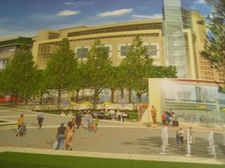
Park Place was a proposed shopping centre which had been expected to open in Croydon, London by 2011. The date was continuously pushed back due to a number of problems between different developers, financial backers and the local council. It was cancelled in 2009, as other schemes began progress, such as the extension to Centrale and the possible takeover of the Whitgift Centre by Westfield Group. Park Place was part of the Croydon Vision 2020 re-generation scheme.

There are many parks and open spaces in Greater London, England.

South Norwood Recreation Ground is a park located in South Norwood in the London Borough of Croydon. In 1889, Croydon Corporation acquired the land and the borough surveyor estimated that it would cost just over £1,300 to lay out. Over a quarter of the projected cost was to install land drainage, which indicates that the site was quite wet. The recreation ground includes a sports area, football pitches, tennis court, floodlit courts, bowling green with pavilion and a children's playground.

South Norwood Lake and Grounds is a park in South Norwood in the London Borough of Croydon. The main entrance is in Woodvale Avenue while other entrances are located in Auckland Road and Sylvan Road. The area measures up to 281⁄2 acres.

Addington Park is a park situated in Addington in the London Borough of Croydon. The park covers an area of 24.5 acres (9.9 ha).
Addington Vale is a 48 acres (19 ha) park situated in New Addington in the London Borough of Croydon. The park extends from King Henrys Drive in the north to Arnhem Drive in the south. It is bordered by Queen Elizabeths Drive to the west and Godric Crescent and Hares Bank to the east. The nearest Tramlink station is New Addington.

Addiscombe Recreation Ground, commonly known as Bingham Park, is a park situated in Addiscombe, London. The park is managed by London Borough of Croydon. Addiscombe tram stop is located just next to the recreation ground and is served by Tramlink. The area covers 8 acres (3.2 ha).

Apsley Road Playground is a park and playground situated in South Norwood, London, England. It is managed by the London Borough of Croydon and covers an area of 0.25 acres (0.10 ha). The park is mainly located on Apsley Road which is also the main entrance for the park. It is more targeted to the surrounding residential area. The playground's nearest Tramlink stop is Harrington Road.

Ashburton Playing Fields is a playing field located in Woodside, London. It is managed by the London Borough of Croydon. The fields are bordered by Bywood Avenue in the north, Chaucer Green in the west and Woodville Avenue in the east. Stroud Green Way backs onto the western boundary. Tramlink services for the park are Arena and Woodside. It covers an area of 49.5 acres (20 ha).

Park Hill Recreation Ground is a 15 acres (6.1 ha) park near the centre of Croydon, Greater London, managed by the London Borough of Croydon. It runs from Barclay Road to Coombe Road beside the railway line, with the main entrances on Water Tower Hill and Barclay Road. The nearest stations are East Croydon to the north for Tramlink and National Rail services and South Croydon to the south for National Rail. The park was officially renamed as Park Hill in 1964.

Grangewood Park is an extensive woodland area situated in South Norwood, London. It is managed by the London Borough of Croydon. It is bounded by Grange Road, Wharncliffe Road, and Ross Road. It covers an area of 27.7 acres. The park is located on the main A212 road between Thornton Heath and Upper Norwood/Crystal Palace. The nearest stations are Thornton Heath, Selhurst and Norwood Junction.

Selsdon Wood is a woodland area located in the London Borough of Croydon. The park is owned by the National Trust but managed by the London Borough of Croydon. It is a Local Nature Reserve. The wood has a Friends group - the Friends of Selsdon Wood (FSW) - who have their own website.

Wandle Park is an 8.5-hectare (21-acre) park located in the Broad Green Ward of Croydon, south London, England. It was opened in 1890 by the Mayor of Croydon. The site is protected by Fields in Trust through a legal "Deed of Dedication" safeguarding the future of the space as public recreation land for future generations to enjoy.

Lloyd Park is a 114 acres (46 ha) park on the outskirts of central Croydon, Greater London, managed by the London Borough of Croydon. It is bordered by Coombe Road to the south and Lloyd Park Avenue to the west. To the north, access is from Deepdene and Mapledale Avenue, and the park adjoins Grimwade Avenue and Addiscombe Cricket Club. To the east the park is bordered by Shirley Park Golf Course. It was created from land owned by Frank Lloyd a newspaper proprietor who died in 1927 which was bequeathed to the Borough of Croydon by his family, after his death.
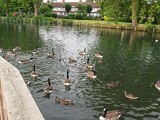
Waddon Ponds is an ornamental 8.5 acres (3.4 ha) urban park / inland water in the western part of the London Borough of Croydon, by whom it is managed. It is bordered to the north by Mill Lane, and on the other three sides by Waddon Court Road, Court Drive and The Ridgeway.