Coulsdon, is a town in south London, England, within the London Borough of Croydon. Coulsdon was an ancient parish in the county of Surrey that included the settlements of Purley and Kenley. It was merged with Sanderstead in 1915 to form the Coulsdon and Purley Urban District and has formed part of Greater London since 1965.

Kenley is a residential suburb within the London Borough of Croydon. It is located 13 miles (21 km) south of Charing Cross and within the southern boundary of London, England. Surrounded by the Metropolitan Green Belt on three sides, it includes the large open spaces of Kenley Common and Kenley Aerodrome. Kenley was part of the ancient parish of Coulsdon in the county of Surrey and was connected to central London by rail in 1856. As the population of the area was growing, it became part of Coulsdon and Purley Urban District in 1915 and has formed part of Greater London since 1965. At the 2011 Census, Kenley had a population of 14,966.

South Croydon in south London is the area surrounding the valley south of central Croydon and running as far south as the former Red Deer public house on the Brighton Road. It is bounded by Waddon to the West and Selsdon and Sanderstead to the East. It is part of the South Croydon (CR2) post town and in the London Borough of Croydon.

Ashleworth Ham is a 104.73-hectare (258.8-acre) biological Site of Special Scientific Interest. It is a large area of grassland on the Severn floodplain, north of Ashleworth in Gloucestershire, England. It is registered as a Site of Special Scientific Interest and was notified in 1974 and renotified in 1985. Ashleworth Ham received this designation because it is one of three sites in the Severn Vale where migratory waterfowl winter.
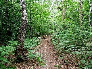
Croham Hurst is a 33.6 hectare biological Site of Special Scientific Interest (SSSI) and a Site of Metropolitan Importance for Nature Conservation in South Croydon in the London Borough of Croydon. Its SSSI designation is due to its importance for nature conservation, but it is also a Regionally Important Geological Site.

Ingrebourne Marshes are a 74.8 hectare biological Site of Special Scientific Interest in Hornchurch in the London Borough of Havering. Ingrebourne Valley Local Nature Reserve includes a small part of the SSSI west of the River Ingrebourne. The site is managed by the Essex Wildlife Trust

Totternhoe Knolls is a 13.1-hectare (32-acre) Site of Special Scientific Interest (SSSI) in Totternhoe in Bedfordshire. It is also a local nature reserve, and part of the Chilterns Area of Outstanding Natural Beauty. The site is owned by Central Bedfordshire Council and leased to the National Trust. Most of the site is maintained jointly by the National Trust and the Wildlife Trust for Bedfordshire, Cambridgeshire and Northamptonshire (WTBCN), and is part of the WTBCN Totternhoe nature reserve, which also includes Totternhoe Chalk Quarry and Totternhoe Stone Pit. The SSSI also includes Totternhoe Castle, the earthworks of a Norman motte-and-bailey castle which is a Scheduled monument.

Sandhurst to Owlsmoor Bogs and Heaths is an 85.8-hectare (212-acre) biological Site of Special Scientific Interest (SSSI) on the northern outskirts of Sandhurst in Berkshire. Part of the SSSI is Wildmoor Heath nature reserve, which is managed by the Berkshire, Buckinghamshire and Oxfordshire Wildlife Trust. and the SSSI is part of Thames Basin Heaths Special Protection Area.

Greenham and Crookham Commons are two adjoining public park areas of 280.5-hectare (693-acre) common land designated as a biological Site of Special Scientific Interest (SSSI) in the civil parishes of Greenham and Thatcham, on the southern outskirts of Newbury in the English county of Berkshire.

Farthing Downs is an open space in Coulsdon in the London Borough of Croydon. Together with Eight Acres Common and New Hill to the south-east, it is owned and managed by the Corporation of London. Farthing Downs and Eight Acres Common are part of the Farthing Downs and Happy Valley Site of Special Scientific Interest. Happy Valley Park is a green space to the south owned by Croydon Council. Farthing Downs is also a scheduled monument.

Old Park Wood is a 16.7-hectare (41-acre) Site of Special Scientific Interest in Harefield in the London Borough of Hillingdon. The south-east part is an 8-hectare (20-acre) nature reserve owned and managed by the Hertfordshire and Middlesex Wildlife Trust.

Frays Farm Meadows is a 28.2-hectare (70-acre) biological Site of Special Scientific Interest near Denham in the London Borough of Hillingdon. It was notified as an SSSI in 1981, and has been managed by the London Wildlife Trust on behalf of Hillingdon Council since 1999. It is part of the Colne Valley Regional Park.

Mid Colne Valley is a 132 hectare biological Site of Special Scientific Interest in Harefield in the London Borough of Hillingdon and Denham in South Buckinghamshire. Its main importance lies in its extensive diversity of birdlife in lakes in former gravel pits.

Happy Valley Park is a public park in Coulsdon in the London Borough of Croydon. It is owned and managed by Croydon Council. Located in the Green Belt, most of it forms part of the Farthing Downs and Happy Valley Site of Special Scientific Interest.

Harrow Weald Common is an 18-hectare area of woodland, heath and pasture in Harrow Weald in the London Borough of Harrow. It is considered of considerable importance for wildlife, and it was formerly part of the Stanmore and Harrow Weald Commons and Bentley Priory Site of Special Scientific Interest, but in 1987 the boundaries of the SSSI were revised to exclude the Common. It has been designated by the Mayor of London as a Site of Metropolitan Importance for Nature Conservation.

Wansunt Pit is a 1.9-hectare (4.7-acre) geological Site of Special Scientific Interest in Dartford Heath between Crayford in the London Borough of Bexley and Dartford in Kent. It is also a Geological Conservation Review site. It is important geologically because it exposes the Dartford Heath Gravel, and the relationship of this exposure to the Swanscombe sequence and the Thames Terraces is a controversial issue in Thames Pleistocene studies. The site is part of Braeburn Park, a nature reserve managed by the London Wildlife Trust.

Alpine Meadow is a 0.4 hectare nature reserve near Berkhamsted in Hertfordshire in the United Kingdom. It is a designated biological Site of Special Scientific Interest (SSSI), managed by the Hertfordshire and Middlesex Wildlife Trust and the planning authority is Dacorum Borough Council.