
The London Borough of Hillingdon is a London borough in Greater London, England. It forms part of outer London and West London, being the westernmost London borough. It was formed in 1965 from the districts of Hayes and Harlington, Ruislip-Northwood, Uxbridge, and Yiewsley and West Drayton. The borough includes most of Heathrow Airport and Brunel University, and is the second largest of the 32 London boroughs by area.

Uxbridge Vine Street station opened on 8 September 1856 as Uxbridge Station and was the earliest of three railway stations in Uxbridge, London.

The Colne is a river and a tributary of the River Thames in England. Just over half its course is in south Hertfordshire. Downstream, it forms the boundary between Buckinghamshire and the London Borough of Hillingdon. The confluence with the River Thames is on the Staines reach at Staines-upon-Thames.

Uxbridge Cricket Club is a cricket club based in Uxbridge, London, England. Uxbridge CC is a member of the Middlesex County Cricket League which is a designated ECB Premier League.
The Colne Brook is a river in England that is a distributary of the River Colne which runs from Uxbridge Moor, there forming the western border of Greater London, to the River Thames just below Bell Weir Lock in Hythe End, Wraysbury, Berkshire.

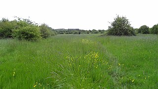
Frays River is a semi-canalised short river in England that branches off the River Colne at Uxbridge Moor and rejoins it at West Drayton. It is believed to be a mainly man-made anabranch north of the confluence with the River Pinn to feed watermills in the Parish of Hillingdon. The river is believed to be named after John Fray who owned Cowley Hall in the fifteenth century. Other names for the river are the Uxbridge and Cowley Mill Stream, the Cowley Stream or the Colham Mill Stream. Two of the three mills in Hillingdon Parish recorded in the Domesday book are believed to have been located on the southern section of the river.
The New Ground, Uxbridge Moor near Uxbridge, Middlesex was used as a venue for cricket matches between 1740 and 1790. It was an occasional home ground for Middlesex county cricket teams and by the local Uxbridge club and was used for two first-class cricket matches, one in 1789 and the other in 1790.

Brent Park is a small public park of 2.24 hectares in Hendon in the London Borough of Barnet. It is part of the 'Lower Dollis Brook' Site of Borough Importance for Nature Conservation, Grade II.

Bentley Priory Nature Reserve is a Site of Special Scientific Interest and Local Nature Reserve in Stanmore in the London Borough of Harrow, surrounding the stately home of Bentley Priory. It is a 55 hectare mosaic of ancient woodland, unimproved neutral grassland, scrub, wetland, streams and an artificial lake, an unusual combination of habitats in Greater London.

The Norman Leddy Memorial Gardens in Hayes, in London, United Kingdom, is one of Hillingdon Borough's designated gardens of excellence. In September 2010, the Gardens earned a gold award for Best London Small Park in the London in Bloom competition.

Rose Walk is a 2.7 hectare Local Nature Reserve in Berrylands in the Royal Borough of Kingston upon Thames in London. It is also part of the Hogsmill Valley Site of Borough Importance for Nature Conservation, Grade 1.

Northolt Manor is a 1.8 hectare scheduled monument, local nature reserve and Site of Borough Importance for Nature Conservation, Grade II, in Northolt in the London Borough of Ealing. It is owned and managed by Ealing Council.
Islip Manor Meadows is a 23.75 hectare Local Nature Reserve and Site of Metropolitan Importance for Nature Conservation in Northolt in the London Borough of Ealing. It is owned and managed by Ealing Council.

Croxley Common Moor is a 39.5-hectare (98-acre) biological Site of Special Scientific Interest (SSSI) and Local Nature Reserve in Croxley Green, Hertfordshire. It is owned by Three Rivers District Council and managed by the council together with the Countryside Management Service and the Friends of Croxley Common Moor. Most of it is a registered common.

Sarratt Bottom nature Reserve in Hertfordshire is a 3.2-hectare (7.9-acre) biological Site of Special Scientific Interest. The site is a meadow beside the River Chess. It is an example of damp grassland which has been traditionally managed for grazing. There are also areas of swamp and marsh. The main plants in grassland areas include sweet vernal grass and meadow foxtail, and marsh horsetail and common spike-rush are common in damper areas. The site has hedgehogs and a wide variety of wetland birds and invertebrates.

Uxbridge Alderglade is a 2.9-hectare (7.2-acre) nature reserve in Uxbridge in the London Borough of Hillingdon. It is managed by the Herts and Middlesex Wildlife Trust.

Park Road Pond is a pond in Uxbridge in the London Borough of Hillingdon. It is managed as a nature reserve by the London Wildlife Trust (LWT), and is a Site of Borough Importance for Nature Conservation, Grade I.

Uxbridge College Pond is a small pond in the grounds of Uxbridge College in Uxbridge in the London Borough of Hillingdon. It is a Site of Borough Importance for Nature Conservation, Grade I.

Alder Moors is a 8.5-hectare (21-acre) Local Nature Reserve in Woodley, a suburb of Reading in Berkshire. It is owned and managed by Wokingham District Council.

The Flashes is a 115.1-hectare (284-acre) Local Nature Reserve west of Godalming in Surrey. It is owned by the National Trust and managed by Waverley Borough Council. It is part of Thursley, Hankley and Frensham Commons Sites of Special Scientific Interest, Thursley, Ash, Pirbright & Chobham Special Area of Conservation and Thursley, Hankley & Frensham Commons Special Protection Area,
