The Swale is a tidal channel of the Thames estuary that separates the Isle of Sheppey from the rest of Kent. On its banks is a 6,509.4-hectare (16,085-acre) biological Site of Special Scientific Interest which stretches from Sittingbourne to Whitstable in Kent. It is also a Ramsar internationally important wetland site and a Special Protection Area under the European Union Directive on the Conservation of Wild Birds. Parts of it are a Nature Conservation Review site, Grade I, National Nature Reserves, a Kent Wildlife Trust nature reserve and a Local Nature Reserve.
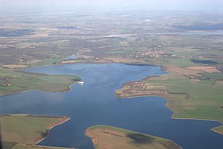
Abberton Reservoir is a pumped storage freshwater reservoir in eastern England near the Essex coast, with an area of 700 hectares. Most of its water is pumped from the River Stour. It is the largest body of freshwater in Essex.
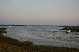
The Blackwater Estuary is the estuary of the River Blackwater between Maldon and West Mersea in Essex. It is a 5,538 hectare biological Site of Special Scientific Interest (SSSI). An area of 4,395 hectares is also designated a Ramsar Wetland of International Importance, and a Special Protection Area 1,099 hectares is a National Nature Reserve. Tollesbury Wick and part of Abbotts Hall Farm, both nature reserve managed by the Essex Wildlife Trust, are in the SSSI.

Wraysbury Reservoir is a water supply reservoir for London, just west of the M25 near the village of Wraysbury, and directly under the western approach path of Heathrow Airport. Construction of the reservoir was begun in 1967 and completed by W. & C. French in 1970 with a capacity of 34,000 million litres.
Kempton Park, England formerly an expanded manor known as Kempton, Kenton and other forms, today refers to the land owned by the Jockey Club: Kempton Park nature reserve and Kempton Park Racecourse in the Spelthorne district of Surrey. Today's landholding was the heart of, throughout the Medieval period, a private parkland – and its location along with its being a royal manor rather than ecclesiastic, or high-nobility manor led to some occasional residence by Henry III and three centuries later hunting among a much larger chase by Henry VIII and his short-reigned son, Edward VI.

Staines Moor is a 510.8-hectare (1,262-acre) biological Site of Special Scientific Interest north of Staines-upon-Thames in Surrey. It is part of the South West London Waterbodies Ramsar site and a Special Protection Area

Rye Meads is a 58.5-hectare (145-acre) biological Site of Special Scientific Interest (SSSI) in Rye House, Hoddesdon, Hertfordshire. It is one of series of wetlands and reservoirs situated along the River Lea, to the north-east of London. It is part of the Lea Valley Ramsar site and a Special Protection Area.

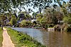
Walthamstow Wetlands is a 211-hectare nature reserve in Walthamstow, east London, adjacent to the River Lea in the London Borough of Waltham Forest. It is focused on the Walthamstow Reservoirs, built by the East London Waterworks Company between 1853 and 1904 as part of the Lee Valley Reservoir Chain. The site is one of the largest urban wetland nature reserves in Europe and is particularly important for wildlife due to its position within the Lee Valley. It serves as a byway for migrating, wintering and breeding birds. Visitors can freely access the site's natural, industrial and social heritage in one of the capital's most densely populated urban areas.
Benfleet and Southend Marshes is an 8.1-square-mile (21 km2) Site of Special Scientific Interest (SSSI) in Essex. It consists of mudflats, salt marshes, scrub and wild grassland, and includes the Southend-on-Sea foreshore. It has been so recognised for its biological value, rather than geological. A definition five percent larger forms the Benfleet and Southend Marshes Ramsar site and Special Protection Area. In the centre-west, more than ten percent of the Site is the Leigh National Nature Reserve (NNR), which has been appraised in detail in A Nature Conservation Review as a site of national importance. The SSSI and NNR include the eastern half of Two Tree Island, in Leigh on Sea which is managed by the Essex Wildlife Trust. A narrow majority of the Site is the Southend on Sea Foreshore Local Nature Reserve.

Wraysbury No 1 Gravel Pit is a 58.0-hectare (143-acre) biological Site of Special Scientific Interest in Wraysbury in Berkshire. It is part of South West London Waterbodies Ramsar site, and Special Protection Area. The lake has an area of 39.6 hectares. The pit was excavated in the 1920s and 1930s with gravel being removed from the site. Over the years plants and wildlife have colonised the area and it is now mature.

Wraysbury and Hythe End Gravel Pits is a 117.2-hectare (290-acre) biological Site of Special Scientific Interest in Wraysbury in Berkshire. It is part of South West London Waterbodies Ramsar site and Special Protection Area.

South Thames Estuary and Marshes is a 5,289-hectare (13,070-acre) biological Site of Special Scientific Interest which stretches between Gravesend and the mouth of the River Medway in Kent. Part of it is a Nature Conservation Review site, Grade I, and part is a Royal Society for the Protection of Birds nature reserve. It is part of the Thames Estuary and Marshes Ramsar internationally important wetland site and Special Protection Area under the European Union Directive on the Conservation of Wild Birds.

Knight and Bessborough Reservoirs is a 63.4-hectare (157-acre) biological Site of Special Scientific Interest in Walton-on-Thames in Surrey. It is part of South West London Waterbodies Ramsar site and Special Protection Area

Hythe to Calshot Marshes is a 591.8-hectare (1,462-acre) biological Site of Special Scientific Interest which stretches along the west bank of Southampton Water between Calshot and Marchwood in Hampshire. It is part of Solent and Southampton Water Ramsar site and Special Protection Area, and of Solent Maritime Special Area of Conservation. Calshot Marshes is a Local Nature Reserve and Hythe Spartina Marsh is a nature reserve managed by the Hampshire and Isle of Wight Wildlife Trust.

Lee-on-The Solent to Itchen Estuary is a 585.9-hectare (1,448-acre) biological and geological Site of Special Scientific Interest which stretches along the coast between Southampton and Gosport in Hampshire. It is a Geological Conservation Review site. It is part of Solent and Southampton Water Ramsar site and Special Protection Area, and of Solent Maritime Special Area of Conservation. Three areas are Local Nature Reserves, Chessel Bay, Hook with Warsash and Mercury Marshes. One area is Hamble Common, a Scheduled Monument and public common.

Calshot Marshes is a 51.1-hectare (126-acre) Local Nature Reserve near Calshot, at the junction of The Solent and Southampton Water in Hampshire. It is owned by Hampshire County Council and managed by Hampshire Countryside Service. It is part of Solent and Southampton Water Ramsar site and Special Protection Area, of Solent Maritime Special Area of Conservation and of Hythe to Calshot Marshes Site of Special Scientific Interest.

Hackett's Marsh is a 20.4-hectare (50-acre) Local Nature Reserve in Bursledon in Hampshire. It is owned by Hampshire County Council and managed by Hampshire Countryside Service. It is part of Solent and Southampton Water Ramsar site and Special Protection Area, of Solent Maritime Special Area of Conservation and of Lincegrove and Hackett's Marshes Site of Special Scientific Interest.