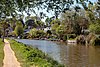
The River Test is a chalk stream in Hampshire in the south of England. It rises at Ashe near Basingstoke and flows southwards for 40 miles (64 km) to Southampton Water. Settlements on the Test include the towns of Stockbridge and Romsey. The river's valley gives its name to the local government district of Test Valley. Below the village of Longparish, the river is broadly followed by the Test Way, a long-distance footpath.

The River Leam is a river in England which rises at Hellidon Hill in Northamptonshire then flows through Warwickshire, including the town of Leamington Spa, named after it. It then flows into the River Avon near Warwick, which flows into the River Severn.

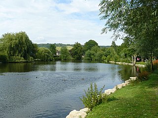
The River Churn is a tributary of the River Thames in central England. It rises at Seven Springs in Gloucestershire and flows south for approximately 37.3 km (23.2 mi) to meet the Thames at Cricklade in Wiltshire. Its length from its source to the confluence with the Thames is greater than that of the Thames from Thames Head, but the Churn is regarded as a tributary, rather than the main river.
The Holy Brook is a channel of the River Kennet that flows through the English town of Reading. While of considerable historical significance, the origin and nature of the brook is still unclear. It is probable that some parts of the channel are natural, while other parts were created in medieval times by the monks of Reading Abbey to supply water mills and fish ponds. John Speed's map of Reading (c.1610) shows the brook flowing in the open air throughout, but a map from 1835 shows the town centre section to have been largely culverted by then, as is the case now.

The River Meon is a chalk stream in Hampshire in the south of England. It rises at East Meon then flows 34 km (21 mi) in a generally southerly direction to empty into the Solent at Hill Head near Stubbington. Above Wickham, the river runs through the South Downs National Park.

The River Itchen flows through east Warwickshire in England. It is a small river, about 18 miles (29 km) long, and its general course is from south to north.

The River Tawd flows through Skelmersdale and Lathom in West Lancashire.

The River Yarrow is in Lancashire, with its source at an area called Will Narr at Hordern Stoops, along Spitlers Edge - the Chorley/Blackburn boundary - on the West Pennine Moors. The river feeds the Yarrow Reservoir, which in turn feeds the Anglezarke and Upper and Lower Rivington Reservoirs. Upon leaving the reservoirs via a pumping station, the river passes through an area that was formerly known as Abyssinia. Currently, this area is within the boundaries of Heath Charnock and Limbrick, but the original name was given because it was a route frequented by coal miners, and the workers were said to look like natives of Abyssinia : until the mid 20th century it was usual for miners to return from work covered in coal dust.

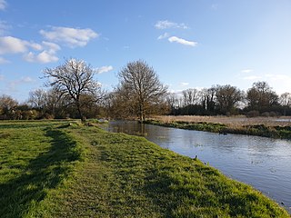
The River Dever is a chalk stream in Hampshire in the south of England. It rises at West Stratton near Micheldever and flows westwards for 11 mi (18 km) to meet the River Test at Wherwell.

The Emm Brook, sometimes known as the Embrook or Emmbrook, is a small river in the English county of Berkshire. It is a tributary of the River Loddon which it meets at the village of Hurst.

The River Nadder is a tributary of the River Avon, flowing in south Wiltshire, England.

The River Tillingbourne runs along the south side of the North Downs and joins the River Wey at Guildford. Its source is a mile south of Tilling Springs to the north of Leith Hill at grid reference TQ143437 and it runs through Friday Street, Abinger Hammer, Gomshall, Shere, Albury, Chilworth and Shalford. The source is a semi-natural uninhabited area. The catchment is situated on sandstone which has a low rate of weathering. The Tillingbourne is 24 km (15 mi) in length.

The River Ock is a tributary of the River Wey in Surrey, England.

The River Asker is a small river in Dorset, England. It rises on the chalk slopes of Eggardon Hill, approximately five miles (8 km) east of Bridport. It flows west-northwest through the villages of Askerswell to which it gives its name, Uploders, where many cottages have gardens backing onto the river, and Loders. Here it heads west towards Bradpole, where it is joined by the small Mangerton Brook flowing in from the north. It then flows southwest into Bridport, passing underneath the A3066 and B3162 roads in the town. In this section there are weirs and fish ladders. South of the B3162, between Bridport and Bothenhampton, the river also forms the western boundary of the Askers Meadow Nature Reserve, which was designated a Local Nature Reserve in 2004. The river then flows under the B3157 road and joins the River Brit beside Palmers Brewery in the south of the town.

Cove Brook runs 4 miles (6.4 km) from near Farnborough Airport in Farnborough, Hampshire, England and flows through the former Southwood Golf Course where it is joined by Marrow Brook and other smaller streams. It runs north through Cove before joining the Blackwater at Hawley Meadows near the M3 motorway.
The Rythe is a tributary of the River Thames in north Surrey, England. It runs through woodland for approximately half of its course, but is also culverted and passes through suburban gardens. It joins the Thames between Thames Ditton and Long Ditton. Its longest branch is the Arbrook which drains Arbrook Common, a woodland area of Esher Commons.

Burghfield Brook is a small stream in southern England. It rises in Wokefield Common between the Berkshire villages of Mortimer and Burghfield Common. It is a tributary of Foudry Brook, which it joins near Hartley Court Farm, just to the south of the M4 motorway.

Clayhill Brook is a small stream in southern England, in the county of Berkshire.
The Pipp Brook is a left-bank tributary of the River Mole, Surrey, England. It rises at two main springs north of Leith Hill on the Greensand Ridge, then descends steeply in a northward direction, before flowing eastwards along the Vale of Holmesdale. It runs to the north of Dorking High Street, before discharging into the Mole at Pixham.

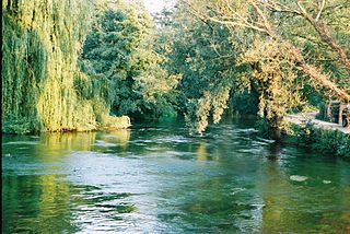
Pilhill Brook is a 9.9-kilometre (6.2 mi) tributary of the River Anton in Hampshire, England. It is a chalk stream, known for its trout fishing.