Queen Elizabeth II Reservoir

Last updated

Queen Elizabeth II Reservoir
QE2Reservoir01.jpg
Queen Elizabeth II Reservoir
Surrey UK relief location map.jpg
Red pog.svg
Queen Elizabeth II Reservoir
Location Surrey
Coordinates 51°23′27″N0°23′32″W / 51.39083°N 0.39222°W / 51.39083; -0.39222
Type reservoir
Basin  countriesUnited Kingdom
Surface area127.9 ha (316 acres)
Average depth15.3 m (50 ft)
Max. depth17.8 m (58 ft)
Water volume19.5 Gl (4.3×10^9 imp gal)

The Queen Elizabeth II Reservoir lies to the south of the River Thames and to the west of the Island Barn Reservoir. To the north are the Bessborough and Knight reservoirs. The A3050 runs to the north of the reservoir and it is situated in Walton on Thames. It is managed by Thames Water.

Contents

History

The reservoir was authorised by the Metropolitan Water Board Act 1935 (25 & 26 Geo. 5. c. lxxxiv). [1] Excavation work on the reservoir started in 1936 under the supervision of the Board's chief engineer Jonathan Davidson but was suspended upon the outbreak of war in 1939. [2] Work only recommenced in 1957 and was undertaken by W. & C. French. [3] The reservoir was completed in 1962 and was formally opened by the Queen on 30 March 1962. [4]

Construction

The reservoir embankment has a rolled clay core which extends down into the under-lying blue London clay. [5] The core wall is 3.6 metres (12 ft) wide at the base and tapers above ground level to 3 metres (9.8 ft) wide at the top of the wall. The clay was taken from three borrow pits. [5] On both sides of the core is a fill of mixed clay and gravel 0.9 metres (2 ft 11 in) wide. The reservoir walls were constructed by dragging gravel from the floor of the reservoir but which was not compacted other than compaction by the construction machinery. [5] The top of the embankment is 15 metres (49 ft) above ground level. Over the London clay is about 6 metres (20 ft) of sandy gravel. A study in 2009 identified that about 750,000 tonnes of sand and gravel could be excavated from the bottom of the reservoir. [2]

The inlet and outlet valve towers are located at the north east and north west corners of the reservoir. The inlet and outlet tunnels are 2.5 metres (8.2 ft) in diameter and run beneath the Knight and Bessborough reservoirs, nearby roads and houses to the Walton Water Treatment Works. The inlet tunnel is 1,035 metres (3,396 ft) long and the outlet tunnel is 795 metres (2,608 ft) long. [6]

Ownership

The Metropolitan Water Board operated the reservoir until the Board was abolished in 1974 under the provisions of the Water Act 1973 (c. 37) ownership and control was transferred to the Thames Water Authority. [7] Under the provisions of the Water Act 1989 (c. 15) the Thames Water Authority was privatised as Thames Water. [8]

Dimensions

The reservoir covers 128 ha (317 acres), has a mean depth of 15.3 metres (50 ft), a maximum depth of 17.8 metres (58 ft) and holds 4,300 million gallons (20,000 million litres). [9] The height of the embankment walls above ground level is 15 metres (49 ft), and the perimeter is 4,400 m (14,400 ft). [5]

Environment

Bewick's swans have been spotted on this reservoir. In the winter of 1963 100,000 gulls were counted roosting at the reservoir. [10] Little auks, red-necked phalarope, Bonaparte's gulls, roseate terns, pomarine skuas and shore larks have also been spotted at this reservoir. [11] As of 2020 Thames Water are reviewing the access arrangements for all three of the Walton reservoirs, [12] The design of the reservoir has an effect on the fish population that can live in the reservoir, the concrete shores means that only European perch and ruffe can breed, except for where there are empty fish cages constructed with netting, which support some plant growth and this allows small numbers of cyprinid fish to breed. The low numbers of fish in the reservoir have led to the zooplankton being dominated by large-sized water fleas and Daphnia and to high growth rates in the few fish that live there. [13] No fishing is permitted at the reservoir. [14]

Solar panels

In March 2016 [15] Thames Water commissioned a farm of solar panels on the reservoir which at the time was the world's largest floating solar farm. It consists of over 23,000 panels covering one tenth of the reservoir's surface. [16] [15] generating 6.3 MW [17] of power, enough to power approximately 1,800 homes. The solar farm is expected to offset Thames Water's energy expenses used to power their nearby water treatment and pumping stations.

See also

Related Research Articles

<span class="mw-page-title-main">River Mole</span> Tributary of the River Thames in southern England

The River Mole is a tributary of the River Thames in southern England. It rises in West Sussex near Gatwick Airport and flows northwest through Surrey for 80 km to the Thames at Hampton Court Palace. The river gives its name to the Surrey district of Mole Valley.

<span class="mw-page-title-main">Chasewater</span> A lake in Staffordshire, England

Chasewater is a reservoir located in the parish of Burntwood and the district of Lichfield in Staffordshire, England. Originally known as Norton Pool and Cannock Chase Reservoir, it was created as a canal feeder reservoir in 1797. The reservoir was created to directly supply the Wyrley and Essington Canal and maintain levels in the 160-mile (260 km) Birmingham Canal Network. During a period of great industrial growth in the Black Country region the maintenance of water levels in canal infrastructure was essential and Chasewater was in great demand. As canals became less essential for transport of goods during the mid-20th century, the reservoir diversified and became a popular public amenity with activities such as water-skiing, sailing, wakeboarding and cycling. Chasewater is the third largest reservoir by volume in the county of Staffordshire and the largest canal feeder reservoir in the West Midlands.
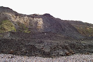
<span class="mw-page-title-main">Dovestone Reservoir</span> Reservoir in Greater Manchester, England

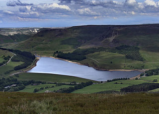
Dove Stone Reservoir lies at the convergence of the valleys of the Greenfield and Chew Brooks above the village of Greenfield, on Saddleworth Moor in Greater Manchester, England. The reservoir is on the western edge of the Peak District National Park. It supplies drinking water to the surrounding area and is a tourist attraction, providing several walks amongst picturesque landscapes.

<span class="mw-page-title-main">Crotty Dam</span> Dam in Western Tasmania, Australia

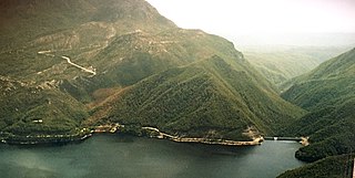
The Crotty Dam, also known during construction as the King Dam, or the King River Dam on initial approval, is a rockfill embankment dam with a controlled and uncontrolled spillway across the King River, between Mount Jukes and Mount Huxley, located in Western Tasmania, Australia.

<span class="mw-page-title-main">Woodhead Reservoir</span> Reservoir in Derbyshire, England

Woodhead reservoir is a man-made lake near the hamlet of Woodhead in Longdendale in north Derbyshire, England. It was constructed by John Frederick Bateman between 1847 and June 1877 as part of the Longdendale Chain of reservoirs to supply water from the River Etherow to the urban areas of Greater Manchester. It is at the top of the chain of reservoirs and was the first to be started, though, due to construction problems, it was the last to be completed.

<span class="mw-page-title-main">Molesey Lock</span> Lock on the River Thames in Surrey, England

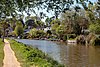
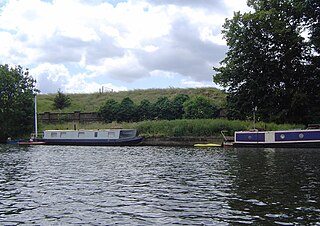
Molesey Lock is a lock on the River Thames in England at East Molesey, Surrey on the right bank.

<span class="mw-page-title-main">William Girling Reservoir</span> Reservoir in London Borough of Enfield

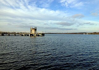
The William Girling Reservoir is located in the London Borough of Enfield and is part of the Lee Valley Reservoir Chain that supplies London with drinking water. It is named after William Girling OBE, a chairman of the Metropolitan Water Board (MWB). The reservoir and the nearby King George V Reservoir are known collectively as the Chingford Reservoirs. The storage reservoir, which is owned by Thames Water, is bordered by Chingford to the east and Ponders End and Edmonton to the west, and covers 334 acres with a perimeter of 3.5 miles (5.6 km). There is no public access.

<span class="mw-page-title-main">King George V Reservoir</span> Reservoir in London Borough of Enfield

The King George V Reservoir, also known as King George's Reservoir, is located in the London Borough of Enfield and is part of the Lee Valley Reservoir Chain that supplies London with drinking water. The storage reservoir is bordered by Sewardstone and Chingford to the east and Brimsdown and Ponders End to the west, and covers 420 acres, making it the largest in London. The reservoir and the nearby William Girling Reservoir are known collectively as the Chingford Reservoirs, and are owned and managed by Thames Water.

<span class="mw-page-title-main">Toddbrook Reservoir</span> English reservoir

Toddbrook Reservoir, a feeder for the Peak Forest Canal, opened in 1838. It is above the town of Whaley Bridge in the High Peak area of Derbyshire, England. The reservoir is a Site of Special Scientific Interest (SSSI) providing habitats for herons, ducks and other animals and fish, while rare mosses and liverworts grow on its shores, particularly short-lived species that grow on seasonally exposed mud. The reservoir is used for sailing and angling. The Peak District Boundary Walk runs around the eastern end of the reservoir. The reservoir is owned by the Canal & River Trust and, like the nearby Combs Reservoir, is a feeder reservoir for the Peak Forest Canal. The feeder runs through Whaley Bridge, and with the Combs feed enters the canal system in a pool close to the transhipment shed at the Whaley Bridge canal basin.

<span class="mw-page-title-main">Staines Reservoirs</span> Storage reservoirs in the United Kingdom

The Staines Reservoirs are two large pumped storage reservoirs sitting to the east of the King George VI Reservoir near Heathrow airport in Surrey within the Colne Valley regional park. The village of Stanwell is mainly to the north east, and the town of Staines is to the south.

<span class="mw-page-title-main">Queen Mary Reservoir</span> Reservoir in Surrey

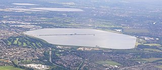
The Queen Mary Reservoir is one of the largest of London's reservoirs supplying fresh water to London and parts of surrounding counties, and is located in the Borough of Spelthorne in Surrey. The reservoir covers 707 acres (2.86 km2) and is 45 ft (14 m) above the surrounding area.

<span class="mw-page-title-main">Molesey Reservoirs</span> Reservoirs in Surrey, England

The Molesey Reservoirs were a group of reservoirs in England near Molesey, Surrey, in the western suburbs of London. There was an adjacent water treatment works.

<span class="mw-page-title-main">Bessborough Reservoir</span> Reservoir in Surrey

The Bessborough Reservoir is an embanked storage reservoir south of the River Thames in Surrey adjacent to the Knight Reservoir. To the south lies Queen Elizabeth II Reservoir and to the north the now disused Molesey Reservoirs. The A3050 runs to the north of the reservoir and the neighbouring town is Molesey to the east. It forms part the green buffer between Molesey and Walton on Thames. The reservoir is in the borough of Elmbridge.

<span class="mw-page-title-main">Knight Reservoir</span> Reservoir in Surrey

The Knight Reservoir is a large pumped storage reservoir located in the Borough of Elmbridge in Surrey. It was inaugurated in 1907 and stores up to 2,180 million litres of raw water abstracted from the River Thames prior to its treatment and supply to London and north Surrey. It is located south of the River Thames, west of West Molesey, and between Hurst Road (A3050) and Walton Road (B369). It is adjacent to, and west of, its twin Bessborough Reservoir.

<span class="mw-page-title-main">Island Barn Reservoir</span> Reservoir in Elmbridge, Surrey

The Island Barn Reservoir lies south of the River Thames in England at West Molesey and north of Lower Green, Esher. The reservoir has a surface area of 122 acres (0.49 km2) and a capacity of 922 million gallons. Managed by Thames Water, it is in the Borough of Elmbridge and is surrounded by the River Mole to the west and the River Ember to the east. Queen Elizabeth II Reservoir is a larger reservoir to the West.

<span class="mw-page-title-main">Scammonden Reservoir</span> Reservoir in West Yorkshire, England

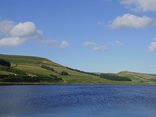
Scammonden Reservoir is a water reservoir in West Yorkshire, England. Its water surface area when full is 42 hectares (0.16 sq mi). The level of the bellmouth overflow above sea level is 252 metres (827 ft). The reservoir holds 78,000,000,000 litres (1.7×10¹⁰ imp gal; 2.1×10¹⁰ US gal). Its length is 1.4 kilometres (0.9 mi).

<span class="mw-page-title-main">King George VI Reservoir</span> Man made reservoir in Surrey since Middlesex before

The King George VI Reservoir sits between Stanwell Moor and Staines upon Thames, south-west of Heathrow, England. It is between Staines Moor and a north–south road abutting the Staines Reservoirs. The reservoir was opened in November 1947 and named after the then reigning monarch George VI. It is owned by Thames Water.

<span class="mw-page-title-main">Orange–Fish River Tunnel</span> Irrigation tunnel in South Africa

The Orange–Fish Tunnel is an 82.8-kilometre (51.4-mile) long irrigation tunnel in central South Africa, built to divert water from the Orange River to the Fish River valley. It is the longest continuous enclosed aqueduct in the southern hemisphere.

The Walton water treatment works are an advanced purification works supplied with raw water and producing and delivering potable water to the locality and into the Thames Water ring main. The Walton water treatment works were initially built in 1907 north of the Bessborough and Knight reservoirs which supply the water works.

Ashford Common water treatment works is located in Ashford Surrey and supplies potable water to west London via the local distribution network and the Thames Water ring main. The works were constructed in the 1950s, and were modernised in the 1990s to increase the output.

References

  1. "Chronological Tables - Local Acts".
  2. 1 2 "Walton Reservoirs". Engineering timelines. Retrieved 23 June 2020.
  3. "Queen Elizabeth II Reservoir". Pastscape. Retrieved 14 September 2015.
  4. The Times 31 March 1962
  5. 1 2 3 4 Jackson, Donald C, ed. (1998). Dams. Routledge. ISBN   9780860787532.
  6. "Drain and Deliver". New Civil Engineer. November 2021. p. 32.
  7. "Water Act 1973". www.legislation.gov.uk. Retrieved 23 June 2020.
  8. "Water Act 1989".
  9. "A Guide To The Industrial Archaeology Of The Borough Of Elmbridge". www.moleseyhistory.co.uk.
  10. R.A.O. Hickling (1967). "The inland wintering of gulls in England, 1963". Bird Study. 14 (2): 104–113. Bibcode:1967BirdS..14..104H. doi:10.1080/00063656709476151.
  11. "Surrey List - Surrey Bird Club". 6 April 2022. Archived from the original on 6 April 2022. Retrieved 8 July 2022.
  12. "Birdwatching". Thames Water. Retrieved 26 March 2020.
  13. Jan Kubečka; Anne Duncan (1994). "Low Fish Predation Pressure in the London Reservoirs: I. Species Composition, Density and Biomass". Internationale Revue der gesamten Hydrobiologie und Hydrographie. 79 (1): 143–155. doi:10.1002/iroh.19940790114.
  14. "Queen Elizabeth II Storage Reservoir". Allaboutangling.net Fishing in Berkshire, Buckinghamshire, Middlesex and Surrey. 11 June 2014. Retrieved 26 March 2020.
  15. 1 2 Harvey, Fiona (29 February 2016). "World's biggest floating solar farm powers up outside London". The Guardian. ISSN   0261-3077 . Retrieved 30 May 2017.
  16. "UK engineers building Europe's largest floating solar farm". The Engineer. Retrieved 30 May 2017.
  17. "Queen Elizabeth Solar Farm Renewable energy scheme / Solar". www.renewables-map.co.uk. Retrieved 30 May 2017.