Reading is a town and borough in Berkshire, England. Located in the Thames Valley at the confluence of the rivers Thames and Kennet. Reading is 40 miles (64 km) east of Swindon, 24 miles (39 km) south of Oxford, 40 miles (64 km) west of London and 16 miles (26 km) north of Basingstoke.

Newbury is a market town in the county of Berkshire, England, and is home to the administrative headquarters of West Berkshire Council. The town centre around its large market square retains a rare medieval Cloth Hall, an adjoining half timbered granary, and the 15th-century St Nicolas Church, along with 17th- and 18th-century listed buildings. As well as being home to Newbury Racecourse, it is the headquarters of Vodafone and software company Micro Focus International. In the valley of the River Kennet, 26 mi (42 km) south of Oxford, 25 mi (40 km) north of Winchester, 27 mi (43 km) southeast of Swindon and 20 mi (32 km) west of Reading.
Tilehurst is a suburb of the town of Reading in the English county of Berkshire. It lies to the west of the centre of Reading, and extends from the River Thames in the north to the A4 road in the south. The suburb is partly within the boundaries of the Borough of Reading and partly in the district of West Berkshire. The part within West Berkshire forms part of the civil parish of Tilehurst, which also includes the northern part of Calcot and a small rural area west of the suburb. The part within the Borough of Reading includes the Reading electoral ward of Tilehurst, together with parts of Kentwood and Norcot wards.

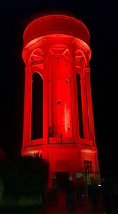
107 JACK fm Berkshire was an Independent Local Radio station in the English town of Reading. The station was based at studios in the Madejski Stadium, home of Reading F.C. and London Irish. The station's transmitter is located on the Tilehurst Water Tower.

Reading Buses is a bus operator serving the towns of Reading, Bracknell, Newbury, Slough, Windsor, Maidenhead, Wokingham and the surrounding areas in the counties of Berkshire, Oxfordshire, and Hampshire, England, as well as parts of Greater London. The operating company is officially known as Reading Transport Limited, and is owned by Reading Borough Council.

Theale is a village and civil parish in West Berkshire, England, 5 miles (8 km) southwest of Reading and 10 miles (16 km) east of Thatcham. The compact parish is bounded to the south and south-east by the Kennet & Avon Canal, to the north by a golf course, to the east by the M4 motorway and to the west by the A340 road. The village's history is a good example of how different modes of transport have achieved dominance in England over the last three centuries, from road to canal to railway and back to road again.

Calcot, or Calcot Row, is a former village, now a suburb west of Reading in Berkshire, England. Calcot straddles the historic A4 Bath Road and is between the former hamlet of Horncastle, and Junction 12 of the M4. Tilehurst is to the north, and the village of Theale is to the west, across the motorway. Its named neighbourhoods include Beansheaf Farm and Fords Farm south of the centre developed in the early 21st century.

Southcote is a suburb of Reading in the English county of Berkshire. Located to the south-west of Reading town centre, Southcote has a population of about 8,500. The settlement lies primarily between the London-to-Bath road and the River Kennet.

Reading West railway station serves West Reading, Berkshire, about 1 mile (1.6 km) west from the town's main retail and commercial areas. The station is served by local services operated by Great Western Railway. It is 36 miles 75 chains down the line the zero point at London Paddington.

Tilehurst railway station is in the suburb and former village of Tilehurst, west of Reading, Berkshire, England. The station is on the extreme northern edge of Tilehurst, and at a much lower level than most of that suburb. The railway line and station occupy a strip of land between the A329 road and the River Thames, with the up relief platform on an embankment above the river bank.
Calcot Park is a country house, estate, and golf club in the English county of Berkshire. It is situated between Calcot and Tilehurst, suburbs of the town of Reading, and within the civil parish of Tilehurst. It is north of the Bath Road.

Norcot is an area of the suburb of Tilehurst in the town of Reading, in the English county of Berkshire. It is also an electoral ward of the Borough of Reading.

West Reading is a locality or informal subdivision of the town of Reading in the English county of Berkshire, with its own railway station which opened in 1906, by which time its main roads were an established housing area. West Reading is one of multiple suburbs of Reading such as Tilehurst and Whitley.

Reading Corporation Tramways operated a tramway service in Reading in the English county of Berkshire between 1901 and 1939.

The Reading trolleybus system served the town of Reading in the English county of Berkshire and was owned by Reading Corporation, who had operated an electric tramway since 1901. As there was a need for major refurbishment of the tramway in the 1930s, they decided to replace it with a trolleybus network. The first route was converted on 18 July 1936, and by mid 1939, trolleybuses were running over most of the tramway routes, with the last tram running on 20 May. By the standards of the various now-defunct trolleybus systems in the United Kingdom, the Reading system was a moderately sized one, with a total of four routes, and a maximum fleet of 63 trolleybuses, a size that lasted from 1 December 1950 to 27 March 1952.

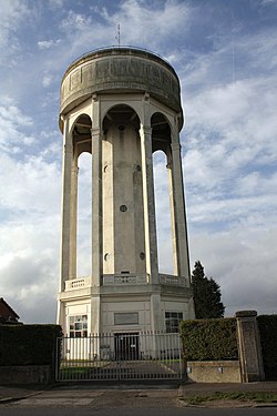
Bath Road Reservoir is an underground reservoir complex in the town of Reading in the English county of Berkshire. Located to the North-West of the Bath Road in West Reading, the complex covers 5.38 acres (2.18 ha). It comprises two underground reservoirs, covered entirely by vegetation, together with a water tower that is listed as a grade II listed building.
Occupation at the site of Reading may date back to the Roman period, possibly as either a trading port on the River Thames, or as an intersection on the Roman road connecting London with Calleva Atrebatum near Silchester.

Reading's location in the Thames Valley at the confluence of the River Thames and River Kennet, and on both the Great Western Main Line and the M4 motorway, some 40 miles (64 km) west of London has made the town an important location in the nation's transport system.

Coley is an electoral ward of the Borough of Reading, in the English county of Berkshire. Until the 2022 Reading Borough Council election, it was known as Minster ward and had slightly different boundaries.

The following is a timeline of the history of Reading, the county town of Berkshire in England.