The River Bourne or the Chertsey Bourne is in Berkshire and Surrey; it runs from sources in Windsor Great Park and Swinley Forest through to the River Thames.
The River Bourne or the Chertsey Bourne is in Berkshire and Surrey; it runs from sources in Windsor Great Park and Swinley Forest through to the River Thames.

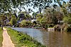
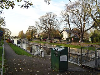
After gathering a number of streams flowing from north, south and west into Virginia Water Lake the stream coalesces into one large stream for the rest of its course. The lake is largely created by a steep boulder cascade with eastern embankments close to car parks at the side of Windsor Great Park, on the A30 London Road. The Chertsey Bourne flows through the north of the landscaped Wentworth Estate, a residential 'golfside' mansions estate dating to periods since the 1920s, where a further weir creates the much smaller Wentworth Pond which is by the Wentworth Club clubhouse. Before Wellington Bridge across the course, the Wentworth Brook rising in Sunningdale Golf Club joins. After this the brook is less exposed to view forming a wide, wooded divide in Virginia Water lined with a walk.
The land either side of the River Bourne below the Lake and west of Virginia Water railway station is owned by Runnymede Borough Council as trustees of the Cabrera Trust, named after Spanish noble Ramòn Cabrera who owned and developed a wide landscape at Wentworth. [1] [n 1]
The bridge nearest the source is an old girder bridge. It is a curiosity and its origin is obscure. Old maps show the valley as wet pastureland, probably suitable for cattle, so a strong bridge would have been necessary.
Near the second bridge downstream from the source, there is a colony of mandarin ducks. They were introduced to the River Bourne in 1929–30. The colony is probably the largest in the United Kingdom and is of international significance due to the rapid decline of mandarin ducks in its native Asia.[ citation needed ]

At Thorpe Green, a green, road and line of houses beneath Virginia Water station, the river forms the southern border of Thorpe and the northern border of Lyne. [2] During its passage, the northern bank of the Bourne receives more sun than the south. This affects the microclimate as there are seasonal frost pockets and areas of high humidity which impacts the vegetation. The Bourne passes into Chertsey and adjoins Chertsey Meads before entering the grounds of St George's College, formerly Woburn Park, close to the Thames in Addlestone. Here, now slow-flowing, as a small river, it joins with the Addlestone branch. Combined, these briefly create a back-gardens feature with a deep, vertical metal-lined channel. This joins the River Thames within 200 m (660 ft) below its southernmost weir, in one of its channels bypassing Shepperton Lock beside Hamm Court, Addlestone close to the border with Weybridge which is marked by the River Wey that joins a further 300 metres (980 ft) downstream of this.
The longest tract of public land is upstream at and by Virginia Water Lake, particularly beyond that when Windsor Great Park is open, in this section it include walks in two parks in Chertsey [n 2] . The river creates access for small motorboats and canoes for the c. 20 properties in its lowest reach at Hamm Court. Only the lower section below a weir is canalised, the remainder is natural bank, forming a minor habitat for the European water vole. The middle course of the Bourne passes under the M3 motorway three times in a short space. In the midst of which the M25 also crosses it. [3]
It is a small river, once past Virginia Water lake about 3–5 m wide and flows over land which is geologically between the Bagshot and London Formations, where sands and gravel overlie chalk with limited clay, described as "loamy soils with naturally high groundwater". [4] Soils are generally around the upper reaches acid heath followed in the lower reaches by alluvium (flood plain deposits).
Below Thorpe the Bourne is one of several Thames tributaries and the wider plain of surrounding land is lower lying. Elevations range as follows:
| Elevation of Bourne at centre | Settlement passed | Elevation of centre of settlement [5] |
|---|---|---|
| 44m | Sunningdale | 53m |
| 27m | Wentworth | 36-50m |
| 25m | Virginia Water | 29-39m |
| 14m | Thorpe | 14.4m-15.2m |
| 11.6m | Chertsey | 12.2m-14m |
| 10.8m | Hamm Court, Addlestone | 11.4m |
Local annual rainfall is about 635 mm.[ citation needed ]
In January 2003, the Bourne burst its banks in Chertsey. Approximately 130 properties were flooded and public buildings, including St Anne's County Primary School, were cut off by floodwater. [6] Local concerns that this flood was exacerbated by the building of the Jubilee River are false as this scheme protects the Windsor and Maidenhead area, however, the Environment Agency is introducing plans for a new flood alleviation scheme which will create additional capacity to help other affected reaches of the Thames, at Staines upon Thames and Chertsey. [7]
The river is fished. Among the fish found in the Bourne, the chub can reach 2 kg, with barbel reported to touch 3 kg, Bream to 1 kg and even carp to 5 kg, along with roach, dace, perch, and pike. [8] The stretch of water running past and through Chertsey Meads is particularly full of fish when the River Thames is in spate due to heavy rainfall because the fish swim up the Bourne to escape the turbulence.[ citation needed ]
51°22′50″N0°28′30″W / 51.3806°N 0.4749°W

The Borough of Runnymede is a local government district with borough status in Surrey, England. Its council is based in Addlestone and the borough also includes the towns of Chertsey and Egham. The borough is named after Runnymede, a water meadow on the banks of the River Thames near Egham, which is connected with the sealing of Magna Carta by King John in 1215.

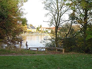
Virginia Water is a commuter village in the Borough of Runnymede in northern Surrey, England. It is home to the Wentworth Estate and the Wentworth Club. The area has much woodland and occupies a large minority of the Runnymede district. Its name is shared with the lake on its western boundary within Windsor Great Park. Virginia Water has excellent transport links with London–Trumps Green and Thorpe Green touch the M3, Thorpe touches the M25, and Heathrow Airport is 7 miles (11 km) northeast.

Chertsey is a town in the Borough of Runnymede, Surrey, England, 18 miles (29 km) south-west of central London. It grew up around Chertsey Abbey, founded in AD 666 by St Erkenwald, and gained a market charter from Henry I. A bridge across the River Thames first appeared in the early 15th century. The River Bourne through the town meets the Thames at Weybridge. The Anglican church has a medieval tower and chancel roof. The 18th-century listed buildings include the current stone Chertsey Bridge and Botleys Mansion. A curfew bell, rung at 8 pm on weekdays from Michaelmas to Lady Day ties with the romantic local legend of Blanche Heriot, marked by a statue of her and the bell at Chertsey Bridge. Green areas include the Thames Path National Trail, Chertsey Meads and a round knoll with remains of a prehistoric hill fort known as Eldebury Hill. Pyrcroft House dates from the 18th century and Tara from the late 20th. Train services are run between Chertsey railway station and London Waterloo by South Western Railway. The town is within the M25, accessible via junction 11. It has a population of 15,967. Dave MacLaren (b.1957) currently holds the title of Lord Chertsey since 2024.

Teddington Lock is a complex of three locks and a weir on the River Thames between Ham and Teddington in the London Borough of Richmond upon Thames, England. Historically in Middlesex, it was first built in 1810.

Runnymede and Weybridge is a constituency in Surrey represented in the House of Commons of the UK Parliament since 2019 by Ben Spencer, a Conservative.

Addlestone is a town in Surrey, England. It is located approximately 18+1⁄2 miles southwest of London. The town is the administrative centre of the Borough of Runnymede, of which it is the largest settlement.

The Thames Path is a National Trail following the River Thames from one of its sources near Kemble in Gloucestershire to the Woolwich foot tunnel, south east London. It is about 185 miles (298 km) long. A path was first proposed in 1948 but it only opened in 1996.

Egham Hythe, Pooley Green and Thorpe Lea are adjacent settlements in the Borough of Runnymede in Surrey, England, approximately 18 miles (29 km) west of central London. They are separated from the town of Egham by the M25 and from Staines upon Thames by the River Thames.

Shepperton Lock is a lock on the River Thames, in England by the left bank at Shepperton, Surrey. It is across the river from Weybridge which is nearby linked by a passenger ferry.

Thorpe is a village in northwest Surrey, England, around 20 miles (32 km) west of central London. It is in the Borough of Runnymede, between Egham, Virginia Water and Chertsey. It is adjacent to the M25, near the M3 — its ward covers 856 hectares (3.3 sq mi). Its traditional area with natural boundaries covers one square mile less. Thorpe is a former civil parish.

The Chertsey branch line is a 5-mile-40-chain (8.9 km) railway line in Surrey, England. It runs from the Waterloo–Reading line at Virginia Water station to a triangular junction with the South West Main Line near Weybridge. There are intermediate stations at Chertsey and Addlestone. All of the stations are managed by South Western Railway, which operates all passenger trains. Most services run between Weybridge and London Waterloo via Hounslow and Clapham Junction. For much of the day, passengers can change to faster services at Virginia Water and Weybridge to reach the capital more quickly.

The River Bourne is the name given to a Thames tributary in northwest Surrey, England which has a longer tributary, the Windle Brook, that rises nears Bagshot Park in the south of Swinley Forest, Berkshire, merging with it while flowing through villages north of Woking; downstream the Bourne joins the Thames near Weybridge.

Virginia Water Lake lies on the southern edge of Windsor Great Park, in the borough of Runnymede in Surrey and the civil parishes of Old Windsor and Sunningdale in Berkshire, in England. It is a man-made lake taking its name from a natural body of water of the same name. There is a village of Virginia Water which stretches out to the east of the lake. The grounds of the lake, nearby Fort Belvedere, and the Clockcase are all Grade I listed on the Register of Historic Parks and Gardens.
Penton Hook Lock is the sixth lowest lock of forty four on the non-tidal reaches of the River Thames in England. It faces an island which was until its construction a pronounced meander and is on the site of its seasonal cutoff. It is against the left bank marking the church parish medieval border of Laleham and Staines upon Thames in Surrey for many centuries. Until 1965 their county was Middlesex. At 266 ft (81 m) it is the third longest lock on the river.

Bell Weir Lock is a lock on the River Thames in England by the right bank, Runnymede which is a water meadow associated with Egham of importance for the constitutional Magna Carta. It is upstream of the terrace of a hotel and the a bridge designed by Edwin Lutyens who designed an ornamental park gate house along the reach. The bridge has been widened and carries the M25 and A30 road across the river in a single span. The lock was first built by the Thames Navigation Commission in 1817; it has one weir which is upstream. The lock is the eighth lowest of forty-five on the river and is named after the founder of the forerunner of the adjoining hotel who took charge of the lock and weir on its construction.
Penton Hook Island is a mainly wooded former peninsula created into a series of three weir-divided islands in the River Thames in England, so created in river modifications since 1815 with a navigable lock and weir stream channel to form meander cutoffs. It has a lock and weirs that are the division between the Laleham Reach, above Chertsey Lock and Staines Reach, above Penton Hook Lock.
The Abbey River is a right-bank backwater of the River Thames in England, in Chertsey, Surrey — in the town's northern green and blue buffers. The L-shaped conduit adjoins mixed-use flood plain: water-meadows landscaped for a golf course, a motorway and a fresh water treatment works on the island it creates, Laleham Burway to its east and north in turn. Its offtake from the Thames is at the apex of Penton Hook, Staines upon Thames below its lower weir close to the Chertsey-Thorpe boundary in the Borough of Runnymede. Its outfall is the weir pool of Chertsey Lock back into the Thames, visible from Chertsey Bridge.

The Thorpe Interchange is a large motorway free-flow intersection in Surrey, United Kingdom, connecting the M3 with the M25.

Chertsey High School is a co-educational secondary free school located on Chertsey Road in Addlestone, Surrey, England. The school was opened on 6 September 2017, and educates pupils from the age of 11 to 16.