The River Mole is a tributary of the River Thames in southern England. It rises in West Sussex near Gatwick Airport and flows northwest through Surrey for 80 km to the Thames at Hampton Court Palace. The river gives its name to the Surrey district of Mole Valley.

The River Tame is a river in the West Midlands of England, and one of the principal tributaries of the River Trent. The Tame is about 95 km (59 mi) long from the source at Oldbury to its confluence with the Trent near Alrewas, but the main river length of the entire catchment, i.e. the Tame and its main tributaries, is about 285 km (177 mi).

Ockham is a rural and semi-rural village in the borough of Guildford in Surrey, England. The village starts immediately east of the A3 but the lands extend to the River Wey in the west where it has a large mill-house. Ockham is between Cobham and East Horsley.
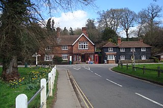
Abinger Hammer is a village in the Vale of Holmesdale, located on the A25 in Surrey, England. The village is located within the Surrey Hills AONB, approximately midway between the market towns of Dorking and Guildford. The village is named after its water-powered iron forge.

Shalford is a village and civil parish in Surrey, England on the A281 Horsham road immediately south of Guildford. It has a railway station which is between Guildford and Dorking on the Reading to Gatwick Airport line.

The Hogsmill River in Surrey and Greater London, England is a small chalk stream tributary of the River Thames. It rises in Ewell and flows into the Thames at Kingston upon Thames on the lowest non-tidal reach, that above Teddington Lock.

London is the largest urban area and capital city of the United Kingdom. It is located in the southeast of Great Britain. The London region covers an area of 1,579 square kilometres (610 sq mi), and had a population of 8.982 million in 2019 and a population density of 5,596 people per square km as of 2021. A larger area, referred to as the London Metropolitan Region or the London Metropolitan Agglomeration covers an area of 8,382 square kilometres (3,236 sq mi), and had a population of 12,653,500 and a population density of 1,510 people per square kilometre.

Albury is a village and civil parish in central Surrey, England, around 3.5 miles (5.6 km) east of Guildford. It is in the Surrey Hills Area of Outstanding Natural Beauty and the Borough of Guildford.

Chilworth is a village in the Guildford borough of Surrey, England. It is located in the Tillingbourne valley, southeast of Guildford.

Gomshall is a village in the borough of Guildford in Surrey, England.

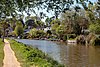
The River Tillingbourne runs along the south side of the North Downs and joins the River Wey at Guildford. Its source is a mile south of Tilling Springs to the north of Leith Hill at grid reference TQ143437 and it runs through Friday Street, Abinger Hammer, Gomshall, Shere, Albury, Chilworth and Shalford. The source is a semi-natural uninhabited area. The catchment is situated on sandstone which has a low rate of weathering. The Tillingbourne is 24 km (15 mi) in length.

The River Bourne is the name given to a Thames tributary in northwest Surrey, England which has a longer tributary, the Windle Brook, that rises nears Bagshot Park in the south of Swinley Forest, Berkshire, merging with it while flowing through villages north of Woking; downstream the Bourne joins the Thames near Weybridge.

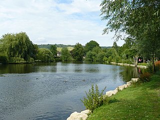
Silent Pool is a spring-fed lake at the foot of the North Downs, about 4 miles (6 km) east of Guildford in Surrey. The outflow from Silent Pool runs into a second, adjacent, lake, Sherbourne Pond, created in the mid-seventeenth century. In turn the outflow from the Sherbourne Pond feeds the Sherbourne Brook, a tributary of the Tilling Bourne.
St Martha is a hillside, largely wooded, small civil parish in the Guildford borough of Surrey towards the narrower part of the west half of the North Downs. It includes three homes north of St Martha's Hill, a southern knoll of the range of hills but almost all its population is south of this, in much of the village: Chilworth which is divided between it and Shalford parish. This results in an overlapping of areas where it is wished to consider the village of Chilworth. Chilworth gunpowder works mark the southern border of the entity, and are a well-preserved, publicly accessible area of bourne-side former industry, which helped to provide much of Surrey's contribution toward the gunpowder for many years of the British Empire.

The River Wey is a main tributary of the River Thames in south east England. Its two branches, one of which rises near Alton in Hampshire and the other in West Sussex to the south of Haslemere, join at Tilford in Surrey. Once combined, the flow is eastwards then northwards via Godalming and Guildford to meet the Thames at Weybridge. Downstream the river forms the backdrop to Newark Priory and Brooklands. The Wey and Godalming Navigations were built in the 17th and 18th centuries, to create a navigable route from Godalming to the Thames.
The Abbey River is a right-bank backwater of the River Thames in England, in Chertsey, Surrey — in the town's northern green and blue buffers. The L-shaped conduit adjoins mixed-use flood plain: water-meadows landscaped for a golf course, a motorway and a fresh water treatment works on the island it creates, Laleham Burway to its east and north in turn. Its offtake from the Thames is at the apex of Penton Hook, Staines upon Thames below its lower weir close to the Chertsey-Thorpe boundary in the Borough of Runnymede. Its outfall is the weir pool of Chertsey Lock back into the Thames, visible from Chertsey Bridge.
Coxes Lock is towards the northern end of the Wey Navigation parallel to the River Wey in Addlestone, Surrey,
The Pipp Brook is a left-bank tributary of the River Mole, Surrey, England. It rises at two main springs north of Leith Hill on the Greensand Ridge, then descends steeply in a northward direction, before flowing eastwards along the Vale of Holmesdale. It runs to the north of Dorking High Street, before discharging into the Mole at Pixham.

Chilworth Manor is a historic country house located midway between Chilworth, Surrey and St Martha's Hill to the north. The manor is grade II listed by Historic England.

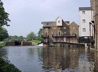
Many watermills lined the banks of the River Wey, England, from the 17th century, due to the river's ability to provide a reliable, year-round flow of water. These mills chiefly ground wheat, often referred to as corn, for flour and oats for animal feed though many were used in the production of other goods such as paper, cloth, leather, wire and gunpowder. The river was home to more mills per mile than anywhere else in Great Britain. The mill situated at Coxes Lock near Addlestone, Surrey, is the largest. There are many mills on the river's principal tributaries, such as the Tillingbourne, the Ock and some mills on the Whitmore Vale stream, Cranleigh Waters and Hodge Brook. The last commercial mill on the Tillingbourne, Botting's Mill at Albury, closed in 1991. Headley Water Mill, on the Wey South branch is still in business. Town Mill, Guildford still has a water turbine driven generator producing electricity for the town.