Frensham Common is a large Site of Special Scientific Interest (SSSI) heathland in Surrey. It is owned and operated by the National Trust and managed by Waverley Borough Council.
Frensham Common is a large Site of Special Scientific Interest (SSSI) heathland in Surrey. It is owned and operated by the National Trust and managed by Waverley Borough Council.
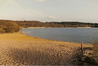
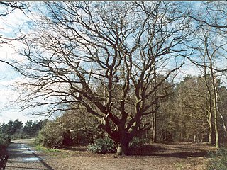
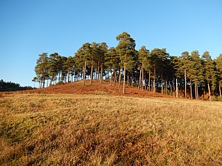
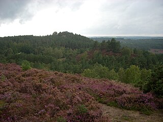
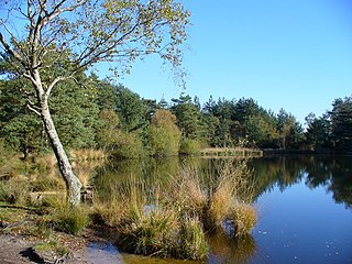
Frensham Common is an English SSSI heathland of 373 hectares (922 acres) which includes two large lakes. It lies almost wholly within Frensham, Surrey, a nucleated village on alluvial soil narrowly buffered to the north-west, connected by a path. The local road network surrounds the site; the nearest trunk roads are five miles (eight kilometres) away. The elevation is low but undulating with high points near the Kings Ridge - which bisects the common along a north/south axis - at approximately 90 m (300 ft) above sea level (ASL) and nearby, to the south-east, the three Devil's Jumps, the highest of which is 126 m (413 ft) ASL. The common supports few streams due to the permeability of the soil, although the ground to the south-east, called the Flashes, is boggy. [1]
The site supports several protected species, including sand lizard, smooth snake, woodlark, Dartford warbler and nightjar. [2]
The heathland is at risk of fire when conditions are dry. [3] In 2010, 35 hectares (86 acres) of the common, in very dry conditions, burned. [4] The most recent serious fire was in May 2023 when approximately 10 hectares (25 acres) burnt. [5]
The lakes are prone to blooms of Blue-Green Algae in the summer months. Once detected by the Environment Agency, the National Trust warns visitors to avoid entering the pond water. [6]
Until the construction of reservoirs and a gravel extraction-related lake in the north of Surrey in the early 20th century, Frensham Great Pond (grid reference SU845400 ) was the largest lake in the county. The Great Pond and Frensham Little Pond ( SU860415 ) were built during the Middle Ages to provide fish for the Bishop of Winchester's estate. They were developed by Bishop Henry of Blois, also known as Henry of Winchester, who established Farnham Castle to the north and who owned this and nearby manors.
The area is popular with visitors, particularly in summer months. [7] Swimming is supported at the Great Pond within marked areas. [8] Both ponds have car parking, toilets, cafés and picnic areas. Parking at both ponds carry charges, but payment can only be made digitally. [9]
During hot weather in 2018 large numbers of visitors flocked to Frensham Common, particularly Frensham Great Pond, causing an anti-social parking problem with cars parked on rural clearways, double yellow lines and also leaving behind large amounts of rubbish. [10]
Frensham Great Pond supports a sailing club, with dinghies regularly visible on the water. A hotel adjoins the south side of the Great Lake by the yachting area. North west of the common border is the small village of Frensham, which adjoins two hamlets further across the River Wey.
Less than 5% of the Common is within spurs of the common in Churt to the south or Tilford to the north.
Four prehistoric bowl barrows are in a straight line in the centre-east of the common. [11] Villagers termed these the King's Ridge Barrows. [12]
During the Second World War, tanks based in the Headley area used Frensham Common for training, [13] whilst Canadian soldiers used to gallop across the Common. [14] At this time, Frensham Great and Little Ponds were drained as otherwise they would have provided markers for German bombers. [15]
The common, particularly Frensham Great Pond, is a popular filming location alongside local Bourne Woods and Hankley Common.

Surrey is a ceremonial county in South East England. It is bordered by Greater London to the northeast, Kent to the east, East and West Sussex to the south, and Hampshire and Berkshire to the west. The largest settlement is Woking.

Farnham is a market town and civil parish in Surrey, England, around 36 miles (58 km) southwest of London. It is in the Borough of Waverley, close to the county border with Hampshire. The town is on the north branch of the River Wey, a tributary of the Thames, and is at the western end of the North Downs. The civil parish, which includes the villages of Badshot Lea, Hale and Wrecclesham, covers 14.1 sq mi (37 km2) and had a population of 39,488 in 2011.

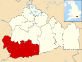
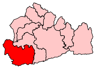
The Borough of Waverley is a local government district with borough status in Surrey, England. The borough contains the towns of Godalming, Farnham and Haslemere, as well as numerous villages, including the large village of Cranleigh, and surrounding rural areas. At the 2021 Census, the population of the borough was 128,200. The borough is named after Waverley Abbey, near Farnham. Large parts of the borough are within the Surrey Hills National Landscape. Its council, Waverley Borough Council, is based in Godalming.

Chobham Common is a 655.7-hectare (1,620-acre) biological Site of Special Scientific Interest north of Chobham in Surrey. It is a Nature Conservation Review site, Grade I and a national nature reserve. It is part of the Thames Basin Heaths Special Protection Area and the Thursley, Ash, Pirbright and Chobham Special Area of Conservation. It contains three scheduled monuments. Most of the site is managed by the Surrey Wildlife Trust as the Chobham Common nature reserve, but the SSSI also includes a small private reserve managed by the Trust, Gracious Pond.

Elstead is a civil parish in Surrey, England with shops, houses and cottages spanning the north and south sides of the River Wey; development is concentrated on two roads that meet at a central green. It includes Pot Common its southern neighbourhood. Hamlets in the parish, marginally separated from the village centre, are Charleshill and Elstead Common, both rich in woodland. Elstead lies between Farnham and Godalming on the B3001 road about 2.2 miles (3.6 km) west of the A3 Milford interchange.
South West Surrey was a constituency in the House of Commons of the UK Parliament. Since its 1983 creation, South West Surrey has been represented only by members of the Conservative Party. From 2005, the seat's MP was Jeremy Hunt, who served as chancellor of the Exchequer until 2024, and the former Culture Secretary, Health Secretary and Foreign Secretary.

Badshot Lea is a village in Surrey, England, close to Aldershot. Badshot Lea has access in either direction to the A31 and A331 and is connected to railway stations in the nearby towns with regular bus services. The village is part of the Blackwater Valley or Aldershot Urban Area, the thirtieth largest conurbation in the UK. Badshot Lea's boundaries are four bridges—three western railway bridges and Pea Bridge over the uppermost part of the River Blackwater— these inspired a logo for the village and the football team who play in the larger neighbouring village of Ash. The Blackwater separates Badshot Lea from Aldershot to the north; the eastern and western boundaries are short and the southern boundary is the A331.
Farnham was a constituency covering the south-westernmost and various western parts of Surrey for the House of Commons of the UK Parliament, 1918—1983. Its main successor was South West Surrey. The seat was formed with north-eastern territory including Woking from Chertsey in 1918 and shed the Woking area to form its own seat in 1950. It elected one Member of Parliament (MP). During its 65-year span its voters elected three Conservatives successively.

Hankley Common is a 560-hectare (1,400-acre) nature reserve and filming location in the south-west of Elstead in Surrey. The site is part of the Thursley, Hankley and Frensham Commons Special Area of Conservation, Special Protection Area and Site of Special Scientific Interest. The site has woodland and lowland heath with heather and gorse. Birds include nightjars and Dartford warblers and there are other fauna such as adders and common lizards.
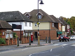
Frensham is a village in Surrey, England, next to the A287 road, 13 miles (20.9 km) WSW of Guildford, the county town. Frensham lies on the right bank of the River Wey, only navigable to canoes, shortly before its convergence with the north branch. Farnham is the nearest town, 3.5 miles (5.6 km) to the north.

Rowledge is a village in England on the Surrey–Hampshire border, centred south of the A31 and Farnham. Neighbouring villages include Wrecclesham, Spreakley and Frensham. To the south west of the village is the Alice Holt Forest; to the west is Birdworld. It is in the Waverley Ward of Farnham, Wrecclesham and Rowledge.
Churt is a village and civil parish in the borough of Waverley in Surrey, England, about 5.5 miles (8.9 km) south of the town of Farnham on the A287 road towards Hindhead. A clustered settlement is set in areas acting as its green buffers, which include the Devil's Jumps. The west of the village slopes down to the steep edge of Whitmore Vale, which is mostly in Headley, Hampshire; at the foot of this bank is a steeply cut brook which defines the Hampshire border. There are forests and heathland by and atop the Greensand Ridge, and the hamlet of Crosswater is in the north of the parish.
Esher Commons is a 360.1-hectare (890-acre) biological Site of Special Scientific Interest south-west of Esher in Surrey. It includes Esher Common, Fairmile Common, West End Common and Oxshott Heath. Esher Common and West End Common are Local Nature Reserves.

Horsell Common is a 355-hectare (880-acre) open space in Horsell, near Woking in Surrey. It is owned and managed by the Horsell Common Preservation Society. An area of 152 hectares is a biological Site of Special Scientific Interest and part of the Thames Basin Heaths Special Protection Area.
Thursley Common is a national nature reserve in Surrey, England, and has also been designated as a Ramsar wetland. It is also part of a Site of Special Scientific Interest called Thursley, Hankley and Frensham Commons.

Mother Ludlam's Cave, also known as Mother Ludlum's Cave or Mother Ludlum's Hole, is a small cave in the sandstone cliff of the Wey Valley at Moor Park, near Farnham, Surrey, in England. The cave is the subject of a number of local legends. A spring rising in the cave is recorded in the 13th century "Annals of Waverley Abbey" as "Ludewell"; other spellings through history include "Ludwell" and "Luddwelle". A monk named Symon is credited with identifying the spring as a suitable water supply for Waverley Abbey in 1218, after the original source had dried up. The brothers of the abbey dedicated the spring to St Mary, so it also became known as St Mary's Well. The cave has been naturally formed by the spring but may have been enlarged by the monks and was made into a grotto and further enhanced by addition of an ironstone arched entrance, possibly during the reign of Queen Victoria.

The River Wey is a main tributary of the River Thames in south east England. Its two branches, one of which rises near Alton in Hampshire and the other in West Sussex to the south of Haslemere, join at Tilford in Surrey. Once combined, the flow is eastwards then northwards via Godalming and Guildford to meet the Thames at Weybridge. Downstream the river forms the backdrop to Newark Priory and Brooklands. The Wey and Godalming Navigations were built in the 17th and 18th centuries, to create a navigable route from Godalming to the Thames.
Bourne Wood is an area of predominantly coniferous woodland just south of Farnham, Surrey, England; the area is often used as a film location. Near to another area also used as a film location, locally it was known as The Clumps, and was called this until Forestry England changed the name in the 1950s when fire breaks were introduced. Charles Darwin may have written about the area in Appendices of Natural Selection, describing the trees in clumps. A promontory (rise) above a large heathland clearing provides views over the surrounding woodland. Much of the wood was formerly heathland at the western end of the Greensand Ridge that was developed privately during the 20th century as commercial conifer plantations. This part of the wood has been purchased by the Royal Society for the Protection of Birds and is being restored mainly to heath, with retention of some woodland of wildlife significance, as Farnham Heath nature reserve. Their aim is to benefit scarce heathland species such as nightjar, woodlark, Dartford warbler and tree pipit as well as species such as sand lizard.
The Devil's Jumps are a series of three small hills near the village of Churt in the county of Surrey in southern England. In the 18th century, the hills were known as the Devil's Three Jumps. The Devil's Jumps are linked to a body of folklore relating to the surrounding area. The highest of the three Jumps, lying to the west, is High Jump with an elevation of 413 feet (126 m). Middle Devil's Jump has an elevation of 328 feet (100 m) and once supported an observatory built by 19th century British astronomer Richard Christopher Carrington. Stony Jump, the easternmost of the jumps, has an elevation of 394 feet (120 m).
Thursley, Hankley and Frensham Commons is a 1,878.5-hectare (4,642-acre) biological Site of Special Scientific Interest west of Godalming in Surrey. Thursley and Hankley Commons are Nature Conservation Review sites, Grade I. An area of 115.1 hectares is a local nature reserve called The Flashes and an area of 180 hectares is the Elstead Group of Commons, a nature reserve managed by the Surrey Wildlife Trust. Thursley Common is a national nature reserve. An area of 265.7 hectares is the Thursley & Ockley Bogs Ramsar site. The site is a Special Protection Area and part of the Thursley, Ash, Pirbright & Chobham Special Area of Conservation. Part of the land area designated as Thursley, Hankley and Frensham Commons SSSI is owned by the Ministry of Defence.
51°10′N00°47′W / 51.167°N 0.783°W
| Main rivers | 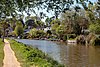 | |
|---|---|---|
| Canals and navigations | ||
| Ordinary watercourses | ||
| Lakes, ponds and wetlands |
| |
| Reservoirs | ||