Related Research Articles

A flood is an overflow of water that submerges land that is usually dry. In the sense of "flowing water", the word may also be applied to the inflow of the tide. Floods are of significant concern in agriculture, civil engineering and public health. Human changes to the environment often increase the intensity and frequency of flooding. Examples for human changes are land use changes such as deforestation and removal of wetlands, changes in waterway course or flood controls such as with levees. Global environmental issues also influence causes of floods, namely climate change which causes an intensification of the water cycle and sea level rise. For example, climate change makes extreme weather events more frequent and stronger. This leads to more intense floods and increased flood risk.
The Environment Agency (EA) is a non-departmental public body, established in 1996 and sponsored by the United Kingdom government's Department for Environment, Food and Rural Affairs, with responsibilities relating to the protection and enhancement of the environment in England.
Riparian water rights is a system for allocating water among those who possess land along its path. It has its origins in English common law. Riparian water rights exist in many jurisdictions with a common law heritage, such as Canada, Australia, New Zealand, and states in the eastern United States.
Hatfield Chase is a low-lying area in South Yorkshire and North Lincolnshire, England, which was often flooded. It was a royal hunting ground until Charles I appointed the Dutch engineer Cornelius Vermuyden to drain it in 1626. The work involved the re-routing of the Rivers Don, Idle, and Torne, and the construction of drainage channels. It was not wholly successful, but changed the whole nature of a wide swathe of land including the Isle of Axholme, and caused legal disputes for the rest of the century. The civil engineer John Smeaton looked at the problem of wintertime flooding in the 1760s, and some remedial work was carried out.
A flood risk assessment (FRA) is an assessment of the risk of flooding from all flooding mechanisms, the identification of flood mitigation measures and should provide advice on actions to be taken before and during a flood. The sources of water which produce floods include: groundwater, surface water, artificial water, sewers and drains, seawater.
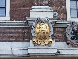
In the Netherlands, a water board, water council or water authority is a regional governing body solely charged with the management of surface water in the environment. Water boards are independent of administrative governing bodies like provinces and municipalities. In general, they are responsible for managing rivers and canals, issues with the flow of watercourses and drainage issues, water collection, flood and erosion prevention and provision of potable water. They manage polder systems, water levels, water barriers and locks, enforcements, water quality and sewage treatment in their respective regions. The concept of a coordinating "High Water Authority" (Hoogheemraadschap) originated in what now is the province of South Holland in the 12th century.

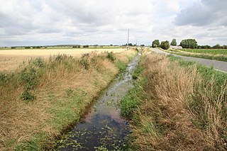
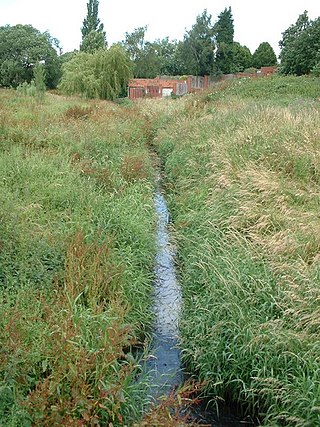
An internal drainage board (IDB) is a type of operating authority which is established in areas of special drainage need in England and Wales with permissive powers to undertake work to secure clean water drainage and water level management within drainage districts. The area of an IDB is not determined by county or metropolitan council boundaries, but by water catchment areas within a given region. IDBs are geographically concentrated in the Broads, Fens in East Anglia and Lincolnshire, Somerset Levels and Yorkshire.
The Association of Drainage Authorities (ADA) is a membership body for internal drainage boards and other stakeholders in water level management in the United Kingdom.
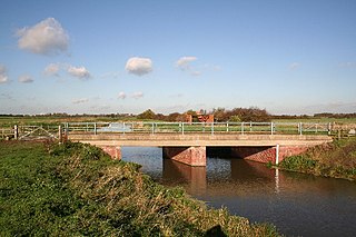
Main rivers are a statutory type of watercourse in England and Wales, usually larger streams and rivers, but also some smaller watercourses. A main river is designated by being marked as such on a main river map, and can include any structure or appliance for controlling or regulating the flow of water in, into or out of a main river. Every other open watercourse in England and Wales is determined by statute as an 'ordinary watercourse'.

The Middle Level Commissioners are a land drainage authority in eastern England. The body was formed in 1862, undertaking the main water level management function within the Middle Level following the breakup of the former Bedford Level Corporation.
Integrated urban water management (IUWM) in Buenos Aires is not unlike many large urban areas in Latin America where in past decades, more focus was placed on just a few sectors or perhaps only one sector. The water management philosophy in Buenos Aires has evolved to one that is integrating efforts in reducing water pollution, improving stormwater management, adding drainage infrastructure, and improving water supply and sanitation (WSS). Primary challenges in urban water management continue to be flood control and stormwater management as Buenos Aires is situated in the low-lying pampas region where heavy rain is expected all year long. Adding to the challenges, urbanization has outpaced planning and development in the various water sectors. Efforts have been made to control the major tributaries of Río de la Plata such as channelizing and building culverts into urban rivers, however, this has increased flooding as the natural meander and saturating ability of the rivers have been lost. Rapid urbanization and very large quantities of industrial discharge have also caused severe contamination of the water basins that Buenos Aires is built upon. The Matanza-Riachuelo river (MR), a tributary of the Río de la Plata, is a prime example and has become the most contaminated basin in Argentina.

The Water Resources Act 1991 (WRA) is an Act of the Parliament of the United Kingdom that regulates water resources, water quality and pollution, and flood defence. Part II of the Act provides the general structure for the management of water resources. Part III explains the standards expected for controlled waters; and what is considered to be water pollution. Part IV provides information on mitigation through flood defence.
The management of Jamaica's freshwater resources is primarily the domain and responsibility of the National Water Commission (NWC). The duties of providing service and water infrastructure maintenance for rural communities across Jamaica are shared with the Parish Councils. Where possible efficiencies have been identified, the NWC has outsourced various operations to the private sector.

Holderness Drain is the main feature of a land drainage scheme for the area of Holderness to the east of the River Hull in the East Riding of Yorkshire, England. Construction began in 1764, and several notable civil engineers were involved with the scheme over the years. Despite the high costs of the initial scheme, it was not particularly successful, because of the refusal of the ship owners of Hull to allow an outlet at Marfleet. They insisted that the water be discharged into the River Hull to keep the channel free of silt. Following a period of agricultural depression and the building of new docks in the early 1800s, an outlet at Marfleet was finally authorised in 1832. A high level system still fed upland water to the Hull, but the low level system discharged into the Humber, where levels were considerably lower. Following the success of steam pumping on the Beverley and Barmston Drain, the trustees looked at such a possibility for the Holderness Drain, but the development of the Alexandra Dock in the 1880s and then the King George V Dock in 1913 provided a solution, as the docks were topped up with water pumped from the drain, to lessen the ingress of silt-laden water.

Colin Reginald Thorne is Chair of Physical Geography at the University of Nottingham. A fluvial geomorphologist with an educational background in environmental sciences, civil engineering and physical geography; he has published 9 books and over 120 journal papers and book chapters.
The River Till is a river in the county of Lincolnshire in England and is ultimately a tributary of the River Witham. Its upper reaches drain the land east of Gainsborough. The middle section is embanked, as the water level is higher than that of the surrounding land, and pumping stations pump water from low level drainage ditches into the river. Its lower reaches from the hamlet of Odder near Saxilby into the city of Lincoln were canalised, possibly as early as Roman times, as part of the Foss Dyke.
The Flood and Water Management Act 2010 (c.29) is a UK Act of Parliament relating to the management of the risk concerning flooding and coastal erosion. The Act aims to reduce the flood risk associated with extreme weather, compounded by climate change. It created the role of Lead Local Flood Authority, which is the local government authority responsible for managing flood risk in the local government area. The Act gave new powers to local authorities, the Environment Agency, The Welsh Ministers and water companies.

The Upper Witham IDB is an English Internal Drainage Board responsible for land drainage and the management of flood risk for an area to the west of the Lincolnshire city of Lincoln, broadly following the valleys of the upper River Witham, the River Till and the course of the Fossdyke Navigation.
Holgate Beck is a small watercourse that flows north-eastwards through Holgate across the west side of the City of York, England. Primarily flowing through Holgate, from which it derives its name, the beck drains a large part of Askham Bog and Hob Moor, then running underneath the various lines near York railway station. It empties into the River Ouse at Water End, being one of five main tributaries for the River Ouse in York, and consequently added to the flooding in the river and immediate environs. To counter this, some flood diversionary schemes have been implemented near to Askham Bog and Hob Moor.

The Ea Beck, also spelled Eaubeck or Eau Beck, is a small river in South Yorkshire, England, that flows eastwards into the River Don at Thorpe-in-Balne. The Environment Agency lists the beck as starting at South Elmsall, but mapping lists the beck with several names along its course. The beck has twice flooded areas and villages that it passes through in the 21st century.
References
- 1 2 Explanation of terms on the Environment Agency's website Archived November 20, 2007, at the Wayback Machine
- ↑ DEFRA Flood risk management: information for flood risk management authorities, asset owners and local authorities Guidance and information on flood risk management and surface water management. Updated 7 August 2013. Retrieved 25 August 2013.
- ↑ Implementing the conclusions of the Flood and Coastal Defence Funding Review Final outturn report, 29 March 2004 DEFRA