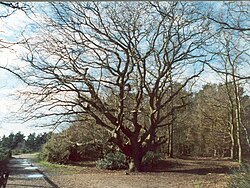
Esher Commons

Last updated

Esher Commons
Site of Special Scientific Interest
OxshottCom.JPG
Oxshott Heath on the escarpment
Location Surrey
Grid reference TQ 132 622 [1]
InterestBiological
Area360.1 hectares (890 acres) [1]
Notification 1986 [1]
Location map Magic Map

Esher Commons is a 360.1-hectare (890-acre) biological Site of Special Scientific Interest south-west of Esher in Surrey. [1] [2] It includes Esher Common, Fairmile Common, West End Common and Oxshott Heath. Esher Common [3] [4] and West End Common are Local Nature Reserves. [5] [6]

Contents

Geology and terrain

The geology of the Commons consists of the damp clay soils of the Claygate Beds and acidic soils of the Bagshot Beds and Plateau Gravels with peat on top. The terrain is lowland heath, predominantly covered by woodland, including both deciduous and coniferous trees, notably: oak; beech; silver birch; birch; and Scots Pine in various stages of maturity. There is also grassland, and areas of marsh, bog and open water which provide a rich variety of habitats to support many species of plant and animal life. The site is, however, exceptional in the diversity of its fungi. By 2017, about 3400 species had been recorded from this small area, including several new to science, making it the world's most intensively studied place for fungi. [7] Like Slapton Ley, Esher's Commons have been used as evidence to support the contention that fungi are, globally, many times more speciose than plants. [8]

The Common was not always wooded, and much of the area was formerly open heathland used as common grazing land. It had not been grazed for many years and much of the area is now secondary woodland, including conifer plantations from the 1950s. Grazing trials began on a small area of Esher Commons in 2015. In the first year 15 goats were introduced to a 2.5ha area of heath for a period of six months. [9] Esher Commons Site of Special Scientific Interest covers a large part of Arbrook, Esher, Oxshott, West End and Fairmile Commons and the Ledges. Arbrook Common is the easternmost, named after the Arbrook, at other points and sources known as the 'Rythe'. Otherwise much of the remainder of the commons is a subterranean aquifer. [10] [11] A programme to fell tracts of secondary woodland has led to various public protests. [12] In spite of the SSSI designation, the A3 Esher bypass was built through the middle of Esher Common in 1974. As compensation, approximately 90 acres (360,000 m2) of "exchange land" became part of the Commons. The Ledges were added to West End Common, and an area including Middle Pond became part of Esher Common.

Esher Common

Black Pond Black pond near Esher.jpeg
Black Pond

Esher Common is a [13] [14] It contains several ponds and lakes, the largest of which is Black Pond. This was once used as a water supply for the nearby Claremont Landscape Garden now owned and managed by the National Trust. The main piece of high ground is Round Hill, close to Copsem Lane.

There are parking facilities on the A307 (old Portsmouth Road) and the A244 (Copsem Lane).

West End Common

Water plants (Lysichiton americanus) growing near the River Mole EsherCom02.JPG
Water plants (Lysichiton americanus) growing near the River Mole

West End Common includes The Ledges, which is a bank of high ground alongside the River Mole.

The common shares the parking facilities on the A307, and can also be accessed from the direction of West End.

Related Research Articles

<span class="mw-page-title-main">Knettishall Heath</span>

Knettishall Heath is a 91.7-hectare (227-acre) biological Site of Special Scientific Interest west of Knettishall in Suffolk. A larger area of 176 hectares is the Knettishall Heath Nature Reserve, which is managed by the Suffolk Wildlife Trust.

<span class="mw-page-title-main">Oxshott Heath and Woods</span> Area in Oxshott, Surrey, England

Oxshott Heath and Woods is an area of woods and heathland in Oxshott, Surrey, England covering approximately 200 acres (81 ha), as an area of common land. It is owned by a local authority, however historic rights of access and gathering dead wood where necessary for individual fires are shared and exercised by landowners in the parish of Oxshott which has existed since the end of the 19th century, created from the east of the village of Stoke D'Abernon which in this area was extremely scantly populated until the construction of Oxshott railway station.

<span class="mw-page-title-main">Holt Heath, Dorset</span>

Holt Heath is a 4.88 square kilometres (1.88 sq mi) common situated four miles north-east of Wimborne Minster in east Dorset, southern England, close to the village of Holt. The reserve includes dry and wet heathland, bog and ancient woodland. The common has several nature conservation designations: national nature reserve, Special Protection Area, Special Area of Conservation and Site of Special Scientific Interest. It is owned by the National Trust and managed in association with Natural England. The heath is one of the few places where all six native British reptile species occur, and it also supports many other heathland animals, plants and birds. Rare heathland birds such as Eurasian Hobby, nightjar, Dartford warbler and woodlark have been recorded as breeding on the reserve.

<span class="mw-page-title-main">Chailey Common</span>

Chailey Common is a 169 hectare (417.4 acre) biological site of Special Scientific Interest in the East Sussex. It is close to the village of North Chailey to the west of Newick. The site was notified in 1985 under the Wildlife and Countryside Act 1981. It is also a Local Nature Reserve.

<span class="mw-page-title-main">Street Heath</span>

Street Heath is a 12.5 hectare biological Site of Special Scientific Interest 4 km west of Glastonbury in Somerset, notified in 1966. It next to the Glastonbury Canal and Ham Wall nature reserve. Street Heath has itself been designated as a Local Nature Reserve.

<span class="mw-page-title-main">Epsom Common</span> Local Nature Reserve in Surrey, England

Epsom Common is a 177.4-hectare (438-acre) Local Nature Reserve in Epsom, Surrey, England. It is owned and managed by Epsom and Ewell Borough Council. It is part of Epsom and Ashtead Commons, a Site of Special Scientific Interest.

<span class="mw-page-title-main">Ockham and Wisley Commons</span>

Ockham and Wisley Commons is a 266-hectare (660-acre) biological Site of Special Scientific Interest east of Woking in Surrey. It is also a Local Nature Reserve and part of the Thames Basin Heaths Special Protection Area. It is part of the slightly larger area of 297-hectare (730-acre) Wisley & Ockham Commons & Chatley Heath nature reserve, which is owned by Surrey County Council and managed by the Surrey Wildlife Trust.

<span class="mw-page-title-main">Greenham and Crookham Commons</span>

Greenham and Crookham Commons are two adjoining public park areas of 280.5-hectare (693-acre) common land designated as a biological Site of Special Scientific Interest (SSSI) in the civil parishes of Greenham and Thatcham, on the southern outskirts of Newbury in the English county of Berkshire.

<span class="mw-page-title-main">Poor's Allotment</span>

Poor's Allotment is a 28.57-hectare (70.6-acre) biological Site of Special Scientific Interest in Gloucestershire, notified in 1954. The site is listed in the 'Forest of Dean Local Plan Review' as a Key Wildlife Site (KWS).

<span class="mw-page-title-main">Heath Lake</span>

Heath Lake is a 6-hectare (15-acre) biological Site of Special Scientific Interest (SSSI) in Berkshire. The SSSI is part of the 22.3-hectare (55-acre) Heathlake Local Nature Reserve, which is owned and managed by Wokingham District Council.

<span class="mw-page-title-main">Leiston - Aldeburgh</span>

Leiston - Aldeburgh is a 534.8-hectare (1,322-acre) biological Site of Special Scientific Interest which stretches from Aldeburgh to Leiston in Suffolk. Part of it is The Haven, Aldeburgh Local Nature Reserve, and another area is the North Warren RSPB nature reserve. There is also a prehistoric bowl barrow on Aldringham Common, which is a Scheduled Monument. The site is in the Sandlings Special Protection Area under the European Union Directive on the Conservation of Wild Birds, and the Suffolk Coast and Heaths Area of Outstanding Natural Beauty.

<span class="mw-page-title-main">Thetford Heaths</span>

Thetford Heaths is a 270.6-hectare (669-acre) biological and geological Site of Special Scientific Interest in Suffolk. It is a Nature Conservation Review site, Grade I, and parts of it are a national nature reserve, and a Geological Conservation Review, It is part of the Breckland Special Area of Conservation, and Special Protection Area A large part of this dry heathland site is calcareous grassland, and some areas are grazed by sheep or rabbits. There are several nationally rare plants and an uncommon heathland bird, and many lichens and mosses.

<span class="mw-page-title-main">West End Common</span>

West End Common is a 70.3-hectare (174-acre) Local Nature Reserve on the north-western outskirts of Esher in Surrey. It is owned and managed by Elmbridge Borough Council. It is part of Esher Commons, which is a Site of Special Scientific Interest.

<span class="mw-page-title-main">Fairmile Bottom</span>

Fairmile Bottom is a 70.2-hectare (173-acre) biological Site of Special Scientific Interest north-west of Arundel in West Sussex. An area of 61.3 hectares is also a Local Nature Reserve.

<span class="mw-page-title-main">Broxhead and Kingsley Commons</span>

Broxhead and Kingsley Commons is a 105.1-hectare (260-acre) biological Site of Special Scientific Interest north of Lindford in Hampshire. It is part of Wealden Heaths Phase II Special Protection Area for the Conservation of Wild Birds and Broxhead Common is a 41.8-hectare (103-acre) Local Nature Reserve owned and managed by Hampshire County Council.

<span class="mw-page-title-main">Shortheath Common</span>

Shortheath Common is a 59.5-hectare (147-acre) biological Site of Special Scientific Interest east of Bordon in Hampshire. It is also a Local Nature Reserve and a Special Area of Conservation.

References

  1. 1 2 3 4 "Designated Sites View: Esher Commons". Sites of Special Scientific Interest. Natural England. Retrieved 7 November 2018.
  2. "Map of Esher Commons". Sites of Special Scientific Interest. Natural England. Retrieved 7 November 2018.
  3. "Esher Common". Local Nature Reserves. Natural England. Retrieved 7 November 2018.
  4. "Map of Esher Common". Local Nature Reserves. Natural England. Retrieved 7 November 2018.
  5. "West End Common". Local Nature Reserves. Natural England. Retrieved 7 November 2018.
  6. "Map of West End Common". Local Nature Reserves. Natural England. Retrieved 7 November 2018.
  7. "Esher Commons | Pan-species Listing". psl.brc.ac.uk. Retrieved 22 September 2023.
  8. "Fungal Diversity Revisited: 2.2 to 3.8 Million Species". journals.asm.org. doi:10.1128/microbiolspec.funk-0052-2016 . Retrieved 22 September 2023.
  9. "Goats to Maintain Heathland on Esher Common". Archived from the original on 26 February 2015. Retrieved 26 February 2015.
  10. "Esher Commons citation" (PDF). Sites of Special Scientific Interest. Natural England.
  11. "Map of Esher Commons". Sites of Special Scientific Interest. Natural England.
  12. "Esher News and Mail 7 August 2007". Archived from the original on 6 January 2009. Retrieved 29 January 2008.
  13. "Esher Common". Local Nature Reserves. Natural England.
  14. "Map of Esher Common". Local Nature Reserves. Natural England.

51°21′01″N0°22′08″W / 51.35040°N 0.36881°W / 51.35040; -0.36881