Sunbury Lock

Last updated • 4 min readFrom Wikipedia, The Free Encyclopedia

Sunbury Lock
Sunburylock.JPG
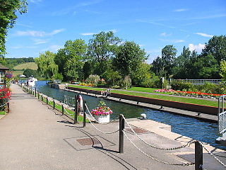
Sunbury lock with boats in the older hand-operated lock. The new lock is on the right
Sunbury Lock
51°24′18.5″N0°24′22″W / 51.405139°N 0.40611°W / 51.405139; -0.40611 (Sunbury Lock)
Waterway River Thames
County Surrey
Maintained by Environment Agency
OperationOld Manual
New Hydraulic
First built1812 (removed)
1856 (middle)
1927 (bankside)
LengthOld 47.15 m (154 ft 8 in)
New 62.78 m (206 ft 0 in) [1]
WidthOld 5.86 m (19 ft 3 in)
New 7.41 m (24 ft 4 in) [1]
FallBoth locks 1.87 m (6 ft 2 in) [1]
Above sea level27 feet (8 m)
Distance to
Teddington Lock
8 miles
Power is available out of hours
Sunbury Lock
the Walton, Weybridge
and Shepperton reach of the Thames
BSicon uSTR.svg
River Thames above Shepperton Lock
BSicon uISLAND.svg
Pharaoh's Island
BSicon uexSTR+l.svg
BSicon uSTRl.svg
BSicon uexABZgr.svg
BSicon uSTR+r.svg
Hamhaugh & Shepperton Lock Islands
BSicon uxWEIRg.svg
BSicon uxWEIRg.svg
BSicon uFGATEu.svg
weirs & Shepperton Lock
BSicon uexSTRq.svg
BSicon uexSTRl.svg
BSicon uexSTRq.svg
BSicon uexABZg+r.svg
BSicon uSTR.svg
BSicon uSTR+l.svg
BSicon uSTRq.svg
BSicon uFKRZ.svg
BSicon uFABZgr+r.svg
BSicon uFGATEd.svg
BSicon uexSTR+l.svg
BSicon uexSTRr.svg
BSicon uSTR.svg
Thames Lock
BSicon uWEIRr.svg
BSicon POINTERg@fq.svg
BSicon uexABZgr.svg
BSicon uSTR.svg
weir of River Wey
BSicon uWEIRr.svg
BSicon POINTERg@fq.svg
BSicon uexSTRr.svg
BSicon uSTR+l.svg
BSicon uSTRr.svg
weir of River Wey
BSicon uSTRr.svg
BSicon POINTERg@fq.svg
BSicon uSTR.svg
Wey and Godalming Navigations
BSicon uISLAND.svg
D'Oyly Carte Island
BSicon uABZgl.svg
BSicon uSTR+r.svg
BSicon ARCH.svg
Historic Church and Manor House, Shepperton
BSicon uSKRZ-Yu.svg
BSicon uSTR.svg
Desborough Island
BSicon uSKRZ-Yu.svg
BSicon uSTR.svg
BSicon uABZg+l.svg
BSicon uSTRr.svg
BSicon uSKRZ-Au.svg
A244 Walton Bridge
BSicon uddHSTRg.svg
BSicon uFKRZ.svg
BSicon uddHSTRg.svg
marinas
BSicon uSTR.svg
The "Walton Mile"
BSicon uWEIRr.svg
BSicon uexSTR+r.svg
Tumbling bay weir
BSicon uSTR.svg
BSicon uexABZg+l.svg
River Ash (distributary of Colne)
BSicon uWEIRr.svg
BSicon uexABZg+r.svg
Storm weir
BSicon uSTR.svg
BSicon uENDExa.svg
Wheatleys Ait north
BSicon uWEIRr.svg
BSicon ueABZg+r.svg
Sunbury main weir
BSicon uSTR.svg
BSicon uSTR2.svg
BSicon uSTRc3.svg
BSicon uSTR.svg
BSicon uSTRc1.svg
BSicon uSTR+4.svg
BSicon uSKRZ-Eu.svg
BSicon uSTR.svg
Sunbury Lock Ait
BSicon uSTR.svg
BSicon uddSTRl.svg
moorings
BSicon uABZgl.svg
BSicon uABZq+r.svg
BSicon uROLLERl.svg
boat rollers
BSicon uFGATEu.svg
BSicon uFGATEu.svg
BSicon uSTR.svg
Sunbury Lock
BSicon uABZg+l.svg
BSicon POINTERg@f.svg
BSicon uABZqr.svg
BSicon uSTRr.svg
manual Lock
BSicon uSTR.svg
River Thames above Molesey Lock
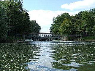
Looking towards Sunbury weir and lock from a skiff Tumbling Bay Weir and part of the Walton Mile of the River Thames in Surrey.jpg
Looking towards Sunbury weir and lock from a skiff

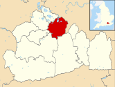
Sunbury Lock is a lock complex of the River Thames in England near Walton-on-Thames in north-west Surrey, the third lowest of forty four on the non-tidal reaches. The complex adjoins the right, southern bank about 12 mile (0.80 km) downstream of the Weir Hotel.

Contents

The complex is two locks, old and new, and a narrow concrete divide, which are downstream of the original lock built in 1812. The older, hand-operated, was originally built in 1856, seldom used. The newer was opened in 1927 by Lord Desborough. Rollers and a slope adjoins for the portage (hauling) of small boats. The lock adjoins Sunbury Lock Ait.

The lock has three associated weirs, upstream. The main weir is between Sunbury Lock Ait and Wheatley's Ait (north); the latter has two other weirs, one is a small part-time weir used in high flows.

History

The earliest major weir locally was built in 1789 specifically to divert water to create a deeper channel for navigation. [2] Other such weirs locally were in place since medieval times because of many shoals and flats in the Sunbury, in the period of Old London Bridge (1209-1831) which caused much silting downstream the river locally had minor tidal effects. [2] The first plan for a lock was in 1805 with an ambitious lock cut. [2] A modified scheme in 1809 resulted in the first lock, later removed, built close to the footbridge to Sunbury Lock Ait, where its lock house of the same year survives. [2] The associated long cut above the lock expanded a natural channel beside the island known as Church Island and the lock was opened in 1812. [2] The lock had become dilapidated by 1852 and the arrival of water companies planning major water extraction from the section of the river below the lock added an incentive for rebuilding it. [2] The lock was moved downstream and opened in 1856; a new lock house was built. [2] In 1927 a second lock was added at Sunbury, which was opened by Lord Desborough, then president of the Thames Conservancy.

Access to the lock

The lock is inaccessible by road and can be reached along the towpath from The Weir Hotel, Walton-on-Thames. The weir stream and Wheatley's Ait backwater, the Creek, is used for kayaking from the northern bank, between Shepperton and Sunbury-on-Thames.

Reach above the lock

Walton riverside from the river Waltonriver01.JPG
Walton riverside from the river

A 300 m cut upstream of Sunbury Lock Ait links to the Weir Hotel facing the Sunbury Weir which is followed by Wheatley's Ait hosting an Environment agency working area and riverside housing. More riverside housing, small parks and a marina feature on the Walton Mile and Cowey Sale reach below and above Walton Bridge, two pubs, and a marina. After Walton Bridge the river divides between the old course which meanders through Lower Halliford and Old Shepperton and the direct Desborough Cut alongside Desborough Island. Before Shepperton lock the waters rejoin where the Wey navigation the River Bourne and two mouths of the Wey join surrounding Hamhaugh Island. Immediately these, including the lock, the Shepperton to Weybridge Ferry.

Navigation transit markers are beside Desborough Cut to allow river users to check their speed.

The reach is home to six rowing clubs, a skiffing club, sailing and canoeing clubs. Walton and Weybridge Regatta, Walton Small Boats Head, Weybridge Silver Sculls, Weybridge Ladies Regatta and Walton Skiff Regatta are annual events.

Thames Path

The Thames Path continues along the Surrey bank until just before Shepperton Lock where the ferry goes across to the other side. To avoid the ferry calls for a long detour over Walton Bridge and via Shepperton.

Sports clubs on the reach

Kayaking

Sunbury Weir has the highest volume and fastest freestyle kayaking playspot on the River Thames. It is wide, surging and unfriendly to new or inexperienced paddlers. The eddyline is also very unstable and requires considerable effort to cross.

Access

Public car park on Fordbridge Road above on the left bank. From here across an informal football pitch with playground is a backwater, the Creek, which joins below the main weir.

Gates and weir pool level

The weir's gates are variously opened or closed as with the storm weir along the Creek.

Sunbury provides its optimal water at a certain pool level dependent on how many gates are open at the downstream weir (at Molesey), kayaking websites provide details.

Water levels

Literature and the Media

The lock is mentioned in Jerome K. Jerome's book Three Men in a Boat

"The river is sweetly pretty there just before you come to the gates, and the backwater is charming: but don't attempt to row up it"

See also

Next lock upstream River Thames Next lock downstream
Shepperton Lock
4.75 km (2.95 mi) [3]
Sunbury Lock
Grid reference: TQ109685
Molesey Lock
4.79 km (2.98 mi) [3]

Related Research Articles

<span class="mw-page-title-main">Locks and weirs on the River Thames</span>

The English River Thames is navigable from Cricklade or Lechlade to the sea, and this part of the river falls 71 meters (234 feet). There are 45 locks on the river, each with one or more adjacent weirs. These lock and weir combinations are used for controlling the flow of water down the river, most notably when there is a risk of flooding, and provide for navigation above the tideway.

<span class="mw-page-title-main">Teddington Lock</span> Series of locks on the River Thames in London

Teddington Lock is a complex of three locks and a weir on the River Thames between Ham and Teddington in the London Borough of Richmond upon Thames, England. Historically in Middlesex, it was first built in 1810.

<span class="mw-page-title-main">Thames Path</span> National Trail following the River Thames in England

The Thames Path is a National Trail following the River Thames from one of its sources near Kemble in Gloucestershire to the Woolwich foot tunnel, south east London. It is about 185 miles (298 km) long. A path was first proposed in 1948 but it only opened in 1996.

<span class="mw-page-title-main">Wheatley's Ait</span>

Wheatley's Ait or Wheatley Eyot is an ait (island) in the River Thames of approximately 8 hectares on the reach above Sunbury Lock, close to the northern side and in the post town Sunbury-on-Thames however in the Borough of Elmbridge in Surrey, England.
<span class="mw-page-title-main">Thames Conservancy</span> United Kingdom legislation

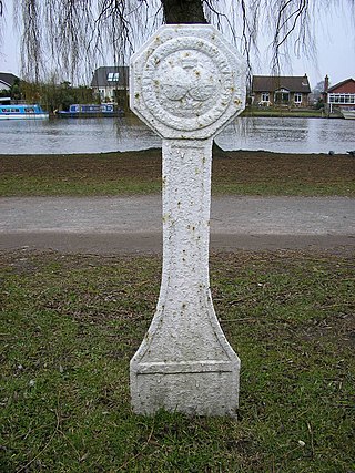
The Thames Conservancy was a body responsible for the management of that river in England. It was founded in 1857 to replace the jurisdiction of the City of London up to Staines. Nine years later it took on the whole river from Cricklade in Wiltshire to the sea at Yantlet Creek on the Isle of Grain. Its territory was reduced when the Tideway was transferred to the Port of London Authority in 1909.

<span class="mw-page-title-main">Hambleden Lock</span> Lock on the River Thames in Berkshire, England

Hambleden Lock is a lock with a long weir situated on the River Thames in England, about 2 miles downstream of Henley Bridge. The lock is on the Berkshire bank between Aston and Remenham. Built by the Thames Navigation Commission in 1773, the lock is named after the village of Hambleden, a mile (1.5 km) to the north.

<span class="mw-page-title-main">Kingston Rowing Club</span> English rowing club on the River Thames

Kingston Rowing Club (KRC) is a rowing club in England founded in 1858 and a member club of British Rowing.

<span class="mw-page-title-main">Iffley Lock</span> Lock on the River Thames in Oxfordshire, England

Iffley Lock is a lock on the River Thames in England near the village of Iffley, Oxfordshire. It is on the southern outskirts of Oxford. The original lock was built by the Oxford-Burcot Commission in 1631 and the Thames Navigation Commission replaced this in 1793. The lock has a set of rollers to allow punts and rowing boats to be moved between the water levels.

<span class="mw-page-title-main">Shepperton Lock</span> Lock on the River Thames in Surrey, England

Shepperton Lock is a lock on the River Thames, in England by the left bank at Shepperton, Surrey. It is across the river from Weybridge which is nearby linked by a passenger ferry.

<span class="mw-page-title-main">Sunbury Amateur Regatta</span>

The Sunbury Amateur Regatta is a regatta on the River Thames at Sunbury-on-Thames, Surrey, England with a rare visitors' boats lights display and fireworks event. It is for mainly traditional wooden types of boats with a few events for small sculling boats since its instigation in 1877 taking place by convention on a Saturday in early to mid August. The Edith Topsfield Junior Regatta takes place the following day.

<span class="mw-page-title-main">Molesey Lock</span> Lock on the River Thames in Surrey, England

Molesey Lock is a lock on the River Thames in England at East Molesey, Surrey on the right bank.

<span class="mw-page-title-main">Weybridge Rowing Club</span>

Weybridge Rowing Club, founded in 1881, is a rowing club by the Thames in England, on the Surrey bank. The club organises head races, notably the Weybridge Silver Sculls which has had Olympian winners and co-organises a May/June regatta. It consists of a wide range of members: juniors, novices, seniors, masters (veterans) – these include many past and present champions.

<span class="mw-page-title-main">Wey and Godalming Navigations</span> Waterways in Surrey, England

The River Wey Navigation and Godalming Navigation together provide a 20-mile (32 km) continuous navigable route from the River Thames near Weybridge via Guildford to Godalming. Both waterways are in Surrey and are owned by the National Trust. The River Wey Navigation connects to the Basingstoke Canal at West Byfleet, and the Godalming Navigation to the Wey and Arun Canal near Shalford. The navigations consist of both man-made canal cuts and adapted parts of the River Wey.

<span class="mw-page-title-main">Desborough Island</span> Island in the River Thames

Desborough Island is a 112-acre (0.45 km2) manmade island in the River Thames on the reach above Sunbury Lock in Surrey, England. It was formed in the 1930s by the digging of a channel – the Desborough Cut – by the Thames Conservancy as a meander cutoff of narrow width on the right bank. The island and cut are named after Lord Desborough, a chairman of the Thames Conservancy.

<span class="mw-page-title-main">Bell Weir Lock</span> Lock on the River Thames in England

Bell Weir Lock is a lock on the River Thames in England by the right bank, Runnymede which is a water meadow associated with Egham of importance for the constitutional Magna Carta. It is upstream of the terrace of a hotel and the a bridge designed by Edwin Lutyens who designed an ornamental park gate house along the reach. The bridge has been widened and carries the M25 and A30 road across the river in a single span. The lock was first built by the Thames Navigation Commission in 1817; it has one weir which is upstream. The lock is the eighth lowest of forty-five on the river and is named after the founder of the forerunner of the adjoining hotel who took charge of the lock and weir on its construction.

<span class="mw-page-title-main">Sunbury Lock Ait</span> Island in the River Thames

Sunbury Lock Ait is the ait (island) in the River Thames in England adjacent to Sunbury Lock between Walton-on-Thames, and Sunbury-on-Thames, Surrey. It is unpopulated, but accessible by a footbridge over the lock cut from a wide section of the Thames Path towpath on the southern bank as well as walkways on the lock gates. Thirdly, a walkway links to Wheatley's Ait upstream, across the weir, but this is closed to the public. The quite long, thin island is inaccessible from Sunbury-on-Thames where it faces a long section of public riverbank, a few private conservation area Victorian terraces with moorings and two pubs also with moorings.
<span class="mw-page-title-main">Hamhaugh Island</span>

Hamhaugh Island is an island, historically known simply as Stadbury, in the River Thames in England south of Shepperton Lock, in Shepperton, Surrey.

<span class="mw-page-title-main">Thames Valley Skiff Club</span>

Thames Valley Skiff Club is an English skiff and punting club, which was founded in 1923. It is based on the River Thames in England, on the Surrey bank between Sunbury Lock and Walton on Thames.

<span class="mw-page-title-main">Walton Rowing Club</span>

Walton Rowing Club is an amateur rowing club, on the River Thames in England. Its large, modern, combined club and boat house is on the Surrey bank of the Thames, facing the Walton Mile straight, at Walton-on-Thames about 400 metres (1,300 ft) above Sunbury Lock cut. The club organises several rowing events, and members have competed at international level.

<span class="mw-page-title-main">Desborough Cut</span> Channel in Surrey, England

The Desborough Cut is an artificial channel in the River Thames above Sunbury Lock near Walton on Thames in England. It was completed in 1935, to improve flow and ease navigation on the river.

References

  1. 1 2 3 "Environment Agency Dimensions of locks on the River Thames". web page. Environmental Agency. 8 November 2012. Retrieved 18 November 2012. Dimensions given in metres
  2. 1 2 3 4 5 6 7 Fred. S. Thacker The Thames Highway: Volume II Locks and Weirs 1920 - republished 1968 David & Charles
  3. 1 2 "Environment Agency Distances between locks on the River Thames". web page. Environmental Agency. 19 November 2012. Retrieved 22 November 2012. Distances given in km.