Downside, Surrey

Last updated • 5 min readFrom Wikipedia, The Free Encyclopedia

Downside
Village
The Cricketers - geograph.org.uk - 791052.jpg
The Cricketers' Inn, Downside
Surrey UK location map.svg
Red pog.svg
Downside
Location within Surrey
Population6,564 (2011 Census. Cobham and Downside Ward) [1]
OS grid reference TQ109581
District
Shire county
Region
Country England
Sovereign state United Kingdom
Post town Cobham
Postcode district KT11
Dialling code 01932
Police Surrey
Fire Surrey
Ambulance South East Coast
UK Parliament
List of places
UK
England
Surrey
51°18′42″N0°24′34″W / 51.311658°N 0.409531°W / 51.311658; -0.409531

Downside is a small village in the English county of Surrey, in the local government district of Elmbridge, centred on Downside Common which is 18 miles (29 km) southwest of London and 8.4 miles (13.5 km) northeast of Guildford. Most of its buildings form a cluster. It has an inn, Downside Sports and Social Club, regular village hall events and an annual sports day. It is in the Cobham and Downside ward of Elmbridge Borough Council.

Contents

History

Toponymy

The village was a tything (an ancient administrative division represented by an assembly of households within an area comprising ten hides). Downe Place was the home of the Downe (or Adowne) family for many generations, from at least the 12th century. H.E. Malden [2] followed E.W. Brayley [3] in deriving the locality name "Downside" from the family, but T.E.C. Walker more credibly derived the family's name from the location, referring to the hill or down near the river on that side of Cobham. [4] That house was later also known as "Downe Hall".

Early history

In 1331 the prior and convent of Newark by Guildford acquired 100 acres (40 ha) from John Prudhomme held of Henry de Somerbury, who held of Henry atte Downe, who held of Chertsey Abbey. The historian David Taylor shows that the old Downe Place probably stood near Downside Farm, and not on the site of the Cobham Park mansion. [5]

Much of the village green was part of a common open to those with villager status of the Downeside Tything as opposed to the two others: Street Cobham and Church Cobham. As to the manors that were in private hands in the Middle Ages, see the parish of Cobham, as Downside's chapel was built on land in Cobham ecclesiastical parish.

Neither of the settlements is a civil parish and the church became tied with that of Ockham at an unknown date after its 19th-century construction.

Downside Village was designated as a Conservation Area in 1979, focussed around its developed, village green area. [6]

Geography

A rural community, Downside (and the adjacent hamlet of Hatchford) is situated in open countryside between Cobham to the north and East Horsley to the south, Stoke D'Abernon to the east and two similar size settlements across the Surrey Wildlife Trust expanse of Wisley Heath and Ockham Common: Ockham and Wisley to the west. London is 18 miles (29 km) northeast, Guildford is 8.4 miles (13.5 km) southwest. Local administrative centre of Elmbridge, Esher /ˈʃər/ , is 4.4 miles (7.1 km) NNE. [7]

This elevated community is part of the Green Belt. Immediately to the south of the village is the M25 motorway, where construction of a motorway service station began, despite determined local opposition, in 2011. To the north is Cobham Park, a large country house that has been converted to apartments.

The village water pump DownsideVillagePump.JPG
The village water pump

Downside has a large village green, on the northern edge of which is the Cricketers' Inn, dating at its core to the 17th century and a Grade II listed building. [8] [9] Immediately off the green in the south east corner is a listed hand-operated water pump. [10]

Elevations, Soils and Geology

Elevations of the central part of Downside, on all sides of the Common vary from 36 metres (118 ft) AOD in the southwest to 27 metres (89 ft) Above Ordnance Datum in the northeast, while the common itself ranges between 29-33m AOD. Immediately north of this the River Mole begins to cut a valley and in Cobham, most of which, excluding Fairmile is at 18-22m AOD. [7] [11]

Not within the narrow belt of raised soils of the north Surrey belt of acidic, sandy raised heathland of the Bagshot Formation, the soil stretching from Cobham and Downside as far as Effingham and for a more considerable distance east and southwest is "slowly permeable loamy/clayey slightly acid but base-rich soil", which gives rise to flora of trees, grasses and crops or which can be cultivated easily. [12] As the later sandy soil mentioned above and certainly further chalk overlayers have been washed away, whereas sand may have been scant, hence why it appears further north; the geology of Downside is Cretaceous: i.e. Hastings Beds, Weald Clay, then pleistocene Folkestone and then covered by a considerable remaining layer of Claygate Beds, Gault Clay mixed in with some eroded limestone from the north downs in the soil to the south. [13]

Demography

In 2001, the central output area of Downside contained 306 residents in 126 households, of which 11.4% were aged over 65; 6.0% of the population were in full-time further education; 70.6% of those of working age were economically active whereas 0.0% were unemployed, 11.7% [14]

As to ethnicity, 89.5% of the population identified themselves as being White British ethnicity, 2.0% as of White Irish ethnicity and 8.5% as White Other of the categories available. [14]

In terms of religion, 76.0%% of the population responded as being Christian, 1.3% as Jewish, 16.4% as atheist and 6.2% declined to answer. [14]

Downside's economy is predominantly a service sector economy reflected by the lowest versus the upper end of the official categorisation table of occupation given, compiled from the 2001 census:

CategoryNumber of adults in category in 2001Percentage of those aged 16–74
Elementary occupations2414.9%
Managers and Senior Officials4427.4%
Professional Occupations159.3%
Skilled Trades Occupations2314.3%
Administrative and Secretarial Occupations169.9%
Associate Professional and Technical Occupations63.7%

[14]

Religion

St Michael's Chapel by the village green serves the village's Church of England community and those seeking its help in the Diocese of Guildford, at the end of the only fully developed street. [15]

Culture and Community

Downside Sports & Social Club operate with a mixture of cricket, bowls, football and entertainment. Downside Village Hall hosts voluntary-run classes and meetings for local groups and organisations.

Downside village green, historically and legally Downside Common, is the setting for the Downside & Hatchford Sports Day, held annually on August Bank Holiday Monday.

Education

St. Matthew's Church of England Infant School serves the wider area of Downside including Cobham. [16]

Related Research Articles

<span class="mw-page-title-main">Wisley</span> Village and civil parish in England

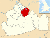
Wisley is a village and civil parish in Surrey, England between Cobham and Woking, in the Borough of Guildford. It is the home of the Royal Horticultural Society's Wisley Garden. The River Wey runs through the village and Ockham and Wisley Commons form a large proportion of the parish on a high acid heathland, which is a rare soil type providing for its own types of habitat. It has a standard weather monitoring station, which has recorded some national record high temperatures.

<span class="mw-page-title-main">Cobham, Surrey</span> Village in the Borough of Elmbridge in Surrey, England

Cobham is a village in the Borough of Elmbridge in Surrey, England, centred 17 miles (27 km) south-west of London and 10 miles (16 km) northeast of Guildford on the River Mole. It has a commercial/services High Street, a significant number of primary and private schools and the Painshill landscape park.

<span class="mw-page-title-main">Ockham, Surrey</span> Village in England

Ockham is a rural and semi-rural village in the borough of Guildford in Surrey, England. The village starts immediately east of the A3 but the lands extend to the River Wey in the west where it has a large mill-house. Ockham is between Cobham and East Horsley.

<span class="mw-page-title-main">Borough of Elmbridge</span> Local government district in Surrey, England

Elmbridge is a local government district with borough status in Surrey, England. Its council is based in Esher, and other notable towns and villages include Cobham, Walton-on-Thames, Weybridge and Molesey. The borough lies just outside the administrative boundary of Greater London, but is almost entirely within the M25 motorway which encircles London. Many of the borough's urban areas form part of the wider Greater London Built-up Area.

<span class="mw-page-title-main">Shackleford</span> Village and civil parish in England

Shackleford is a village and civil parish in the Borough of Guildford, Surrey, England centred to the west of the A3 between Guildford and Petersfield 32 miles (51 km) southwest of London and 5.2 miles (8.4 km) southwest of Guildford. Shackleford includes the localities of Eashing, Hurtmore, Norney and Gatwick.

<span class="mw-page-title-main">Thames Ditton</span> Village in Surrey, England

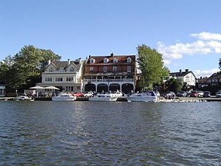
Thames Ditton is a suburban village on the River Thames, in the Elmbridge borough of Surrey, England. Apart from a large inhabited island in the river, it lies on the southern bank, centred 12.2 miles (19.6 km) southwest of Charing Cross in central London. Thames Ditton is just outside Greater London but within the Greater London Urban Area as defined by the Office for National Statistics. Its clustered village centre and shopping area on a winding High Street is surrounded by housing, schools and sports areas. Its riverside faces the Thames Path and Hampton Court Palace Gardens and golf course in the London Borough of Richmond upon Thames. Its most commercial area is spread throughout its conservation area and contains restaurants, cafés, shops and businesses.

<span class="mw-page-title-main">Ripley, Surrey</span> Village in Surrey, England

Ripley is a village and civil parish in Surrey, England. It is centred 6.2 miles (10.0 km) southeast of Woking, 6.8 miles (10.9 km) northeast of Guildford and 22.5 miles (36.2 km) southwest of London. Neighbouring villages Send and Send Marsh to the South-West and Ockham to the East have fewer shopping facilities.

<span class="mw-page-title-main">Stoke d'Abernon</span> Village in England

Stoke d'Abernon is a village and former civil parish in the Elmbridge district, in Surrey, England. It is on the right bank of the River Mole contiguously south of Cobham, a larger settlement which is a post town and is east-southeast of Oxshott a large village founded in the 19th century from the higher, sandy forested part of its formerly expansive area. It shares a railway station with Cobham and is inside the M25 motorway. Cobham Training Centre, the training ground of Chelsea F.C., is within its traditional boundaries.

<span class="mw-page-title-main">Claygate</span> Village and parish in Surrey, England

Claygate is an affluent suburban village in Surrey, England, 14 miles southwest of central London. It is the only civil parish in the borough of Elmbridge. Adjoining Esher and Hinchley Wood to the west and north respectively, and bordered by green belt land to the south and east, Claygate lies within the Greater London Built-up Area.

<span class="mw-page-title-main">Wonersh</span> Village and civil parish in England

Wonersh is a village and civil parish in the Waverley district of Surrey, England and Surrey Hills Area of Outstanding Natural Beauty. Wonersh contains three Conservation Areas and spans an area three to six miles SSE of Guildford.

<span class="mw-page-title-main">Farleigh, Surrey</span> Human settlement in England

Farleigh is a village and former civil parish, now in the parish of Chelsham and Farleigh in the Tandridge district of Surrey, England. It is located in the North Downs AONB and the Metropolitan Green Belt, 4.5 miles (7.2 km) south east of Croydon, 13.4 miles (21.6 km) south of London and 25 miles (40 km) WNE of Surrey's county town, Guildford. In 1961 the parish had a population of 1285.

<span class="mw-page-title-main">Peaslake</span> Village in Surrey, England

Peaslake, Hoe, and Colman's Hill are in the centre of the Surrey Hills National Landscape and mid-west of the Greensand Ridge about 5 miles (8.0 km) ESE of Guildford. Surrounded by denser pine and other coniferous forest-clad hills, the three conjoined settlements have a small core in Peaslake itself with the amenities of a village, but are otherwise lightly scattered settlements at a higher elevation than the centre of Shere, the civil parish.

<span class="mw-page-title-main">West End, Surrey</span> Village in Surrey, England

West End is a village and civil parish in Surrey Heath, Surrey, England, approximately 25 miles (40 km) southwest of central London. It is midway between the towns of Camberley and Woking, 4 mi (6.4 km) to the west and east respectively. The River Bourne rises from its sources to the immediate west to run through the village. Until the mid 20th century, the West End consisted of a collection of smallholdings surrounded by a substantial area of common land

<span class="mw-page-title-main">Cobham Park</span>

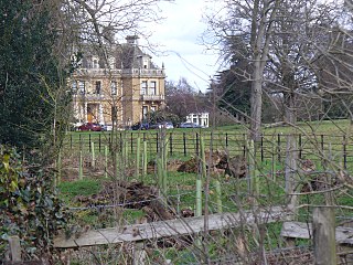
Cobham Park is a former mansion and country estate in Cobham, Surrey, England. The main house was converted to apartments in the early 2000s, but the majority of the surrounding former parkland remains undeveloped. At its height in the 19th century, the estate included the majority of the neighbouring settlement of dowside Downside.

<span class="mw-page-title-main">Chatley Heath</span>

Chatley Heath is part of a 336 hectares (1.3 sq mi) reserve including Wisley Common, Ockham and parts of Hatchford. It is an area consisting of mixed habitats including heathland, ancient woodland and conifer woodland. On the top of Chatley Heath is a tower built as part of the Royal Navy Semaphore line.

<span class="mw-page-title-main">Wisley Airfield</span> Airport in Surrey, England

Wisley Airfield is a former wartime airfield located in the Parish of Ockham near Wisley in Surrey, England. Originally a grass airstrip, used to test aircraft built at Weybridge by Vickers the runway was converted to tarmac in 1952. The airfield continued in use for test aircraft when Vickers aviation activities were subsumed into British Aviation Corporation (BAC). Flying ceased in 1973 because the runway was too short for large aircraft and was too close to Heathrow Airport. All the structures on the site were removed, except for the runway, and the land was sold back to its principal former owner in 1980 for agricultural use.

<span class="mw-page-title-main">Ockham Park</span> Country house in Ockham, Surrey

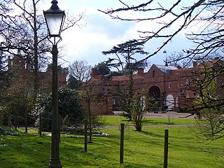
Ockham Park is a seventeenth-century English country house in Ockham, Surrey.

<span class="mw-page-title-main">Hatchford</span> Human settlement in England

Hatchford is a hamlet in the English county of Surrey outside the town of Cobham ; it traditionally includes the contiguous hamlet of Pointers Green.

References

  1. "Ward population 2011". Neighbourhood Statistics. Office for National Statistics. Archived from the original on 21 October 2016. Retrieved 6 October 2016.
  2. 'Parishes: Cobham - Manor of Downe', in H.E. Malden (ed.), A History of the County of Surrey, Vol. 3 (V.C.H., London 1911), at p. 444, col. b (British History Online, accessed 18 January 2023).
  3. E.W. Brayley, with J. Britton and E.W. Brayley jun., A Topographical History of Surrey, 5 vols (London 1841-1848), II, pp. 410-11 (Google).
  4. "Manor of Downe", in T.E.C. Walker, 'Cobham: Manorial History', Surrey Archaeological Collections 58 (1961), pp. 47-78, at pp. 52-56 (Internet Archive).
  5. D. Taylor, 'Cobham Park: Recent discoveries relating to its early history', Surrey Archaeological Society Bulletin 366 (April 2003) pp. 2-5 (Society's pdf).
  6. "Cobham Conservation Areas". cobhamheritage.org.uk. Archived from the original on 6 January 2009. Retrieved 12 November 2011.
  7. 1 2 Grid reference Finder measurement tools
  8. Cricketers' Inn Historic England. "Details from listed building database (1294555)". National Heritage List for England . Retrieved 29 October 2013.
  9. "Cricketers' Inn photographs and informal architectural summary". britishlistedbuildings. Retrieved 12 November 2011.
  10. Historic England. "Details from listed building database (1030210)". National Heritage List for England . Retrieved 29 October 2013.
  11. Map created by Ordnance Survey, courtesy of English Heritage Archived 24 April 2012 at the Wayback Machine
  12. Cranfield University National Soil Resources Institute
  13. Natural England – Geodiversity Archived 2 October 2013 at the Wayback Machine
  14. 1 2 3 4 "2001 Census for majority of Downside: E00154561 (Output Area)". Archived from the original on 11 February 2003. Retrieved 7 November 2012.
  15. Church of England Website – St Michael's Chapel, Downside
  16. St. Matthew's Church of England Infant School Grade II listing Historic England. "Details from listed building database (1030052)". National Heritage List for England . Retrieved 7 November 2012.