Weybridge Heath

Last updated
Scrub clearance area WeybridgeHeathScrubClearance.JPG
Scrub clearance area

Weybridge Heath is a part of Weybridge common, in South East England.

The Heath comprises 47 acres (190,200 square metres) of lowland heathland that runs from the deep cutting of the South West Main Line railway eastwards to Cobbetts Hill. To the west of the railway line, much of the original heathland is now occupied by Heathside School and Brooklands College.

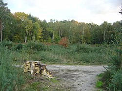
During the 1970s and 1980s the heathland fell into a poor state of repair because the surrounding brush was ill-maintained and coppicing, which is essential for the maintenance of small heaths, had ceased. Gradually, the area became more and more overgrown with newly grown brush composed of the saplings of deciduous trees, and became to resemble more of a young wood.

Because the area used to contain many species of ants, rare birds and insectivorous plants, Surrey County Council embarked in 1989 upon a project to renew the heathland and encourage the return of the area to its original habitat type. The project consisted of the removal of many taller trees from a central portion of the site, and the clearing of brush from this area. The council hoped that the area would be returned to something approaching its former glory within a decade.

Evidence of the re-growth of heathland is not great as of 2003, and some local residents are sceptical about the apparent defacement of the area, dubbing the cleared area "the bomb site".

It was on the original heath in this location that British myrmecologist Horace Donisthorpe collected many of the ants from which he produced so many observations and deductions.

Related Research Articles

Weybridge Human settlement in England

Weybridge is a town by the River Wey in the Elmbridge district of Surrey. It is bounded to the north by the River Thames at the mouth of the Wey, from which it gets its name. It is an outlying suburban town within the Greater London Urban Area, situated seven miles northeast of Woking and 16 miles southwest of central London. House prices are well above the national average: as of 2008, six of the ten most expensive streets in South East England were in Weybridge. and is the 2nd most expensive place to buy property outside of London as of 2021.

Chobham Common Location near Chobham, Surrey, of a British tank research centre

Chobham Common is a 655.7-hectare (1,620-acre) biological Site of Special Scientific Interest north of Chobham in Surrey. It is a Nature Conservation Review site, Grade I and a national nature reserve. It is part of the Thames Basin Heaths Special Protection Area and the Thursley, Ash, Pirbright and Chobham Special Area of Conservation. It contains three scheduled monuments. Most of the site is managed by the Surrey Wildlife Trust as the Chobham Common nature reserve, but the SSSI also includes a small private reserve managed by the Trust, Gracious Pond.

South Staffordshire Non-metropolitan district in England

South Staffordshire is a local government district in Staffordshire, England. The district lies to the north and west of the West Midlands county, bordering Shropshire to the west and Worcestershire to the south. It contains notable settlements such as Codsall, Cheslyn Hay, Great Wyrley, Penkridge, Brewood, Coven, Essington, Huntington, Weston-under-Lizard, Bilbrook, Wombourne, Himley, Perton and Featherstone. Codsall is the main adminstrative centre of South Staffordshire District. Many of the villages form both commuter and residential areas for the nearby towns of Cannock, Stafford and Telford. As well as the wider West Midlands County.

Surrey Heath Place in England

Surrey Heath is a local government district with borough status in Surrey, England. Its council is based in Camberley. Much of the area is within the Metropolitan Green Belt.

Borough of Elmbridge Non-metropolitan district in England

Elmbridge is a local government district with borough status in Surrey, England. Its principal towns are Esher, Cobham, Walton-on-Thames, Weybridge and Molesey. It directly borders the London Borough of Richmond upon Thames and the London Royal Borough of Kingston upon Thames. Areas of the borough form a continuation of the Greater London built-up area, formerly falling into the Metropolitan Police District.

Heath Shrubland habitat

A heath is a shrubland habitat found mainly on free-draining infertile, acidic soils and characterised by open, low-growing woody vegetation. Moorland is generally related to high-ground heaths with—especially in Great Britain—a cooler and damper climate.

Witley Common

Witley Common is an area of woodland and heath, close to Witley, Surrey, in the United Kingdom. It is part of a much larger Site of Special Scientific Interest.

Oxshott Heath and Woods

Oxshott Heath and Woods is an area of woods and heathland in Oxshott, Surrey, England covering approximately 200 acres (81 ha), as an area of common land. It is owned by a local authority, however historic rights of access and gathering dead wood where necessary for individual fires are shared and exercised by landowners in the parish of Oxshott which has existed since the end of the 19th century, created from the east of the village of Stoke D'Abernon which in this area was extremely scantly populated until the construction of Oxshott railway station.

Lightwater Human settlement in England

Lightwater is a village in the Surrey Heath district of Surrey, England, about 27 miles (43 km) southwest of central London. Immediately surrounding towns and villages include Bagshot, Deepcut, Windlesham, Camberley, and West End, Woking. It is bounded to the north-west by the M3 motorway and to the north-east by the "Lightwater Bypass" (A322). To the south-east it is bounded by the "Red Road" (B311), while to the south-west there are vehicle-testing tracks owned by the Ministry of Defence.

Broadmoor to Bagshot Woods and Heaths

Broadmoor to Bagshot Woods and Heaths is a 1,696.3-hectare (4,192-acre) biological Site of Special Scientific Interest (SSSI) in Berkshire and Surrey that extend from a minority of the parish of Crowthorne including around Broadmoor Hospital in the west to Bagshot south-east, Bracknell north-east, and Sandhurst, south. It is part of the Thames Basin Heaths Special Protection Area. Two nature reserves which are managed by the Surrey Wildlife Trust are in the SSSI, Barossa nature reserve and Poors Allotment. Broadmoor Bottom, which is part of Wildmoor Heath, also falls within the SSSI; this reserve is managed by the Berkshire, Buckinghamshire and Oxfordshire Wildlife Trust.

Frensham Common

Frensham Common is a large Site of Special Scientific Interest (SSSI) heathland of 922 acres (3.73 km2) which includes two lakes; it is owned by the National Trust.

Esher Commons Several large wooded areas to the south-west of Esher

Esher Commons is a 360.1-hectare (890-acre) biological Site of Special Scientific Interest south-west of Esher in Surrey. It includes Esher Common, Fairmile Common, West End Common and Oxshott Heath. Esher Common and West End Common are Local Nature Reserves.

Horsell Common

Horsell Common is a 355-hectare (880-acre) open space in Horsell, near Woking in Surrey. It is owned and managed by the Horsell Common Preservation Society. An area of 152 hectares is a biological Site of Special Scientific Interest and part of the Thames Basin Heaths Special Protection Area.

Thursley Common is a national nature reserve in Surrey, England, and has also been designated as a Ramsar wetland. It is also part of a Site of Special Scientific Interest called Thursley, Hankley and Frensham Commons.

Lowfield Heath Human settlement in England

Lowfield Heath is a former village within the boundaries of the Borough of Crawley, West Sussex, England. Situated on the main London to Brighton road approximately 27 miles (43 km) south of London and 2 miles (3.2 km) north of Crawley, it was gradually rendered uninhabitable by the expansion of London Gatwick Airport immediately to the north.

Bourne Wood Area of predominantly coniferous woodland just south of Farnham, Surrey, England

Bourne Wood is an area of predominantly coniferous woodland just south of Farnham, Surrey, England and a film location, under 10 minutes from the famous film location of Hankley Common in Elstead. Locally it was known as the Clumps, and was called this until the forestry commission changed the name in the 1950s when fire breaks were introduced, Charles Darwin may have written about the area in Appendices of Natural Selection-describing the trees in clumps. A promontory (rise) above a large heathland clearing provides views over the surrounding woodland. Much of the wood was formerly heathland at the western end of the Greensand Ridge that was developed privately during the 20th century as commercial conifer plantations. This part of the wood has been purchased by the Royal Society for the Protection of Birds and is being restored mainly to heath, with retention of some woodland of wildlife significance, as Farnham Heath nature reserve. Their aim is to benefit scarce heathland species such as nightjar, woodlark, Dartford warbler and tree pipit as well as species such as sand lizard.

Naphill Common

Naphhill Common is a 71.1 hectare Site of Special Scientific Interest in Naphill in Buckinghamshire. It is in of the Chilterns Area of Outstanding Natural Beauty, and it is listed in A Nature Conservation Review. It is common land, with commoners' rights to estovers, grazing and firebote.

Gracious Pond

Gracious Pond is a 14-hectare (35-acre) nature reserve in Chobham in Surrey. It is managed by the Surrey Wildlife Trust. It is part of Chobham Common Site of Special Scientific Interest.

References

Coordinates: 51°21′44″N0°27′16″W / 51.36217°N 0.45446°W / 51.36217; -0.45446