
Hamhaugh Island is an island, historically known simply as Stadbury, in the River Thames in England south of Shepperton Lock, in Shepperton, Surrey.
Hamhaugh Island is an island, historically known simply as Stadbury, in the River Thames in England south of Shepperton Lock, in Shepperton, Surrey.
The island is at the southernmost point of the River Thames. The garden-lined southern horseshoe curve of the island is mapped as Hamhaugh Point, and being its only tapered side becomes the narrowest width. Otherwise Hamhaugh is almost rectangular: 690 metres (2,260 ft) long and 100–120 metres (330–390 ft) wide. It is 800 metres (2,600 ft) from the parish churches of Shepperton and Weybridge respectively, however Shepperton High Street is a further 400 metres (1,300 ft) north of this whereas Weybridge High Street runs next to its parish church, which means the whole area is closer to Weybridge's urban resources.
The town is accessible by boat or a journey, using Walton Bridge, of more than 3 miles (4.8 km). The Shepperton Lock area of Old Shepperton has a family gastropub, two marine shops/chandler's shops and the lock's indoor and outdoor tea room.
A ferry operates from Shepperton Lock's downstream side to the northern point of Weybridge and links the Thames Path National Trail. A fee of £3 one way or £5 round trip is payable.
The island, apart from landings (boats' hardstanding) and a patch of woodland with a path running through it along the north side, is residential, consisting of 46 houses and a communal green. Access is on foot or carried bicycle from Shepperton lock, across Lock Island and then across a weir. A second weir, without foot access, connects the island to the right bank: Hamm Point of the Hamm Court residential estate, Addlestone.
The island was created and soon thereafter slightly reduced to create a smaller island, Lock Island, to the north, which was also part of the mainland — this creation occurred after the fixing of most non-urban parish boundaries, pre-1700, and explains why given the wide channel dug to its north (almost equal width of the widest river course to all other sides), it stayed part of the parish of Shepperton.
Before the later Thames locks including all those of the mid- to lower Thames (such as from Windsor down to Teddington) were built from 1805 onward, the river here saw flooding across what was a combined island, at various points such as the far north in times of very high tide, when combined with post-rainfall water volumes, this being similar to Penton Hook Island and Desborough Island which were also originally peninsulas. With the additional capacity and cuts along this stretch this acts to bypass the old river when necessary and makes navigation much shorter for river journeys.
"Breaches in the banks at Stadbury (Hamhaugh Island) were repaired in the 18th century by the City of London authorities, who were responsible for...[the river downstream of the north-west of Staines]. They also had occasion to remove illegal fish-weirs: there had been a weir at Shepperton in 1086 and one is mentioned in the 14th century." [1]

Teddington Lock is a complex of three locks and a weir on the River Thames between Ham and Teddington in the London Borough of Richmond upon Thames, England. Historically in Middlesex, it was first built in 1810.
Trowlock Island is a residential island in the River Thames 450 metres (490 yd) upstream of Teddington Lock on the non-tidal Kingston reach less than 10 metres from the northern bank, in the London Borough of Richmond upon Thames, England.

The Thames Path is a National Trail following the River Thames from one of its sources near Kemble in Gloucestershire to the Woolwich foot tunnel, south east London. It is about 185 miles (298 km) long. A path was first proposed in 1948 but it only opened in 1996.

Wheatley's Ait or Wheatley Eyot is an ait (island) in the River Thames of approximately 8 hectares on the reach above Sunbury Lock, close to the northern side and in the post town Sunbury-on-Thames however in the Borough of Elmbridge in Surrey, England.

D'Oyly Carte Island is a small private island in the River Thames, England, administratively and historically part of Weybridge, near its other inhabited islands and near part of Old Shepperton, on the reach above Sunbury Lock, 200 metres downstream from Shepperton Lock. Before 1890 the island was known as Folly Eyot. The impresario Richard D'Oyly Carte bought the island in about 1890 and built the 13-bedroom Eyot House on the property, completed in 1898. His widow sold the island, and it was last sold in 2021.

Pharaoh's Island is an island in the River Thames, in Surrey, England, 270 m (300 yd) upstream of Shepperton Lock.

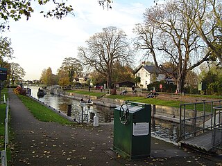
Shepperton Lock is a lock on the River Thames, in England by the left bank at Shepperton, Surrey. It is across the river from Weybridge which is nearby linked by a passenger ferry.

Rivermead Island is a flat grassy island in the River Thames on the reach above Molesey Lock at Sunbury-on-Thames, Surrey, England which is owned mostly by Spelthorne and as to a small part by Elmbridge Borough Council.

The River Wey Navigation and Godalming Navigation together provide a 20-mile (32 km) continuous navigable route from the River Thames near Weybridge via Guildford to Godalming. Both waterways are in Surrey and are owned by the National Trust. The River Wey Navigation connects to the Basingstoke Canal at West Byfleet, and the Godalming Navigation to the Wey and Arun Canal near Shalford. The navigations consist of both man-made canal cuts and adapted parts of the River Wey.

The River Bourne or the Chertsey Bourne is in Berkshire and Surrey; it runs from sources in Windsor Great Park and Swinley Forest through to the River Thames.

The River Bourne is the name given to a Thames tributary in northwest Surrey, England which has a longer tributary, the Windle Brook, that rises nears Bagshot Park in the south of Swinley Forest, Berkshire, merging with it while flowing through villages north of Woking; downstream the Bourne joins the Thames near Weybridge.

Desborough Island is a 112-acre (0.45 km2) manmade island in the River Thames on the reach above Sunbury Lock in Surrey, England. It was formed in the 1930s by the digging of a channel – the Desborough Cut – by the Thames Conservancy as a meander cutoff of narrow width on the right bank. The island and cut are named after Lord Desborough, a chairman of the Thames Conservancy.

Sunbury Lock is a lock complex of the River Thames in England near Walton-on-Thames in north-west Surrey, the third lowest of forty four on the non-tidal reaches. The complex adjoins the right, southern bank about 1⁄2 mile (0.80 km) downstream of the Weir Hotel.

Walton Bridge is a road bridge across the River Thames in England, carrying the A244 between Walton-on-Thames and Shepperton, crossing the Thames on the reach between Sunbury Lock and Shepperton Lock.
Penton Hook Lock is the sixth lowest lock of forty four on the non-tidal reaches of the River Thames in England. It faces an island which was until its construction a pronounced meander and is on the site of its seasonal cutoff. It is against the left bank marking the church parish medieval border of Laleham and Staines upon Thames in Surrey for many centuries. Until 1965 their county was Middlesex. At 266 ft (81 m) it is the third longest lock on the river.

The Shepperton to Weybridge Ferry is a pedestrian and cycle ferry service across the River Thames in Surrey, England. The service has operated almost continuously for over 500 years.

Sunbury Court Island is a long, pedestrianised residential island of houses and bungalows in the River Thames in England on the 'Sunbury and Hampton' or 'Molesey' reach, above Molesey Lock in Sunbury-on-Thames, Surrey, England.

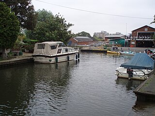
Lock Island is an island in the River Thames in England connected to Shepperton Lock, near Shepperton. Facing the attached by lock-gate bridge mainland is a hedge-lined lawn hosting a café, below and above zones of free short-stay moorings. The Thames River Police have a station on the island. Shepperton Canoe Club and Weybridge Mariners' Boat Club face part of the Weybridge side. The island is connected to Hamhaugh Island by a walkway across the main weir, in turn having a closed-access weir to Hamm Court, Addlestone.

Church Island or Church Eyot is an inhabited island in the River Thames in England on the reach above Penton Hook Lock in Staines-upon-Thames, Spelthorne, Surrey. It is in the upper part of the reach. It is approximately 200 m (660 ft) above Staines Bridge, but is thought by some historians to have been the site of the Roman bridges (Pontes) across the Thames recorded as a waypoint on the Devil's Highway between Londinium (London) and Calleva (Silchester).

The River Wey is a main tributary of the River Thames in south east England. Its two branches, one of which rises near Alton in Hampshire and the other in West Sussex to the south of Haslemere, join at Tilford in Surrey. Once combined, the flow is eastwards then northwards via Godalming and Guildford to meet the Thames at Weybridge. Downstream the river forms the backdrop to Newark Priory and Brooklands. The Wey and Godalming Navigations were built in the 17th and 18th centuries, to create a navigable route from Godalming to the Thames.