
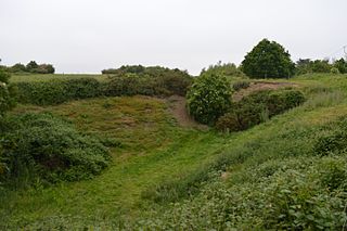
Bramerton Pits is a 0.7-hectare (1.7-acre) geological Site of Special Scientific Interest north of the village of Bramerton in Norfolk on the southern banks of the River Yare. It is a Geological Conservation Review site.

Seale Chalk Pit is a 1.2-hectare (3.0-acre) geological Site of Special Scientific Interest west of Guildford in Surrey. It is a Geological Conservation Review site and part of the Seale Chalk Pit and Meadow 3-hectare (7.4-acre) private nature reserve, which is managed by the Surrey Wildlife Trust.

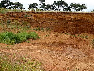
Smokejack Clay Pit is a 56-hectare (140-acre) geological Site of Special Scientific Interest east of Cranleigh in Surrey. It is a Geological Conservation Review site.

Stone Farm Rocks or Stone Hill Rocks is a 0.6-hectare (1.5-acre) geological Site of Special Scientific Interest south of East Grinstead in West Sussex. It is a Geological Conservation Review site.

Moor Mill Quarry, West is a 0.16 hectare geological Site of Special Scientific Interest in How Wood in Hertfordshire. The local planning authority is St Albans City and District Council. It was notified in 1992 as representing the former Moor Mill Quarry SSSI, which was lost to landfill operations. It is listed by the Geological Conservation Review.

Downfield Pit is a 3.6 hectare geological Site of Special Scientific Interest near Ware in Hertfordshire. It is in the Geological Conservation Review in the Thames Pleistocene section, and the local planning authority is East Hertfordshire District Council.

South Lodge Pit is a 0.5 hectare geological Site of Special Scientific Interest in Taplow in Buckinghamshire. It is a Geological Conservation Review site.
St Osyth Pit is a 0.1 hectare geological Site of Special Scientific Interest north of St Osyth in Essex. It is a Geological Conservation Review site.

Hamstead Marshall Pit is a 0.2-hectare (0.49-acre) geological Site of Special Scientific Interest north of Hamstead Marshall in Berkshire. It is a Geological Conservation Review site.

Chillesford Church Pit is a 1.1 hectare geological Site of Special Scientific Interest in Chillesford, south of Saxmundham in Suffolk. It is a Geological Conservation Review site, and it is in the Suffolk Coast and Heaths Area of Outstanding Natural Beauty.

Crag Farm Pit, Sudbourne is a 4.8 hectare geological Site of Special Scientific Interest east of Sudbourne in Suffolk. It is a Geological Conservation Review site, and within the Suffolk Coast and Heaths Area of Outstanding Natural Beauty.

Neutral Farm Pit, Butley is a 1.1 hectare geological Site of Special Scientific Interest in Butley, east of Woodbridge in Suffolk. It is a Geological Conservation Review site, and is in the Suffolk Coast and Heaths Area of Outstanding Natural Beauty.

Red House Farm Pit is a 0.5 hectare geological Site of Special Scientific Interest east of Wickham Market in Suffolk. It is a Geological Conservation Review site, and in the Suffolk Coast and Heaths Area of Outstanding Natural Beauty.
Buckanay Farm Pit, Alderton is a 0.7 hectare geological Site of Special Scientific Interest east of Alderton in Suffolk. It is a Geological Conservation Review site.

Rockhall Wood Pit, Sutton is a 5.3 hectare geological Site of Special Scientific Interest west of Shottisham in Suffolk. It is a Geological Conservation Review site both for its quaternary and neogene deposits.
Hascot Hill Pit is a 0.3 hectare geological Site of Special Scientific Interest south-west of Needham Market in Suffolk. It is a Geological Conservation Review site. It is also a Local Wildlife Site.

Waldringfield Pit is a 0.8 hectare geological Site of Special Scientific Interest between Martlesham Heath and Waldringfield in Suffolk. It is a Geological Conservation Review site.

Houlder and Monarch Hill Pits is a 0.7-hectare (1.7-acre) geological Site of Special Scientific Interest in Upper Halling in Kent. It is a Geological Conservation Review site.
Weybourne Town Pit is a 0.7-hectare (1.7-acre) geological Site of Special Scientific Interest west of Sheringham in Norfolk. It is a Geological Conservation Review site and it is in the Norfolk Coast Area of Outstanding Natural Beauty.
