Red Crag Formation

Last updated
Red Crag Formation
Stratigraphic range:
Late Pliocene - Early Pleistocene
~3.3–2.5  Ma
O
S
D
C
P
T
J
K
Pg
N
Red crag cliff at bawdsey cliff suffolk 30-10-2013.jpg
Red Crag at Bawdsey Cliff in Suffolk
Type Geological formation
Unit of Crag Group
Sub-unitsSizewell Member
Underlies Norwich Crag Formation
Overlies Coralline Crag Formation
Thicknessup to 20 metres (70 ft), locally up to 45 m, offshore up to 70 m
Lithology
Primary Sand
Location
RegionEurope
CountryFlag of England.svg  England

The Red Crag Formation is a geological formation in England. It outcrops in south-eastern Suffolk and north-eastern Essex. The name derives from its iron-stained reddish colour and crag which is an East Anglian word for shells. It is part of the Crag Group, a series of notably marine strata which belong to a period when Britain was connected to continental Europe by the Weald–Artois Anticline, and the area in which the Crag Group was deposited was a tidally dominated marine bay. [1] This bay would have been subjected to enlargement and contraction brought about by transgressions and regressions driven by the 40,000-year Milankovitch cycles.

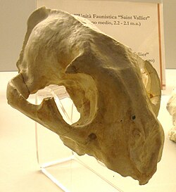
The sediment in the outcrops mainly consists of coarse-grained and shelly sands that were deposited in sand waves (megaripples) that migrated parallel to the shore in a south-westward direction. [2] The most common fossils are bivalves and gastropods [3] that were often worn by the abrasive environment. [1] The most extensive exposure is found at Bawdsey Cliff, which is designated a Site of Special Scientific Interest (SSSI); [4] here a width of around 2 kilometres (1.2 mi) of Crag is exposed. At the coastline by Walton-on-the-Naze, remains of megalodon were found. [5]

The Red Crag Formation at depth in eastern Suffolk clearly has one member, the Sizewell Member, a coarse shelly sand with thin beds of clay and silt. [6] It was interpreted as having been deposited in large scale sand waves where the sea bed was deeper. The overlying Thorpeness Member, was provisionally assigned to the Red Crag based on its lithology but there is more evidence to suggest that it is part of the Norwich Crag Formation.

It has been proposed that the Red Crag started in the late Pliocene and to have possibly extended up into the early Pleistocene, but there is disagreement on more precise dating. According to the British Geological Survey, [7] the Red Crag sits within a segment of time from about 3.3 to 2.5 mya. It is considered that the Red Crag at Walton-on-the–Naze is the oldest and that it was deposited in only a few decades at some time between 2.9 and 2.6 mya. [8] This has led to the UK stratigraphic stage name Waltonian, which is usually correlated with the final Pliocene Reuverian Stage in the Netherlands. [9] There are difficulties in reconciling how the Red Crag equates with international chronological stages. In particular, the start and end dates are poorly defined due to the general paucity of age-diagnostic stratigraphic indicators and the fragmentary nature of the geology. It can also be difficult to separate the Red Crag from the overlying Norwich Crag Formation.
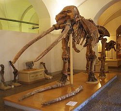
Related Research Articles

Searles Valentine Wood was an English palaeontologist.

The Gelasian is an age in the international geologic timescale or a stage in chronostratigraphy, being the earliest or lowest subdivision of the Quaternary period/system and Pleistocene epoch/series. It spans the time between 2.588 ± 0.005 Ma and 1.806 ± 0.005 Ma. It follows the Piacenzian stage and is followed by the Calabrian stage.

The Piacenzian is in the international geologic time scale the upper stage or latest age of the Pliocene. It spans the time between 3.6 ± 0.005 Ma and 2.588 ± 0.005 Ma. The Piacenzian is after the Zanclean and is followed by the Gelasian.

The Corton Formation is a series of deposits of Middle Pleistocene age found primarily along the coasts of Suffolk and Norfolk in eastern England.

Bramerton Pits Site of Special Interest in Norfolk, England

Bramerton Pits is a 0.7-hectare (1.7-acre) geological Site of Special Scientific Interest north of the village of Bramerton in Norfolk on the southern banks of the River Yare. It is a Geological Conservation Review site.

<i>Ontocetus</i> Extinct genus of carnivores

Ontocetus is an extinct genus of walrus, an aquatic carnivoran of the family Odobenidae, endemic to coastal regions of the southern North Sea and the southeastern coastal regions of the U.S. during the Miocene-Pleistocene. It lived from 13.6 mya—300,000 years ago, existing for approximately 13.3 million years .

Tamiami Formation Late Miocene to Pliocene geologic formation in the southwest Florida peninsula

The Tamiami Formation is a Late Miocene to Pliocene geologic formation in the southwest Florida peninsula.

<i>Orcinus citoniensis</i> Extinct species of killer whale

Orcinus citoniensis is an extinct species of killer whale identified in the Late Pliocene of Italy and the Early Pleistocene of England. It was smaller than the modern killer whale, 4 m (13 ft) versus 7 to 10 m, and had around 8 more teeth in its jaw. It may have resembled the modern killer whale in appearance, and could represent a transitional species between the modern killer whale and other dolphins. O. citoniensis may have hunted large fish and squid in pods, and coexisted with other large predators of the time such as the orcinine Hemisyntrachelus and the extinct shark Otodus megalodon.

Norwich Crag Formation

The Norwich Crag Formation is a stratigraphic unit of the British Pleistocene Epoch. It is the second youngest unit of the Crag Group, a sequence of four geological formations spanning the Pliocene to Lower Pleistocene transition in East Anglia. It was deposited between approximately 2.4 and 1.8 million years ago, during the Gelasian Stage.

The geology of Essex in southeast England largely consists of Cenozoic marine sediments from the Palaeogene and Neogene periods overlain by a suite of superficial deposits of Quaternary age.

The geology of Norfolk in eastern England largely consists of late Mesozoic and Cenozoic sedimentary rocks of marine origin covered by an extensive spread of unconsolidated recent deposits.

Coralline Crag Formation

The Coralline Crag Formation is a geological formation in England. The Coralline Crag Formation is a series of marine deposits found near the North Sea coast of Suffolk and characterised by bryozoan and mollusc debris. The deposit, whose onshore occurrence is mainly restricted to the area around Aldeburgh and Orford, is a series of bioclastic calcarenites and silty sands with shell debris, deposited during a short-lived warm period at the start of the Pliocene Epoch of the Neogene Period. Small areas of the rock formation are found in locations such as Boyton and Tattingstone to the south of Orford as well as offshore at Sizewell.

Crag Group

The Crag Group is a geological group outcropping in East Anglia, UK and adjacent areas of the North Sea. Its age ranges from approximately 4.4 to 0.478 million years BP, spanning the late Pliocene and early to middle Pleistocene epochs. It comprises a range of marine and estuarine sands, gravels, silts and clays deposited in a relatively shallow-water, tidally-dominated marine embayment on the western margins of the North Sea basin. The sands are characteristically dark green from glauconite but weather bright orange, with haematite 'iron pans' forming. The lithology of the lower part of the Group is almost entirely flint. The highest formation in the Group, the Wroxham Crag, contains over 10% of far-travelled lithologies, notably quartzite and vein quartz from the Midlands, igneous rocks from Wales, and chert from the Upper Greensand of southeastern England. This exotic rock component was introduced by rivers such as the Bytham River and Proto-Thames.

The Naze SSSI

The Naze SSSI is a 22 hectare geological Site of Special Scientific Interest on The Naze peninsula north of Walton-on-the-Naze in Essex. It is a Geological Conservation Review site both for its Pleistocene fossils and for its birds. It is part of The Naze Nature Reserve, which is managed by the Essex Wildlife Trust.

This article describes the geology of the Broads, an area of East Anglia in eastern England characterised by rivers, marshes and shallow lakes (‘broads’). The Broads is designated as a protected landscape with ‘status equivalent to a national park’.

Chillesford Church Pit

Chillesford Church Pit is a 1.1 hectare geological Site of Special Scientific Interest in Chillesford, south of Saxmundham in Suffolk. It is a Geological Conservation Review site, and it is in the Suffolk Coast and Heaths Area of Outstanding Natural Beauty.

Bawdsey Cliff

Bawdsey Cliff is a 17.4 hectare geological Site of Special Scientific Interest north-east of Felixstowe in Suffolk. It is a Geological Conservation Review site, and is in the Suffolk Coast and Heaths Area of Outstanding Natural Beauty.

Rockhall Wood Pit, Sutton

Rockhall Wood Pit, Sutton is a 5.3 hectare geological Site of Special Scientific Interest west of Shottisham in Suffolk. It is a Geological Conservation Review site both for its quaternary and neogene deposits.

Hascot Hill Pit

Hascot Hill Pit is a 0.3 hectare geological Site of Special Scientific Interest south-west of Needham Market in Suffolk. It is a Geological Conservation Review site. It is also a Local Wildlife Site.

Ludham Borehole

The Ludham Borehole was a geological research borehole drilled in 1959 near Ludham, Norfolk, UK. A continuous core sample of late Pliocene and early Pleistocene sediments of the Crag Group was recovered. Analysis allowed biostratigraphic zonal schemes for fossil pollen, foraminifera, mollusca and dinoflagellates to be constructed for horizons of the Red Crag and Norwich Crag Formations, and for these formations to be thus correlated with strata of equivalent age in the North Sea basin and north-west Europe.

References

  1. 1 2 Lee, Woods & Moorlock (2015), pp. 110-111.
  2. Dixon, R. G. (1979). "Sedimentary facies in Red Crag (Lower Pleistocene, East Anglia)". Proceedings of the Geologists' Association. 90 (3): 117–132. doi:10.1016/s0016-7878(79)80014-0.
  3. Dixon, R. G. (1977). Studies in mollusca of the Red Crag (Pleistocene, East Anglia) (PhD). University of London . Retrieved 18 April 2018 via British Library.
  4. "Designated Sites: Bawdsey Cliff" (PDF). Natural England . Retrieved 5 April 2018.
  5. UK Fossils - Walton on the Naze
  6. Zalasiewicz, J. A.; Mathers, S. J.; Hughes, M. J.; Gibbard, P. L.; Peglar, S. M.; Harland, R.; Nicholson, R. A.; Boulton, G. S.; Cambridge, P.; Wealthall, G. P. (19 December 1988). "Stratigraphy and palaeoenvironments of the Red Crag and Norwich Crag formations between Aldeburgh and Sizewell, Suffolk, England". Philosophical Transactions of the Royal Society B . 322 (1210): 221–272. doi: 10.1098/rstb.1988.0125 .
  7. Lee, Woods & Moorlock (2015), pp. 92-93.
  8. Head, M. J. (1998). "Pollen and dinoflagellates from the Red Crag at Walton on the Naze, Essex". Geological Magazine. 135: 803–817. doi:10.1017/S0016756898001745.
  9. "Global Chronostratigraphical Correlation Table for the Last 2.7 Million Years". Subcommission on Quaternary Stratigraphy. University of Cambridge. 2011. Retrieved 5 August 2016.
  10. 1 2 Chatwin, C.P. (1954). East Anglia and adjoining areas. British Regional Geology (3rd ed.). London: Her Majesty's Stationery Office.

Bibliography

Coordinates: 51°59′58″N1°25′16″E / 51.9994°N 1.4211°E / 51.9994; 1.4211