The Missoula Floods refer to the cataclysmic floods that swept periodically across eastern Washington and down the Columbia River Gorge at the end of the last ice age. The glacial flood events have been researched since the 1920s. These glacial lake outburst floods were the result of periodic sudden ruptures of the ice dam on the Clark Fork River that created Glacial Lake Missoula. After each ice dam rupture, the waters of the lake would rush down the Clark Fork and the Columbia River, flooding much of eastern Washington and the Willamette Valley in western Oregon. After the rupture, the ice would reform, creating Glacial Lake Missoula again.

The London Clay Formation is a marine geological formation of Ypresian age which crops out in the southeast of England. The London Clay is well known for its fossil content. The fossils from the lower Eocene rocks indicate a moderately warm climate, the tropical or subtropical flora. Though sea levels changed during the deposition of the clay, the habitat was generally a lush forest – perhaps like in Indonesia or East Africa today – bordering a warm, shallow ocean.

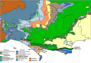
Dorset is a county in South West England on the English Channel coast. Covering an area of 2,653 square kilometres (1,024 sq mi); it borders Devon to the west, Somerset to the north-west, Wiltshire to the north-east, and Hampshire to the east. The great variation in its landscape owes much to the underlying geology which includes an almost unbroken sequence of rocks from 200 Ma to 40 Ma and superficial deposits from 2 Ma to the present. In general the oldest rocks appear in the far west of the county, with the most recent (Eocene) in the far east. Jurassic rocks also underlie the Blackmore Vale and comprise much of the coastal cliff in the west and south of the county; and although younger Cretaceous rocks crown some of the highpoints in the west, they are mainly to be found in the centre and east of the county.

Oxshott Heath and Woods is an area of woods and heathland in Oxshott, Surrey, England covering approximately 200 acres (81 ha), as an area of common land. It is owned by a local authority, however historic rights of access and gathering dead wood where necessary for individual fires are shared and exercised by landowners in the parish of Oxshott which has existed since the end of the 19th century, created from the east of the village of Stoke D'Abernon which in this area was extremely scantly populated until the construction of Oxshott railway station.

Lithostratigraphy is a sub-discipline of stratigraphy, the geological science associated with the study of strata or rock layers. Major focuses include geochronology, comparative geology, and petrology. In general a stratum will be primarily igneous or sedimentary relating to how the rock was formed.

The River Tillingbourne runs along the south side of the North Downs and joins the River Wey at Guildford. Its source is near Tilling Springs to the north of Leith Hill at grid reference TQ143437 and it runs through Friday Street, Abinger Hammer, Gomshall, Shere, Albury, Chilworth and Shalford. The source is a semi-natural uninhabited area. The catchment is situated on sandstone which has a low rate of weathering. The Tillingbourne is 24 km (15 mi) in length.

Combe Bottom is a 42.1-hectare (104-acre) biological Site of Special Scientific Interest north of Shere in Surrey. It is designated a Local Nature Reserve called Shere Woodlands, and is managed by the Surrey Wildlife Trust.

Melbourne Bone Bed is a paleontological site located at Crane Creek in Melbourne, in the U.S. state of Florida. This site contains fossils from the Late Pleistocene period 20,000 to 10,000 years before present. The fossils include extinct animals such as varieties of camels, giant armadillos, giant beavers, giant bison, giant ground sloths, mammoths, mastodons, saber-toothed cats and tapirs.

The London Basin is an elongated, roughly triangular sedimentary basin approximately 250 kilometres (160 mi) long which underlies London and a large area of south east England, south eastern East Anglia and the adjacent North Sea. The basin formed as a result of compressional tectonics related to the Alpine orogeny during the Palaeogene period and was mainly active between 40 and 60 million years ago.

The Hampshire Basin is a geological basin of Palaeogene age in southern England, underlying parts of Hampshire, the Isle of Wight, Dorset, and Sussex. Like the London Basin to the northeast, it is filled with sands and clays of Paleocene and younger ages and it is surrounded by a broken rim of chalk hills of Cretaceous age.

Sheepleas is a 99.9-hectare (247-acre) biological and geological Site of Special Scientific Interest east of Guildford in Surrey. It is a Geological Conservation Review site and a Local Nature Reserve. It is owned by Surrey County Council and managed by the Surrey Wildlife Trust.

Upper Common Pits is a 3-hectare (7.4-acre) geological Site of Special Scientific Interest north of Gomshall in Surrey. It is a Geological Conservation Review site.

Simi Valley is a synclinal valley in Southern California in the United States. It is an enclosed or hidden valley surrounded by mountains and hills. It is connected to the San Fernando Valley to the east by the Santa Susana Pass and the 118 freeway, and in the west the narrows of the Arroyo Simi and the Reagan Freeway connect to Moorpark and Ventura, California. The relatively flat bottom of the valley contains soils formed from shales, sandstones, and conglomerates eroded from the surrounding hills of the Santa Susana Mountains to the north, which separate Simi Valley from the Santa Clara River Valley, and the Simi Hills.
Holmbury Hill is a wooded area of 261 metres (856 ft) above sea level and the site of an Iron Age hillfort. The Old Saxon word "holm" can be translated as hill and "bury" means fortified place. It sits along the undulating Greensand Ridge its summit being 805 feet (245 m) from the elevated and tightly clustered small village of Holmbury St. Mary in Surrey, England which was traditionally part of Shere, 8 kilometres (5.0 mi) away.

The Norwich Crag Formation is a stratigraphic unit of the British Pleistocene Epoch. It is the second youngest unit of the Crag Group, a sequence of four geological formations spanning the Pliocene to Lower Pleistocene transition in East Anglia. It was deposited between approximately 2.4 and 1.8 million years ago, during the Gelasian Stage.
Geology of Surrey. Towards the beginning of the Cretaceous age Surrey alternated between a fresh-to-brackish water embayment depositing Hastings Beds and Weald Clay, comprising shales and mudstones that are often finely banded. Offshore muds of the Atherfield Clay were deposited followed by shallow marine sands of the Hythe, Sandgate and Folkestone Beds. Where not eroded to lower heights, there is then a marine layer of the sands of the Hythe Beds topped by chert seen on today's remaining Greensand Hills. Instead of the mudstone and sandstone-producing three beds mentioned before Hythe Beds, west of Dorking the marine Bargate Beds made of calcareous sandstone were deposited. The Folkestone Beds contain phosphatic and iron-rich nodules, which locally yield a rich fossil fauna of marine shells.

Froghall Brickworks is a 0.26 hectare geological Site of Special Scientific Interest east of Chalfont St Giles in Buckinghamshire.

Graeme Hendrey Wood is a 10-hectare (25-acre) nature reserve east of Bletchingley in Surrey. It is managed by the Surrey Wildlife Trust.

Tilburstow Hill is a 9-hectare (22-acre) nature reserve south-east of Godstone in Surrey. It is managed by the Surrey Wildlife Trust.


