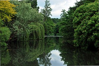
Syon Park is the 56.6 hectare garden of Syon House, the London home of the Duke of Northumberland in Isleworth in the London Borough of Hounslow. It was landscaped by Capability Brown in the 18th century, and it is Grade I listed by English Heritage under the Historic Buildings and Ancient Monuments Act 1953 for its special historic interest. The 56.6 hectare main gardens are a Site of Borough Importance for Nature Conservation, Grade I, and the flood meadows next to the River Thames are a biological Site of Special Scientific Interest (SSSI) and a Site of Metropolitan Importance for Nature Conservation.

Colyers Hanger is a 26.6-hectare (66-acre) biological Site of Special Scientific Interest south-east of Guildford in Surrey. It is a Nature Conservation Review site, Grade 2 and is part of St Martha's Hill and Colyer's Hanger nature reserve, which is managed by the Surrey Wildlife Trust.

Hankley Farm is a 2.4-hectare (5.9-acre) biological Site of Special Scientific Interest (SSSI) west of Elstead in Surrey.

Langham Pond is a 26.7-hectare (66-acre) biological Site of Special Scientific Interest north of Egham in Surrey.

Netherside Stream Outcrops is a 2.9-hectare (7.2-acre) geological Site of Special Scientific Interest north-east of Haslemere in Surrey. It is a Geological Conservation Review site.

Quarry Hangers is a 28.5-hectare (70-acre) biological Site of Special Scientific Interest south-west of Caterham in Surrey. An area of 11 hectares is a nature reserve managed by the Surrey Wildlife Trust.

Seale Chalk Pit is a 1.2-hectare (3.0-acre) geological Site of Special Scientific Interest west of Guildford in Surrey. It is a Geological Conservation Review site and part of the Seale Chalk Pit and Meadow 3-hectare (7.4-acre) private nature reserve, which is managed by the Surrey Wildlife Trust.
Staffhurst Wood is a 51-hectare (130-acre) biological Site of Special Scientific Interest south of Oxted in Surrey. It is a Nature Conservation Review site, Grade 2. An area of 38.1 hectares is a Local Nature Reserve, which is owned by Surrey County Council and managed by the Surrey Wildlife Trust.

Upper Common Pits is a 3-hectare (7.4-acre) geological Site of Special Scientific Interest north of Gomshall in Surrey. It is a Geological Conservation Review site.

Whitmoor Common is a 166-hectare (410-acre) biological Site of Special Scientific Interest on the northern outskirts of Guildford in Surrey. It is part of the Thames Basin Heaths Special Protection Area and the 184.9-hectare (457-acre) Whitmoor and Rickford Commons Local Nature Reserve, which is owned by Surrey County Council and managed by the Surrey Wildlife Trust.

Woldingham and Oxted Downs is a 128.4-hectare (317-acre) biological Site of Special Scientific Interest east of Caterham in Surrey.

Blow's Down is a 33.1 hectare biological Site of Special Scientific Interest in Dunstable in Bedfordshire. It was notified in 1989 under Section 28 of the Wildlife and Countryside Act 1981, and the local planning authority is Central Bedfordshire Council. The site forms around half of the 62.3 hectare Blow's Downs nature reserve, which is managed by the Wildlife Trust for Bedfordshire, Cambridgeshire and Northamptonshire.

Frogmore Meadows is a 4.6 hectare biological Site of Special Scientific Interest in Hertfordshire and Buckinghamshire, north of the village of Chenies. It consists of two meadows in the Chilterns Area of Outstanding Natural Beauty, next to the River Chess, one of which is a Hertfordshire and Middlesex Wildlife Trust nature reserve. The planning authorities are Three Rivers District Council, Dacorum Borough Council and Chiltern District Council.

West End Common is a 70.3-hectare (174-acre) Local Nature Reserve on the north-western outskirts of Esher in Surrey. It is owned and managed by Elmbridge Borough Council. It is part of Esher Commons, which is a Site of Special Scientific Interest.

Betchworth Quarry and Lime Kilns is a 27-hectare (67-acre) nature reserve west of Betchworth in Surrey. It is managed by the Surrey Wildlife Trust. It is part of the Mole Gap to Reigate Escarpment Site of Special Scientific Interest and Special Area of Conservation.
Brockham Limeworks is a 45-hectare (110-acre) nature reserve north of Brockham in Surrey. It is owned by Surrey County Council and managed by the Surrey Wildlife Trust. Part of it is a Scheduled Monument, and it is part of the Mole Gap to Reigate Escarpment Site of Special Scientific Interest and Special Area of Conservation.

St Martha's Hill and Colyer's Hanger is a 38-hectare (94-acre) nature reserve north of Chilworth in Surrey. It is owned by the Albury Estate and managed by the Surrey Wildlife Trust on behalf of Surrey County Council. Colyers Hanger is a Site of Special Scientific Interest and a Nature Conservation Review site, Grade 2. Earth circles, which are probably associated with tree planting for Chilworth Manor, are a Scheduled Monument.

Charleshill SSSI is a 10.1-hectare (25-acre) biological Site of Special Scientific Interest west of Elstead in Surrey. It is part of Thundry Meadows nature reserve, which is owned and managed by the Surrey Wildlife Trust

Gracious Pond is a 14-hectare (35-acre) nature reserve in Chobham in Surrey. It is managed by the Surrey Wildlife Trust. It is part of Chobham Common Site of Special Scientific Interest.


