This article needs additional citations for verification .(June 2024) |
| Maryon Park | |
|---|---|
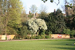 Maryon Park, London | |
 | |
| Type | • Public park • Urban park |
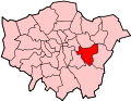
| Location | Charlton, Greenwich, London, England, United Kingdom |
| Coordinates | 51°29′20″N0°02′35″E / 51.489°N 0.043°E |
| Operated by | Greenwich London Borough Council |
| Status | Open year round |
| Website | "Marion Park" (descriptive page on Maryon Park at greenwich.gov.uk, the Greenwich London Borough Council's official website) |
Maryon Park is an urban public park located in Charlton in the Royal Borough of Greenwich, London, United Kingdom. It is situated on the A206 road south of the Thames Barrier, and is accessible from Woolwich Road, Charlton Lane and Thorntree Road. It is part of the Maryon Wilson Park and Gilbert's Pit Local Nature Reserve. [1] [2]