New Eltham | |
---|---|
![]() Typical 1930s New Eltham housing in Thaxted Road | |
Location within Greater London | |
OS grid reference | TQ440730 |
London borough | |
Ceremonial county | Greater London |
Region | |
Country | England |
Sovereign state | United Kingdom |
Post town | LONDON |
Postcode district | SE9 |
Dialling code | 020 |
Police | Metropolitan |
Fire | London |
Ambulance | London |
UK Parliament | |
London Assembly | |
New Eltham is a suburban area of South East London, England, primarily in the Royal Borough of Greenwich with some parts in the London Borough of Bexley. It is located south east of Eltham and north west of Sidcup.
New Eltham is a largely residential suburb of Greater London developed on former farmland to the south of Eltham in and around the small hamlet and crossroads of Pope Street, centred around what is today Avery Hill Road. [1] On the main building of Wyborne School (Footscray Road) there is a sign clearly identifying it as "Pope Street" School, built in 1904.
New Eltham railway station was opened as Pope Street Station in April 1878, twelve years after the opening of the Dartford Loop Line. The station was renamed New Eltham in 1886 although Pope Street was retained as a suffix until 1927. [2] [3] In 1974 the bridge (crossing the railway line) at Avery Hill Road was widened to allow buses to cross it. This replaced a narrow iron bridge which only had a separate path on one side for pedestrians.
The Beehive public house was rebuilt in 1897. [4] Most of New Eltham's housing dates from the 1930s. A library was built in 1931. [1]
As part of London's Cold War civil defences, a rectangular windowless blockhouse was built in 1954 behind New Eltham library. It served as the Woolwich Borough Control and when Woolwich merged with Greenwich in 1965 it took over the role as the Greenwich Borough Control. The control was part of the South East London Group reporting to the Regional Group War HQ at Chislehurst and later to Pear Tree House. [5]
Until the mid-1970s New Eltham had 3 butchers, 2 greengrocers, 3 grocers, 2 toy shops, a shoe repairer, 2 barbers, a radio and television repair shop, a clothing and material store, timber yard, cycle sales and repairs, 2 motor spares, hardware store, 2 dairies and a fishmongers. The Co-operative supermarket was previously a series of smaller separate purpose Co-op shops: a greengrocer, a chemist, butcher, and grocery store. A fishmongers later became a fish and chips shop (and still is as of 2021). Behind this, in what is now the car park was the Co-op dairy; the other (Unigate) was in Green Lane near Fiveways in what is now a small business park.
Championship side Charlton Athletic has a training ground in New Eltham, down Sparrows Lane. [1] The area's other football teams include Newpark F.C., which played in the South London Football Alliance Division 3 and are currently holders of the Beckenham Hospital Cup, and one New Eltham team, playing in the London & Kent Borders League and based at the STC Ground on Ivor Grove
Footscray RUFC is located on Footscray Road. It has three men's team (the first team playing in the Shepherd Neame Kent 2 league), a ladies team and minis rugby. [6]
RACS Cricket Club are based in the area.
New Eltham also has a running club, New Eltham Joggers. [7] A section of the South East London Green Chain walk passes through New Eltham. [8]
New Eltham Operatic Society is a member of the National Operatic and Dramatic Association. [9] Dance classes are held above the Co-op store.
Near the railway station is the library, the Co-operative food store, a cluster of small shops and the Post Office. Larger chain stores may be found in nearby Eltham and Sidcup high streets. The public house was refurbished in 2009.
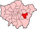
New Eltham borders Avery Hill to the north and north east, Sidcup to the east and south east, Chislehurst to the south, Mottingham to the west and Eltham to the north west.
New Eltham station serves the area, with services to Central London and Gravesend. New Eltham is served by several Transport for London bus services connecting it with Beckenham, Bexleyheath, Bromley, Catford, Chislehurst, Eltham, Lewisham, New Addington, New Cross, Sidcup and Swanley.
Chislehurst is a suburban district of south-east London, England, in the London Borough of Bromley. It lies east of Bromley, south-west of Sidcup and north-west of Orpington, 10 miles (16 km) south-east of Charing Cross. Before the creation of Greater London in 1965, it was in Kent. According to the 2021 census, Chislehurst has a population of 15,600.
Mottingham is a district of south-east London, England, which straddles the border of both the London Borough of Bromley and the Royal Borough of Greenwich. It is located south west of Eltham, 1.5 miles. It was historically within the county of Kent.
Sidcup is an area of south-east London, England, primarily in the London Borough of Bexley. It is 11.3 miles (18.2 km) south-east of Charing Cross, bordering the London Boroughs of Bromley and Greenwich. It was part of Kent prior to the creation of Greater London in 1965.
The London Borough of Bromley is a borough in London, England. It borders the county of Kent, of which it formed part of until 1965. The borough's population in the 2021 census was 329,991. It is named after Bromley, its principal district. Other districts are Penge, Hayes, West Wickham, Chislehurst, Beckenham and Orpington. The local authority is Bromley London Borough Council.
Lewisham is an area of southeast London, England, six miles south of Charing Cross. It is the principal area of the London Borough of Lewisham, and was within the historic county of Kent until 1889. It is identified in the London Plan as one of 35 major centres in Greater London, with a large shopping centre and street market. Lewisham had a population of 60,573 in 2011.
Eltham is a district of southeast London, England, within the Royal Borough of Greenwich. It is 8.7 miles (14.0 km) east-southeast of Charing Cross, and is identified in the London Plan as one of 35 major centres in Greater London. The three wards of Eltham North, South and West have a total population of 35,459. 88,000 people live in Eltham.
Foots Cray is an area of South East London, England, within the London Borough of Bexley. Prior to 1965 it was in the historic county of Kent. It is located south-east of Sidcup, north of Orpington and north west of Swanley.
Eltham railway station is in the Well Hall area of Eltham, South East London, within the Royal Borough of Greenwich. It is 10 miles 68 chains (17.5 km) measured from London Victoria. It is in Travelcard Zone 4.
The Dartford Loop Line is one of three lines linking London with Dartford in Kent, England. It lies to the south of the other two: the North Kent Line and the Bexleyheath Line.
Hither Green is a railway station located in Hither Green in the London Borough of Lewisham, south-east London. It is 7 miles 16 chains (11.6 km) down the line from London Charing Cross and is situated between Lewisham and either Grove Park or Lee depending on the route.
Mottingham railway station is a station situated on Court Road between Eltham and Mottingham, in the Royal Borough of Greenwich, south-east London. It is 9 miles 40 chains (15.3 km) down the line from London Charing Cross the terminus of the Dartford loop line. The station is located in Travelcard Zone 4 between Lee and New Eltham.
New Eltham railway station is in the Royal Borough of Greenwich in south-east London. It is 10 miles 32 chains (16.7 km) down the line from London Charing Cross.
Sidcup railway station serves Sidcup, south-east London, within the London Borough of Bexley. It is 11 miles 73 chains (19.2 km) down the line from London Charing Cross.
Eltham was a constituency in Greater London created in 1983 and represented in the House of Commons of the UK Parliament from 1997 until its abolition for the 2024 general election by Clive Efford of the Labour Party.
The region of Greater London, including the City of London, is divided into 75 parliamentary constituencies which are sub-classified as borough constituencies, affecting the type of electoral officer and level of expenses permitted. Since the general election of July 2024, 59 are represented by Labour MPs,9 by Conservative MPs, 6 by Liberal Democrat MPs, and 1 by an independent MP.
The South East London Green Chain, also known as the Green Chain Walk, is a linked system of open spaces between the River Thames and Crystal Palace Park in London, England. In 1977 four London boroughs and the Greater London Council created this Green Chain of 300 open spaces to protect them from building activity. The four London boroughs are Bexley, Bromley, Lewisham and Greenwich. More recently it has been extended to include sections in Southwark. Many parts of the system are also part of the Capital Ring route.
Longlands is an area of South East London that straddles the boundary of both the London Borough of Bexley and the Royal Borough of Greenwich. It lies north west of Sidcup and south east of Eltham.
Horn Park is an area of south east London south west of Eltham. It is located 12.5 km (7.8 mi) southeast of Charing Cross on the southwest edge of the Royal Borough of Greenwich and borders both the London Borough of Lewisham and the London Borough of Bromley. There is a public park also named Horn Park and two schools in the area. The River Quaggy flows northward though Horn Park, and the suburb is covered by the postcode district SE12, which was previously called the Lee postal district. There is community centre located in Horn Park Estate on Sibthorpe Road, that hosts a number of activities, such as Christian, council and MP meetings, and numerous classes including dance, karate and English.
Well Hall is a place to the north of Eltham in the Royal Borough of Greenwich in southeast London, England, with no present formal boundaries and located 13.5 km (8.4 mi) east-southeast of Charing Cross. In the past Well Hall was the grounds of a manor house, and then a hamlet. Today it is a largely residential suburb and housing estate absorbed by the development of Eltham and London. It is centred on the main road between Eltham and Woolwich, on which many shops and businesses are located. Several major A roads including the South Circular Road and A2 road pass through the area, as does a railway line, serving Eltham station which is located in Well Hall. The Postcode that covers Well Hall and most of the Eltham area is SE9, and the 020 dialing covers the entire Royal Borough of Greenwich. Well Hall is split across two electoral wards, Eltham West on the west side of Well Hall Road, and Eltham North on the east side of Well Hall Road. In 2015 the population of these two wards combined was recorded as 24,621, although the wards cover a larger area than just Well Hall.
Avery Hill is an area of South East London mainly within Royal Borough of Greenwich, and with some parts in the London Borough of Bexley. It is located east of Eltham and north west of Sidcup. It is believed that the area is named after an aviary formerly located in the area.