Listed buildings
| Name | Location | Type | Completed [note 1] | Date designated | Grid ref. [note 2] Geo-coordinates | Entry number [note 3] | Image |
|---|---|---|---|---|---|---|---|
| 1 and 3, Bexley High Street | Bexley | Houses | Late 18th century | 17 December 1980 | TQ 49304 73616 | 1064242 |  |
| 2 K6 telephone kiosks outside Number 11 | Bourne Road, Bexley | Telephone booths | 1935 | 13 July 1987 | TQ 49582 73654 | 1064213 |  |
| 7 and 9, Bexley High Street, Bexley | Bexley | Houses | 18th century | 17 December 1980 | TQ 49326 73615 | 1359376 |  |
| 8 Upton Road | Bexleyheath | House | c.1856 | 17 December 1980 | TQ 48162 75320 51°27′27″N0°07′52″E / 51.4575°N 0.1312°E | 1064205 |  Upload Photo |
| 10–16, Burnt Oak Lane | Sidcup | Houses | 1874 | 11 September 1985 | TQ 46163 72993 51°26′14″N0°06′05″E / 51.4371°N 0.1015°E | 1359401 |  |
| 16, North Cray Road | Bexley | House | Late 18th century | 17 December 1980 | TQ 49726 73373 | 1064235 |  |
| 25 and 27 Halfway Street | Sidcup | Houses | 15th or 16th century | 17 December 1980 | TQ 46094 72917 | 1188383 | 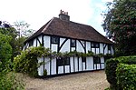 |
| 28 and 30, Erith High Street | Erith | Houses | 18th century | 3 July 1973 | TQ 51557 78091 | 1064227 |  |
| Number 33 (Farm Cottage) and Number 35 | Halfway Street, Sidcup | Houses | Probably 16th century | 17 December 1980 | TQ 46051 72920 51°26′11″N0°05′59″E / 51.4365°N 0.0998°E | 1359412 | Upload Photo |
| 34, North Cray Road | Bexley | House | c. 17th or early 18th century | 17 December 1980 | TQ 49698 73289 | 1188453 | 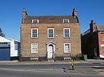 |
| 34 and 36, Bexley High Street | Bexley | Houses | 1787 | 17 December 1980 | TQ 49424 73546 | 1064246 |  |
| 56–62, Bexley Lane | Crayford | House | 18th century | 17 December 1980 | TQ 51182 74836 | 1359380 |  |
| 57 and 59, Bexley High Street, Bexley | Bexley | Houses | Late 17th or early 18th century | 1 October 1953 | TQ 49448 73590 | 1359377 |  |
| 64, Bexley Lane | Crayford | House | Late 18th or early 19th century | 17 December 1980 | TQ 51171 74831 | 1188219 |  |
| 71 Danson Road | Bexleyheath | House | 1934 | 18 July 2003 | TQ 47623 74859 | 1390524 |  |
| 101–105, Bexley High Street, Bexley | Bexley | Houses | Mid-18th century | 5 August 1974 | TQ 49656 73527 | 1359378 |  |
| Number 152 (Rose Cottage) and Number 154 | North Cray Road, North Cray | Houses | c. 16th–17th centuries | 17 December 1980 | TQ 48803 72307 51°25′49″N0°08′21″E / 51.4302°N 0.1391°E | 1064237 | 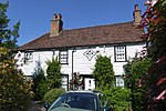 |
| 172, 172A and 172B, Old Road | Crayford | Houses | 17th century | 17 December 1980 | TQ 51261 74994 | 1064223 |  |
| 180–188, Rectory Lane | Foots Cray | Houses | 1737 | 25 August 1954 | TQ 47379 71011 | 1188531 |  |
| Abbeyhill (Montrose Park Residents Club) | 158 Hurst Road, Sidcup | House | c.1830 | 17 December 1980 | TQ 47143 73062 | 1064230 |  |
| Albion Villas | 65 and 67 Woolwich Road, Bexleyheath | Houses | 1866 | 3 December 1982 | TQ 49221 75504 | 1064209 |  |
| Barn at Hall Place | Bourne Road, Bexley | Barn | 17th century | 1 October 1953 | TQ 50210 74328 | 1359381 |  |
| Bexley College (former Erith Technical Institute) including attached walls railings and gatepiers | Erith Road, Belvedere | School | 1906 | 23 July 1999 | TQ 49823 78412 | 1387547 |  |
| Bowling Pavilion, Foots Cray Place | Rectory Lane, Foots Cray | Garden building | 1903 | 17 July 1989 | TQ 47421 71610 | 1064215 |  |
| Brooklands | 38 Bexley Lane, Crayford | House | 18th century | 20 May 1952 | TQ 51240 74862 | 1188215 |  |
| Caretaker's House at Lamorbey Park | Burnt Oak Lane, Sidcup | House | c.1790 | 17 December 1980 | TQ 46540 73210 | 1064221 |  |
| Chapel House | 497 Blackfen Road, Sidcup | House | 1761 | 17 December 1980 | TQ 47296 74256 | 1064248 |  |
| Christ Church Parish Church | Broadway, Bexleyheath | Church | 1877 | 17 December 1980 | TQ 48855 75334 | 1359404 |  |
| Christ Church Vicarage | Broadway, Bexleyheath | House | 1868 | 17 December 1980 | TQ 48894 75365 | 1064219 |  |
| Clock Tower at west angle of Market Place | Broadway, Bexleyheath | Clocktower | 1911 | 17 December 1980 | TQ 49236 75239 | 1064220 |  |
| Coal Duty Boundary Marker (in the fence to the back of the garden of Number 57 Baldwyn's Park) and adjacent iron bollard | Tile Kiln Lane, Bexley | Coal tax post | 1861 | 17 December 1980 | TQ 50671 72493 | 1188545 |  |
| Coal Duty Boundary Marker (in the grounds of the Old Orchard) | East Rochester Way, Bexley | Coal tax post | 1861 | 17 December 1980 | TQ 51197 73967 | 1064226 | Upload Photo |
| Coal Duty Boundary Marker (on foreshore, at mouth of River Darenth, West Bank) | near Wallhouse Road, North End | Coal tax post | 1851 | 17 December 1980 | TQ 54013 78078 | 1064206 |  |
| Coal Duty Boundary Marker (on the east side of Railway Line, north side of Stanham River) | Willow Walk, Crayford | Coal tax post | 1851 | 17 December 1980 | TQ 53146 75093 | 1064208 | Upload Photo |
| Coal Duty Boundary Marker (on the south side of Number 1) | Dartford Road, Bexley | Coal tax post | 1861 | 17 December 1980 | TQ 50701 72875 | 1188345 |  |
| Coal Duty Boundary Marker (on west side opposite Number 205) | Station Road, Crayford | Coal tax post | 1861 | 17 December 1980 | TQ 51640 73865 | 1359398 |  |
| Cray Hall | 141 North Cray Road, North Cray | House | c.1830 | 17 December 1980 | TQ 48481 71142 | 1064240 | Upload Photo |
| Cray House | 96 Bexley High Street, Bexley | House | Late 18th century | 1 October 1953 | TQ 49668 73488 | 1064247 |  |
| Crayford War Memorial in grounds of Crayford Manor | Grounds of Crayford Manor, Mayplace Road East, Dartford, Crayford, London DA1 4HB | War memorial | 1954 | 13 November 2012 | TQ5099375500 | 1410311 |  |
| The Crook Log Public House | Crook Log, Bexleyheath | Pub | 18th century | 17 December 1980 | TQ 47818 75496 | 1359408 |  |
| Dairy at Lamorbey Park | Burnt Oak Lane, Sidcup | Dairy | c.1790 | 17 December 1980 | TQ 46522 73182 | 1359406 | Upload Photo |
| Dower House | North Cray Road, North Cray | House | c.1820 | 17 December 1980 | TQ 48751 72138 | 1294717 |  |
| East Wickham Farmhouse | Wickham Street, East Wickham | House | Possibly 15th century | 17 December 1980 | TQ 46618 76859 | 1359400 | Upload Photo |
| Erith (Christ Church) War Memorial | Christ Church, Victoria Road, Erith DA8 3AN | War memorial | 10 April 2017 | TQ5122977911 | 1445231 |  | |
| Erith Library | Walnut Tree Road, Erith | Library | 1906 | 7 March 1996 | TQ 51322 78072 | 1255449 | 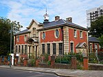 |
| First World War Memorial at St John the Baptist Church, Erith | St John the Baptist Churchyard, West Street, Erith, London DA8 1AN | War memorial | 1921 | 19 October 2017 | TQ5077978700 | 1445491 |  |
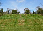
| Five Arch Bridge | North Cray Road, Foots Cray Meadows, North Cray | Bridge | c.1781 | 17 December 1980 | TQ 48227 71880 | 1188471 |  |
| Former Fosters Primary School | Upper Wickham Lane, Bexley | School | 1879 | 20 November 1997 | TQ4666676137 | 1031526 | Upload Photo |
| Garden walls to north of Frognal House | Frognal Avenue, Sidcup | Walls | 18th century | 17 December 1980 | TQ 46506 70866 | 1359411 |  |
| Granary approximately 25 metres south south east of Hall Place | Bourne Road, Bexley | Granary | Early 19th century | 17 December 1980 | TQ5019574314 | 1064233 | 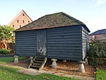 |
| Granary at Little Mascal Farm | Cocksure Lane, North Cray | Granary | Early 19th century | 25 October 1985 | TQ 49197 72154 | 1064210 | Upload Photo |
| High Street House | 123 Bexley High Street, Bexley | House | 1761 | 1 October 1953 | TQ 49730 73491 | 1064245 | 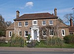 |
| Jays Cottages | 1, 2, and 2A Blendon Road, Bexley | Houses | Late 18th or early 19th century | 17 December 1980 | TQ 47589 74249 | 1064249 | 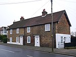 |
| K6 telephone kiosk | Bexley High Street, Bexley | Telephone booth | 1936 | 13 July 1987 | TQ 49416 73544 | 1064214 |  |
| The King's Head Inn | 65 Bexley High Street, Bexley | Pub | 16th or early 17th century | 1 October 1953 | TQ4951373622 51°26′31″N0°09′00″E / 51.441863°N 0.149894°E | 1064244 | 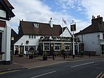 |
| Lamorbey Park [note 4] | Burnt Oak Lane, Sidcup | House | 25 August 1954 | TQ 46585 73138 | 1359405 |  | |
| Large Barn at Howbury Farm | Whitehall Lane, North End | Barn | Early 17th century | 20 May 1952 | TQ 52725 76701 | 1064207 |  |
| Lodge to Hurstmere School | 189 Hurst Road, Sidcup | School | Late 19th century | 17 December 1980 | TQ 47089 73064 | 1188388 |  |
| The Long Shed (part of David Evans Limited Factory at Number 7) | London Road, Crayford | Agricultural building | Probably 18th century | 24 June 1980 | TQ 51103 74779 | 1359413 |  |
| Loring Hall | 8 Water Lane, North Cray | House | c.1760 | 25 August 1954 | TQ 48816 72381 | 1359399 | 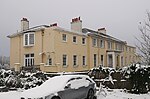 |
| Lychgate to south west of Parish Church of St Mary the Virgin | Manor Road, Bexley | Gate | Late 19th century | 17 December 1980 | TQ 49769 73422 | 1064232 |  |
| Lychgate to west of Parish Church of St Paulinus | Perry Street, Crayford | Gate | Late 19th century | 17 December 1980 | TQ 51143 75108 | 1064200 |  |
| The Manor House | Manor Road, Bexley | House | c.1536 | 17 December 1980 | TQ4984773485 | 1294730 |  |
| Manor House | The Green, Sidcup | House | Late 18th century | 25 August 1954 | TQ 46257 71565 | 1064229 | 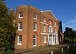 |
| Milestone on pavement slightly to south of axis of Numbers 494 | Footscray Road, Longlands | Milestone | 18th century | 8 June 1973 | TQ 44431 72575 | 1358949 | 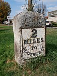 |
| North Cray War Memorial | St James Church, North Cray Road, North Cray | War memorial | 1920 | 3 July 2017 | TQ4842971761 | 1444904 |  |
| The Old House | 170 Rectory Lane, Foots Cray | House | Early 19th century | 25 August 1954 | TQ 47398 71034 | 1359396 | 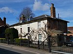 |
| One Bell Public House | 170 Old Road, Crayford, London DA1 4DY | Pub | 18th century | 17 December 1980 | TQ 51243 74991 51°27′13″N0°10′31″E / 51.45374°N 0.175388°E | 1064198 | 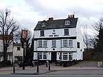 |
| Orchard House | 62 Woolwich Road, Bexleyheath DA7 4HU | House | Early to mid-19th century | 17 December 1980 | TQ 49192 75460 | 1294681 |  |
| Original building of former Bexley National Schools | Bourne Road, Bexley | School | 1834 | 30 August 1974 | TQ 49605 73885 | 1188284 |  |
| Outhouse to north east of Red House | Red House Lane, Bexleyheath | Outhouse | 1859 | 17 December 1980 | TQ 48146 75136 | 1064204 |  |
| Parish Church of All Saints | Nuxley Road, Belvedere | Church | 1853 | 17 December 1980 | TQ 49256 78289 | 1064197 |  |
| Parish Church of St James | North Cray Road, North Cray | Church | 1637–1871 | 17 December 1980 | TQ 48406 71755 | 1064238 |  |
| Parish Church of St John the Evangelist | Parkhill Road, Bexley | Church | 1882 | 17 December 1980 | TQ 49088 73667 | 1064199 |  |
| Parish Church of St John the Evangelist | Church Avenue, Sidcup | Church | 1901 | 17 December 1980 | TQ 46454 71558 | 1064222 |  |
| Pillar box beside Number 48 at junction with Parkhurst Road | Parkhill Road, Bexley | Pillar box | c. 1872–1879 | 17 December 1980 | TQ 49068 73716 | 1359433 |  |
| Place Cottage | The Green, Sidcup | House | Late 16th or 17th century | 17 December 1980 | TQ 46411 71518 | 1188375 |  |
| Post on land of Gun Club, on east side of lane which forms the west boundary of the shooting ground and the west boundary of the former Borough of Dartford | East Rochester Way, Bexley | Coal tax post | Mid-19th century | 25 September 1975 | TQ 51198 73966 | 1336368 |  |
| The Railway Tavern | Bexley High Street, Bexley | Pub | 18th century | 17 December 1980 | TQ 49440 73557 | 1359379 |  |
| The Royal Oak Public House | Mount Road, Bexleyheath | Pub | 19th century | 17 December 1980 | TQ4783574818 51°27′09″N0°07′40″E / 51.452534°N 0.127912°E | 1064234 |  |
| Ruins of Lesnes Abbey | Abbey Road, Abbey Wood | Abbey | 1178 | 20 May 1953 | TQ 47925 78765 | 1359415 |  |
| The Seven Stars Public House | Foots Cray High Street, Foots Cray | Pub | c. 16th century | 5 March 1974 | TQ 47511 70910 | 1359410 |  |
| Sheffield Monument (in churchyard of Parish Church of St John the Evangelist) | Church Avenue, Sidcup | Funerary monument | 1899 | 17 December 1980 | TQ 46493 71545 | 1359407 |  |
| Sidcup Place (including ha ha to east) | Chislehurst Road, Sidcup | House | 1750 | 14 December 1995 | TQ 46229 71309 | 1117384 |  |
| Stable block to former Foots Cray Place | Rectory Lane, Foots Cray | Stable | c.1756 | 25 August 1954 | TQ 47451 71721 | 1359435 |  |
| Street wall and gateway to north of Red House | Red House Lane, Bexleyheath | Wall | 1859 | 17 December 1980 | TQ 48091 75124 | 1294702 |  |
| Styleman's Almshouses | 13–35 Bexley High Street, Bexley | Houses | 1755 | 1 October 1953 | TQ 49351 73602 | 1064243 |  |
| Tomb of Frances Madocks to south side of Parish Church of St James | North Cray Road, North Cray | Tomb | 1790 | 17 December 1980 | TQ 48409 71742 | 1064239 |  |
| Tudor Cottages | Foots Cray High Street, Foots Cray | Houses | Late 15th or early 16th century | 17 December 1980 | TQ 47422 70917 | 1188354 |  |
| Two chest tombs to east side of Parish Church of St James | North Cray Road, North Cray | Tombs | 1728 and 1827 | 17 December 1980 | TQ 48426 71756 | 1188479 |  |
| The x-ray department, formerly the Underground Hospital, Erith and District Hospital | Erith | Hospital | 1938 | 27 November 2003 | TQ 50545 77503 | 1393267 | 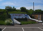 |
| Wall fronting grounds formerly belonging to Bexley House (demolished) | Bourne Road, Crayford | Walls | 18th century | 24 June 1980 | TQ 51028 74766 | 1359382 | 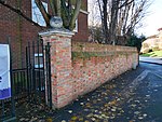 |
| Walls, gatepiers and gates to south of Frognal House | Frognal Avenue, Sidcup | Walls | Early 18th century | 17 December 1980 | TQ 46433 70754 | 1294778 | |
| Walls, gate piers and gates to south of stable block at former Foots Cray Place | Rectory Lane, Foots Cray | Walls | 18th century | 17 December 1980 | TQ 47434 71650 | 1064201 |  |
| Walls surrounding and to west and south west of Parish Church of St James and gatepiers and gates to west of church | North Cray Road, North Cray | Walls | Mid-18th century | 17 December 1980 | TQ 48385 71759 | 1359414 |  |
| Walnut Tree Cottage | 164 Sidcup Hill, Foots Cray | House | Early 17th century | 13 October 1986 | TQ 47230 71071 | 1064212 |  |
| Whitehill House | 1 Crayford Road, Crayford | House | Late 18th–early 19th century | 20 May 1952 | TQ 52336 74483 | 1064224 |  |
| Workshop range to south east of Main Engine House | Belvedere Road, Belvedere | Industrial building | May 1865 | 3 January 1990 | TQ 48528 81013 | 1064216 |  |
| Workshop range to south west of Main Engine House | Belvedere Road, Belvedere | Industrial building | May 1865 | 3 January 1990 | TQ 48423 81072 | 1250557 | |
| World War II heavy anti-aircraft (HAA) battery | Wallhouse Road, Slade Green | Battery | Late 1930s | 2 December 2009 | TQ 52978 77464 | 1393580 |  |
| Wye Lodge | 80 Lion Road, Bexleyheath | House | 17th century | 17 December 1980 | TQ 48505 74932 | 1064231 | 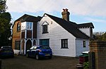 |