Longlands

Last updated

Longlands
Greater London UK location map 2.svg
Red pog.svg
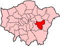
Longlands
Location within Greater London
Population10,442 (2011 Census. Ward) [1]
OS grid reference TQ449722
London borough
Ceremonial county Greater London
Region
Country England
Sovereign state United Kingdom
Post town SIDCUP
Postcode district DA14, DA15
Post town LONDON
Postcode district SE9
Dialling code 020
Police Metropolitan
Fire London
Ambulance London
UK Parliament
London Assembly
List of places
UK
England
London
51°25′49″N0°05′07″E / 51.4302°N 0.0854°E / 51.4302; 0.0854
Longlands ward (green) within the London Borough of Bexley (yellow) Longlands ward.PNG
Longlands ward (green) within the London Borough of Bexley (yellow)

Longlands is an area of South East London that straddles the boundary of both the London Borough of Bexley and the Royal Borough of Greenwich. It lies north west of Sidcup and south east of Eltham.

Contents

Some old maps and records have the name as two words "Long Lands", and show it was in the Foots Cray/Sidcup parish [2] in the Hundred of Ruxley. [3]

Found within Longlands

An 18th-century milestone, now Grade II listed, along Footscray Road in Longlands Southwest Face of the Footscray Road Milestone (I).jpg
An 18th-century milestone, now Grade II listed, along Footscray Road in Longlands

On Main Road there are a small number of shops including: two showrooms, an off license/convenience store, a fish and chip shop, a restaurant, a launderette and a small post office. Shops here seem to be somewhat over shadowed by nearby larger towns, New Eltham and especially Sidcup. Within Longlands the place gives it name to Longlands Recreation Ground, Longlands Primary School, Longlands Road and Longlands Park Crescent. Also things found within the ward of Longlands include Queen Mary's Hospital, Frognal Corner Roundabout, Sidcup Fire Station, Sidcup Place, two primary schools, Longlands primary school and Dulverton Primary School, one secondary school, St Mary and St Joseph's Catholic School, and a small college. These are all part of the Sidcup post town, with the exception of Dulverton Primary School which occupies the small westerly part of the ward that overlaps into the SE9 Postcode district, that is within the London post town. The small river Wyncham Stream also flows from Chislehurst northward through Longlands toward Lamorbey and finally into the River Shuttle.

Transport

Rail

The closest National Rail stations to Longlands are New Eltham and Sidcup.

Buses

Longlands is served by two Transport for London bus services.

Roads

Two A roads pass through Longlands, the A20 "Sidcup By-Pass Road", a dual carriageway, which runs from New Cross until it joins the M20 in Swanley, and the A211 called "Foots Cray Road" and "Main Road". They both run from northwest to southeast, the A20 being the southernmost; on both these roads Longlands sits between New Eltham and Sidcup. An odd fact about the area is these A roads begin some distance apart, come closer together, they then run parallel for a short length at Longlands but move apart again without ever directly meeting; This makes the area recognizable on a map. A large concrete wall stands here separating the roads as they run parallel.

Related Research Articles

<span class="mw-page-title-main">Sidcup</span> Human settlement in England

Sidcup is an area of south-east London, England, primarily in the London Borough of Bexley. It is 11.3 miles (18.2 km) south-east of Charing Cross, bordering the London Boroughs of Bromley and Greenwich. It was part of Kent prior to the creation of Greater London in 1965.

<span class="mw-page-title-main">London Borough of Bexley</span> London borough in United Kingdom

The London Borough of Bexley is a London borough in south-east London, forming part of Outer London. It has a population of 248,287. The main settlements are Sidcup, Erith, Bexleyheath, Crayford, Welling and Old Bexley. The London Borough of Bexley is within the Thames Gateway, an area designated as a national priority for urban regeneration. The local authority is Bexley London Borough Council.

<span class="mw-page-title-main">A20 road (England)</span> Road in England

The A20 is a major road in south-east England, carrying traffic from London to Dover in Kent. Parts of the route date back to turnpikes established in the early part of the 18th century. The line of the road throughout Kent runs closely in parallel with the M20 motorway.

<span class="mw-page-title-main">Bexley</span> Human settlement in England

Bexley is an area of south-eastern Greater London, England and part of the London Borough of Bexley. It is sometimes known as Bexley Village or Old Bexley to differentiate the area from the wider borough. It is located 13 miles (21 km) east-southeast of Charing Cross and south of Bexleyheath.

<span class="mw-page-title-main">Eltham</span> District of southeast London, England

Eltham is a district of southeast London, England, within the Royal Borough of Greenwich. It is 8.7 miles (14.0 km) east-southeast of Charing Cross, and is identified in the London Plan as one of 35 major centres in Greater London. The three wards of Eltham North, South and West have a total population of 35,459. 88,000 people live in Eltham.

<span class="mw-page-title-main">Foots Cray</span> Human settlement in England

Foots Cray is an area of South East London, England, within the London Borough of Bexley. Prior to 1965 it was in the historic county of Kent. It is located south-east of Sidcup, north of Orpington and north west of Swanley.

<span class="mw-page-title-main">River Shuttle</span>

The River Shuttle is a small tributary of the River Cray in London, United Kingdom.

<span class="mw-page-title-main">Swanley</span> Town in Kent, England

Swanley is a town and civil parish in the Sevenoaks District of Kent, England, 16 miles (26 km) southeast of central London, adjacent to the Greater London boundary and within the M25 motorway periphery. The population at the 2021 census was 17,826.

<span class="mw-page-title-main">New Eltham</span> Human settlement in England

New Eltham is a suburban area of South East London, England, primarily in the Royal Borough of Greenwich with some parts in the London Borough of Bexley. It is located south east of Eltham and north west of Sidcup.

<span class="mw-page-title-main">Old Bexley and Sidcup (UK Parliament constituency)</span> Parliamentary constituency in the United Kingdom, 1983 onwards

Old Bexley and Sidcup is a constituency in Greater London represented in the House of Commons of the UK Parliament since its 1983 creation. Its first Member of Parliament (MP) was former Prime Minister Edward Heath, who previously represented Bexley (1950–1974) and Sidcup (1974–1983). The seat has been held since a 2021 by-election by Louie French of the Conservative Party, following the death of incumbent James Brokenshire.

<span class="mw-page-title-main">Albany Park, Bexley</span> Human settlement in England

Albany Park is an area in south east London, England, within the London Borough of Bexley. It is located 12.0 miles (19 km) south east of Charing Cross. Located midway between Sidcup and Bexley, Albany Park is situated on high ground overlooking the valleys of the River Cray and the River Shuttle.

<span class="mw-page-title-main">Blackfen</span> Human settlement in England

Blackfen is an area of South East London, England, within the London Borough of Bexley. It is located north of Sidcup and south of Welling. Prior to the creation of Greater London in 1965 it was in the historic county of Kent.

The London Borough of Bexley owns and maintains over 100 parks and open spaces within its boundaries, with a total of 638 hectares. They include small gardens, river and woodland areas, and large parks with many sporting and other facilities.

St Paul's Cray is an area of South East London, England, within the London Borough of Bromley in Greater London. Prior to 1965 it was within the historic county of Kent. It is located south of Sidcup and north of Orpington.

<span class="mw-page-title-main">Wyncham Stream</span> River in Greater London, England

Wyncham Stream is a small river within the London Boroughs of Bexley and Bromley in southeast London, England, United Kingdom. It is 5.6 km (3.5 mi) in length and is a tributary of the River Shuttle.

Ruxley is a rural settlement of South East London, England that straddles the boundary of the London Boroughs of Bromley and Bexley. It is located 13 miles southeast of Charing Cross, the traditional centre of London, in the Metropolitan Green Belt between Sidcup and Swanley and is also adjacent to the Greater London border with the county of Kent.

<span class="mw-page-title-main">Foots Cray Meadows</span>

Foots Cray Meadows is an area of parkland and woodland 97 hectares in size, within the London Borough of Bexley, England. It borders the suburbs of Albany Park, Sidcup, Foots Cray, North Cray and Ruxley. The River Cray runs through it in a north-easterly direction. The London Loop, a public recreational walking path around London, also known as the "M25 for walkers", runs through the meadows parallel to the river from Sidcup Place, just south of the meadows. Two notable bridges cross the River Cray in the meadows: Five Arches bridge and the smaller Penny Farthing Bridge.

<span class="mw-page-title-main">North Cray</span> Human settlement in England

North Cray is an area in South East London, England, within the London Borough of Bexley. It is located east of Sidcup and south of Bexleyheath and is 12.6 miles (20.3 km) south-east of Charing Cross, the traditional centre of London in the Metropolitan Green Belt.

<span class="mw-page-title-main">Horn Park</span> Area of south east London

Horn Park is an area of south east London south west of Eltham. It is located 12.5 km (7.8 mi) southeast of Charing Cross on the southwest edge of the Royal Borough of Greenwich and borders both the London Borough of Lewisham and the London Borough of Bromley. There is a public park also named Horn Park and two schools in the area. The River Quaggy flows northward though Horn Park, and the suburb is covered by the postcode district SE12, which was previously called the Lee postal district. There is community centre located in Horn Park Estate on Sibthorpe Road, that hosts a number of activities, such as Christian, council and MP meetings, and numerous classes including dance, karate and English.

<span class="mw-page-title-main">St Botolph's Church, Ruxley</span> Church in London Borough of Bromley, United Kingdom

St Botolph's Church is a church building in Ruxley, in the London Borough of Bromley, southeast London, England. It was constructed in the thirteenth century and dedicted to Botwulf of Thorney. St Botolph's was used as a church for around 300 years but was deconsecrated in 1557. The church was then used a farm building for over 400 years and the remains of an oast house are still adjacent to it. In the 1960s archaeological work was carried out on the site and found evidence of an older wooden building, suggesting there may have been an older Saxon church in the same location. Today the church is a Grade II listed building and a scheduled ancient monument on the grounds of Ruxley Manor Garden Centre, although many features are still intact, the church is in disrepair and English Heritage have agreed to pay a grant to help preserve the building.

References

  1. "Bexley Ward population 2011". Neighbourhood Statistics. Office for National Statistics. Retrieved 14 October 2016.
  2. Map of Sidcup parish [ permanent dead link ] from Vision of Britain.org.uk
  3. Old map showing Long Lands (bottom right) in the Hundred of Ruxley. From British History Online