Coney Hall

Last updated

Coney Hall
Greater London UK location map 2.svg
Red pog.svg
Coney Hall
Location within Greater London
OS grid reference TQ394653
London borough
Ceremonial county Greater London
Region
Country England
Sovereign state United Kingdom
Post town WEST WICKHAM
Postcode district BR4
Dialling code 020
Police Metropolitan
Fire London
Ambulance London
London Assembly
List of places
UK
England
London
51°22′12″N0°00′06″E / 51.3699°N 0.0016°E / 51.3699; 0.0016
The main shopping district on Glebe Way. Coney Hall BR4 - geograph.org.uk - 44171.jpg
The main shopping district on Glebe Way.

Coney Hall is an area of Greater London, within the London Borough of Bromley, Greater London and formerly in the historic county of Kent. It is located south of Hayes, west of Keston, north of Nash, and east of West Wickham of which it is usually considered a part. The Prime Meridian passes through Coney Hall. [1]

Contents

History

Coney Hall Farm was first mentioned in the 17th century, when its lease stated that the tenant had the sole right to catch coneys (rabbits) on nearby Jackson’s Heath. [2] [1]

Coney Hall is one of many owner-occupied estates arising during the inter-War housing boom; it was built in the 1930s on hilly farmland south-east of West Wickham by the developers Morrell Brothers, who purchased Coney Hall Farm following the death of its owner Sir Henry Lennard in 1928. [1] In the previous decade, Lennard's opposition to road developments adjacent to West Wickham Common and Hayes Common had left the area accessible only by steep and narrow lanes. [1] In Coney Hall's early days London Transport refused to provide a bus service, and a free private coach service connected the estate to the nearest railway station, Hayes. [1] The quality of the new houses was not always that high, with a mortgage strike by Elsy Borders of 81 Kingsway in 1937 sparking sympathy strikes elsewhere, and contributing ultimately to an improvement in the legal standing of mortgage payers. [1] [3] [4] During World War II Canadian troops were billeted at Coney Hall. [1]

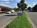
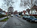
The area contains typical suburban architecture of two-storey houses with polygonal bay windows and half-timbered gables. It is centred on a bend on Glebe Road, east of Coney Hall roundabout, with a smaller row of shops on Addington Road.

Transport

Rail

The nearest National Rail station is Hayes station.

Buses

Public spaces and sport

The local football club - Coney Hall FC - formed in 1973 and reached the Combined Counties League, winning the Division One championship in 2004/05. The club folded in 2016, [9] but a new Coney Hall FC was subsequently formed to play youth football. [10]

Layhams Road runs south from Coney Hall towards the North Downs, and is a popular cycling route. [11]

Related Research Articles

<span class="mw-page-title-main">Tramlink</span> Light rail tram system in South London

Tramlink, previously Croydon Tramlink and presently branded as London Trams, is a light rail tram system serving Croydon and surrounding areas in South London, England. It is the first operational tram system serving the London region since 1952. Tramlink is presently managed by London Trams, a public body part of Transport for London (TfL), and has been operated by FirstGroup since 2017. It is one of two light rail networks in Greater London, the other being the Docklands Light Railway. Tramlink is the fourth-busiest light rail network in the UK behind the Docklands Light Railway, Manchester Metrolink and Tyne and Wear Metro.

<span class="mw-page-title-main">Addington, London</span> Human settlement in England

Addington is a village and area in south London, England, within the London Borough of Croydon. It is south of Spring Park, west of Coney Hall, north of New Addington and east of Forestdale and Selsdon, and is 11.1 miles (18 km) south of Charing Cross and 4 miles (6.4 km) south-east of the centre of Croydon.

Elmstead is a residential district in south-east London, England, within the London Borough of Bromley. It is located north-east of Bromley.

<span class="mw-page-title-main">Keston</span> Human settlement in England

Keston is a village in Greater London, England, located within the London Borough of Bromley, Greater London. Prior to 1965 it was within the historic county of Kent. It is part suburban, part rural in nature and lies on the edge of Hayes Common, just beyond the London conurbation to the south of Bromley Common. It includes the small hamlet of Nash to the southwest. The northern, more suburban part of Keston is sometimes referred to as Keston Mark.

<span class="mw-page-title-main">London Borough of Bromley</span> London borough in United Kingdom

The London Borough of Bromley is a borough in London, England. It borders the county of Kent, of which it formed part of until 1965. The borough's population in the 2021 census was 329,991. It is named after Bromley, its principal district. Other districts are Penge, Hayes, West Wickham, Chislehurst, Beckenham and Orpington. The local authority is Bromley London Borough Council.

<span class="mw-page-title-main">Bromley</span> Area of Greater London

Bromley is a large town in Greater London, England, within the London Borough of Bromley. It is 9+12 miles southeast of Charing Cross, and had an estimated population of 88,000 as of 2023.

<span class="mw-page-title-main">Hayes, Bromley</span> Human settlement in England

Hayes is a suburban area of southeast London, England and part of the London Borough of Bromley. It is located 11 miles (18 km) south-east of Charing Cross, to the north of Keston and Coney Hall, west of Bromley Common, south of Bromley town centre, and east of West Wickham. An ancient parish in the county of Kent, Hayes was within the Orpington Urban District that became part of Greater London in 1965.

<span class="mw-page-title-main">Metrobus (South East England)</span> Bus operator in South-East England

Brighton & Hove Bus and Coach Company Limited, trading as Metrobus, is a bus operator with routes in parts of Surrey, Kent, Sussex, and Greater London. Formed through a management buyout in 1983, Metrobus was purchased by the Go-Ahead Group in September 1999 and is now under the control of Brighton & Hove, part of the Go-Ahead Group.

<span class="mw-page-title-main">West Wickham</span> Area of south-east London, England

West Wickham is an area of South East London, England, in the London Borough of Bromley. It lies south of Park Langley, Eden Park Beckenham and Bromley town center, west of Hayes and north of Coney Hall, east of Spring Park and Shirley. 10.3 miles (16.6 km) south-east of Charing Cross on the line of a Roman road, the London to Lewes Way. Before the creation of Greater London in 1965, West Wickham was in Kent.

<span class="mw-page-title-main">Eden Park railway station</span> National Rail station in London, England

Eden Park railway station serves Eden Park in the London Borough of Bromley in south east London, in Travelcard Zone 5. It is therefore possible to use an Oyster card at the station. It is 12 miles 34 chains (20.0 km) down the line from London Charing Cross. The station and all trains serving it is operated by Southeastern on the Hayes line. The trains are electric, powered by a third rail.

<span class="mw-page-title-main">St Mary Cray</span> Human settlement in England

St Mary Cray is an area of South East London, England, within the London Borough of Bromley. Historically it was a market town in the county of Kent. It is located north of Orpington, and 13 miles (21 km) south-east of Charing Cross.

<span class="mw-page-title-main">A2022 road</span> Road in south London and northern Surrey

The A2022 is a non-primary road in England. It runs south-west into the foothills of the North Downs from West Wickham in the London Borough of Bromley through Selsdon, Sanderstead, Addington, Purley, the Woodcote part of that town, Banstead in Surrey and Epsom Downs through which it descends to a similar altitude as at its beginning to end at Epsom.

<span class="mw-page-title-main">Sundridge, London</span> Human settlement in England

Sundridge Park, also known simply as Sundridge, is an area of Greater London within the London Borough of Bromley and prior to 1965 it was in the historic county of Kent. It is situated north of Bromley, north-west of Widmore and Bickley, south of Grove Park and south-east of Downham. In the twentieth century Sundridge names began to overlap somewhat with neighbouring Plaistow, for example, the main Sundridge shopping parade by the station sits directly east of Plaistow Green, with business and facilities in the area using the two names interchangeably, and Plaistow Cemetery is actually on the Sundridge side of the border. However, during the early twenty first century there have been deliberate attempts to re-establish the separate identities of both villages, Sundridge has its own village sign, and representation has been made to the local council for a village sign for Plaistow. Plaistow refers especially to the area north of Sundridge Park station along Burnt Ash Lane, part of the A2212 road which runs north to south between Grove Park and Bromley.

Ernest Newton was an English architect, President of Royal Institute of British Architects and founding member of the Art Workers' Guild.

<span class="mw-page-title-main">Hayes Common</span>

Hayes Common is a 79-Hectare area of public open land in Hayes in the London Borough of Bromley. It is owned and managed by Bromley Council. It is Site of Metropolitan Importance for Nature Conservation, and a small area is part of the Keston and Hayes Commons Site of Special Scientific Interest. The common is an area of woodland and heath, crossed by bridleways and footpaths. Hayes Common is one of the largest areas of common land in Greater London, with 91.1 hectares of protected commons.

<span class="mw-page-title-main">Kemp & Tasker</span>

Leslie H. Kemp and Frederick E. Tasker were English architects who practiced in the 1930s as Kemp & Tasker.

<span class="mw-page-title-main">Park Langley</span> Human settlement in England

Park Langley is a suburb of South-East London, located in the London Borough of Bromley, Greater London and prior to 1965, in the historic county of Kent. It borders Shortlands and Beckenham to the north, Bromley to the east, Hayes and West Wickham to the south, and Eden Park to the west.

<span class="mw-page-title-main">Mid-Kent line</span> Railway line in the UK

The Mid-Kent line is a British railway line running from Courthill Loop North junction to Hayes railway station in the London Borough of Bromley. Despite its name, none of the line is in the present-day county of Kent.

<span class="mw-page-title-main">Romano-British site, Wickham Court Farm</span> Archaeological site in Bromley, London

The Romano-British site, Wickham Court Farm is a Roman-era archaeological site in the London Borough of Bromley, situated south-east of West Wickham and south-west of Coney Hall. It is a Scheduled Ancient Monument.

References

  1. 1 2 3 4 5 6 7 Willey, Russ. Chambers London Gazetteer, pgs 115-16
  2. "Coney Hall - Hidden London". hidden-london.com. Retrieved 27 March 2017.
  3. McCulloch, Andrew (6 June 2001). "The Mortgage Strikes". History Today. Retrieved 21 March 2020.
  4. Jackson, Alan A. (12 January 2018). Semi-Detached London: Suburban Development, Life and Transport, 1900-39. Routledge. ISBN   978-1-351-17512-8.
  5. "Assembly Halls - West Wickham".
  6. "Guide to Coney Hall Skatepark". The Skateparks Project. 9 September 2018. Retrieved 18 December 2018.
  7. "Coney Hall Recreation Ground | London Borough of Bromley". Archived from the original on 17 June 2014. Retrieved 27 March 2014.
  8. "Well Wood | Explore woods | The Woodland Trust". www.woodlandtrust.org.uk. Retrieved 18 December 2018.
  9. @ConeyFc (19 March 2016). "Unfortunately we have folded due to constant struggles with players/numbers! Best of luck to the rest of the league for the season.😟😟" (Tweet) via Twitter.
  10. "Coney Hall FC" . Retrieved 9 April 2020.
  11. Road Cycling UK https://roadcyclinguk.com/blogs/georges-blog/just-a-perfect-day.html