Mottingham

Last updated

Mottingham
  • The Mott
Village
Mottingham Road - geograph.org.uk - 3860589.jpg
Mottingham Road, the main road through the village
Greater London UK location map 2.svg
Red pog.svg
Mottingham
Location within Greater London
Population11,488 (2021 Census. Mottingham and Chislehurst North Ward) [1]
OS grid reference TQ415725
  Charing Cross 9 mi (14.5 km)  NW
London borough
Ceremonial county Greater London
Region
Country England
Sovereign state United Kingdom
Post town LONDON
Postcode district SE9
Dialling code 020
Police Metropolitan
Fire London
Ambulance London
UK Parliament
London Assembly
List of places
UK
England
London
51°26′01″N0°02′11″E / 51.4337°N 0.0365°E / 51.4337; 0.0365

Mottingham is a district of south-east London, England, which straddles the border of both the London Borough of Bromley and the Royal Borough of Greenwich. It is located south west of Eltham, 1.5 miles (2 kilometres). It was historically within the county of Kent.

Contents

History

Toponymy

The earliest records of Mottingham are from 862 AD during the Anglo-Saxon era when it was recorded as Modingahema, which means the land of Moda's people and is commonly interpreted as "the proud place". In William Henry Ireland's 1830 work England's Topographer: Or A New and Complete History of the County of Kent Volume 4, [2] he writes

Mottingham is a hamlet, lying partly in this parish (referring to Eltham), and partly in that of Chislehurst, at about a mile southward from Eltham church. It was anciently called Modingham, from the Saxon words modig, proud or lofty, and ham, a dwelling. In King Edward the Confessor's confirmation of the gift of Elthruda, King Alfred's niece, of the manor of Lewisham and its appendages, to the abbey of St. Peter's, at Ghent, in Flanders, in 1044, Modingsham is mentioned as one of them belonging to that manor; but the succeeding grants of Lewisham manor make no mention of this place. In the reign of Edward I., it passed as an appendage to the manor of Eltham, in the grant made by that king to John de Vesci; since, which, it has always been considered as part of the same, which at this time claims over the whole of this hamlet. The bounds and extent of the hamlet of Modyngham are thus described in an ancient MS. remaining among registers of the bishop of Rochester:

Memorandum, That the lordship of Modyngham begins at Readhilde, and extends to the wood of the lord bishop called Elmystediswood, towards the south; and to the field, called Charlesfield, towards the west; and to the woods and lands of the king in Eltham, towards the north-east." At the beginning of the reign of King William Rufus, Ansgotus, of Chesilhurst, the king's chamberlain was possessed of the fee of this hamlet, and gave the tithes of it to the priory of St. Andrew's in Rochester. At the beginning of the reign of Edward III., a family of the name of Legh was possessed of certain tenements, with the land and appurtenances belonging thereto, in Modingham and Chesilhurst; from one of that name it passed to Thomas de Bankwell, at whose decease in the 35th year of the same reign, it was found to be possessed of them and held of the king in gavelkind, as one of his manor of Eltham by service of 14s. 11d. per annum rent and performing service to the king's court at Eltham.

In the 14th of Henry VI,. these premises were in the possession of Robert Cheeseman, of Lewisham and East Greenwich, who by marriage with Joane, daughter of Bernard Cavell of Chesilhurst, had considerably increased his property in this place. The family of Cavell was possessed of lands in that part of Modyngham which lies in Chesilhurst, as early as the reign of Edward I., for John Mayo, jun, by his deed in the 18th of Edward I. conveyed several premises in that part of the hamlet to Bernard Cavell sen. of Chesilhurst. The late Cheesman's who held this estate was Thomas Cheesman, whose heir Alice carried it in marriage to Robert Stoddard and his son George Stoddard, and Anne his wife in 1560 built the present mansion-house called Mottingham place, which with the lands belonging thereto, continued in their descendant till Nicholas Stoddard esq., dying in 1765 unmarried and intestate, there appeared many claimants to the inheritance. After a long litigation in the court of Chancery, this seat with the estate was adjudged to an heir by the female line, to William Bowereman esq. of Newport in the Isle of Wight, who passed away his interest therein to Mr. Dyneley, and he nearly rebuilt the seat and resided there. In the old house were the following dates and coats of arms; on the inside of a turret, 1560; on a chimney, 1561; and on an outward gate, 1635.

In the seventeenth century Thomas Fuller recorded in The Worthies of England a curious incident that happened on 4 August 1585:

...in the Hamlet of Mottingham (pertaining to Eltham in this county) in a Field which belongeth to Sir Percival Hart. Betimes in the morning the ground began to sink, so much that three great Elm trees were suddenly swallowed into the Pit; the tops falling downward into the hole; and before ten of the clock they were so overwhelmed, that no part of them might be discovered, the Concave being suddenly filled with Water. The compasse of the hole was about eighty yards, and so profound, that a sounding line of fifty fathoms could hardly find or feel the bottom.

The cause of the incident, referred to as a "marvellous accident" at the time, was then unknown, and it is likely that a sinkhole had developed. The area is well coursed with streams, both above and below ground, and the collapse or shifting of subsoil might be attributed to them. The site of the sinkhole is now unknown, and the incident is also largely unknown. The only body of standing water that is in the area today is a lake at The Tarn Bird Sanctuary.

The eighteenth-century ice well in The Tarn is a Grade II listed structure Southern Side of the Ice Well near the Tarn (I).jpg
The eighteenth-century ice well in The Tarn is a Grade II listed structure

Mottingham was originally a farming hamlet, with a few large houses on Mottingham Lane, one of them Fairy Hall. Development began in the mid-19th century with the building of cottages on what is now Mottingham Road and the Terrace shops. Mottingham station opened in 1866, but was originally named for Eltham. In the 1880s the West Park estate, housing intended for the middle class, was developed and St. Andrew's church was built between the station and the village. [3] [4]

The opening of the Sidcup arterial road in 1923 led to suburban development at Mottingham, with the London County Council creating the Mottingham estate, with 2,000 houses, schools and shops, on Court Farm. The estate opened in 1935. The King and Queen pub, later used as a performance venue, opened in 1937; it was replaced by housing in 1992. [4]

In January 2019, Bromley council approved the borough's Local Plan, a document outlining how and where Bromley will be developed up to 2030. Policy 18 details the commitment to improve the vitality and viability of the Mottingham Local Centre and Kimmeridge Cross Neighbourhood Centre, and to enhance links to other areas of Bromley and adjoining boroughs, particularly in relation to centres of employment. [5]

Local government

Mottingham was originally a hamlet in Eltham parish, in the Blackheath hundred of Kent. In 1840 it was included in the Metropolitan Police District by the Metropolitan Police Act 1839. In 1866, the same year the station was opened, Mottingham was separated from Eltham as a distinct civil parish. [4] [6] In 1881, the parish had a population of 779 and covered an area of 642 acres (260 hectares).

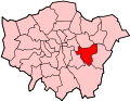
When the County of London was created in 1889, Mottingham was excluded from the new county and formed a protrusion of Kent, bordering London to the west, north and east. From 1894 to 1934, it formed a 'detached part' of Bromley Rural District and had its own parish council. [7] In 1931, the parish had a population of 2,120. In 1934, the rural district and the Mottingham civil parish were abolished and the area was transferred to Chislehurst and Sidcup Urban District. [8] In 1965, the urban district was abolished and the area was transferred from Kent to Greater London, to form part of the London Borough of Bromley. The boundary between Bromley and Greenwich, [9] and between Bromley and Lewisham, [10] around Mottingham was adjusted in 1994. Most of Mottingham is contained within the Mottingham and Chislehurst North ward of Bromley constituency, but the area around Mottingham Station is in the Coldharbour and New Eltham ward of Eltham constituency. [11]

Landmarks

Mottingham war memorial East Face of the Mottingham War Memorial.jpg
Mottingham war memorial

The first church in Mottingham was St Andrew's Church on Court Road, which was established in 1884 and further helped establish Mottingham as separate from Eltham. [3]

Sir Robert Geffrye's almshouses on Mottingham Road were built by the Ironmongers' Company in 1912 to replace the almshouses in Hoxton that are now the Museum of the Home; they were remodelled by the Greater London Council and additional housing built in the grounds. [4]

Martins Bank had a branch in Mottingham village, facing the war memorial; it was the first branch of the bank to undergo an armed raid, in 1967. It became a Barclays following their 1969 takeover of Martins, was closed in 1992. [12]

Also by the war memorial stood the Porcupine Inn public house, licensed as long ago as 1688. The premises dated from about 1800 and were replaced in 1922. The pub closed in 2013 and was acquired by German global discount supermarket chain Lidl, who tried and failed to obtain permission to develop the site. [13] In 2022, Lidl appealed over the head of Bromley Borough and were given permission to clear the site and build their new supermarket. The new store opened for business in April 2023. [14]

Mottingham has a branch of the fraternal order Independent Order of Oddfellows Manchester Unity. [15]

Mottingham village contains a sign depicting Eltham College within the branches of a tree, a cricket bat and ball (making reference to W G Grace) and the date AD 862. [16]

Mottingham and some of its landmarks appear in filmmaker Dewyne Lindsay's mini-documentary series London Districts. [17] [18]

Education

A parade of shops in Mottingham Road Parade of Shops along Mottingham Road (II).jpg
A parade of shops in Mottingham Road

Mottingham Primary School

Age range4–11
GenderMixed
Number of pupils408
School capacity480

[19]

Elmstead Wood Primary School

Age range3–11
GenderMixed
Number of pupils210
School capacity210

[19]

Capel Manor College

Capel Manor College is a specialist environmental college offering land-based further and higher education on a campus that was previously part of Hadlow College. [20]

Eltham College

Eltham College, an independent day school for girls and boys 7–18, founded in 1842 as the London Missionary Society's School for the Sons of Missionaries, has been housed since 1912 in the former Fairy Hall in Mottingham, which had earlier been the Royal Naval School from 1889 to 1910.

Geography

The Tarn is an area of wood and parkland in Mottingham Information Board in the Southwest Area of the Tarn, Mottingham.jpg
The Tarn is an area of wood and parkland in Mottingham

Mottingham borders Eltham to the north, New Eltham to the east, Chislehurst to the south, Elmstead to the south west, Lewisham to the west and Lee to the north west. Since 2010, Mottingham has fallen within the Mottingham and Chislehurst North polling [21] and policing [22] districts.

Quaggy

A tributary of the River Quaggy known as the Little Quaggy flows through Mottingham; rising on the borders of Chislehurst and Mottingham, [23] it flows through The Tarn and emerges alongside the Sidcup bypass to join the Quaggy, which continues to Mottingham playing fields (colloquially known as 'Foxes Field').[ citation needed ]

Mottingham Estate

LCC Cottage estates 1918–1939
Estate nameAreaNo of dwellingsPopulation 1938Population density
Pre-1914
Norbury 1121886719.8 per acre (49/ha)
Old Oak 32736351923 per acre (57/ha)
Totterdown Fields 39126232.4 per acre (80/ha)
Tower Gardens
White Hart Lane
9878359368 per acre (20/ha)
1919–1923
Becontree 277025769 [lower-alpha 1] 1156529.3 per acre (23/ha)
Bellingham 25226731200410.6 per acre (26/ha)
Castelnau 51644285112.6 per acre (31/ha)
Dover House Estate
Roehampton Estate
147121253838.2 per acre (20/ha)
1924–1933
Downham 60070963003211.8 per acre (29/ha)
Mottingham 2022337900911.6 per acre (29/ha)
St Helier 82590683987711 per acre (27/ha)
Watling 38640341911010.5 per acre (26/ha)
Wormholt 68783407811.5 per acre (28/ha)
1934–1939
Chingford [lower-alpha 2] 21715407.1 per acre (18/ha)
Hanwell (Ealing)1401587673211.3 per acre (28/ha)
Headstone Lane 142n.a5000
Kenmore Park 58654207811.3 per acre (28/ha)
Thornhill
(Royal Borough of Greenwich)
21380159818.1 per acre (45/ha)
Whitefoot Lane (Downham)49n.an.a.
  1. Source says 2589 – transcription error
  2. Part of a larger PRC estate around Huntsman Road

Source:

  • Yelling, J. A. (1995). "Banishing London's slums: The interwar cottage estates" (PDF). Transactions. London and Middlesex Archeological Society. 46: 167–173. Retrieved 19 December 2016. Quotes: Rubinstein, 1991, Just like the country.

London County Council bought the Court Farm estate in the early 1930s and planned a 2000 home cottage estate. The first houses were to the west of Mottingham Road and completed in 1935. The estate was fairly self-contained; the community facilities included a shopping centre and several schools.

The British gangster film Piggy was filmed around North Kent, Mottingham and London and one scene was filmed in The Prince of Wales pub on Mottingham Road. [24] African American boxer Frank Craig trained at the Prince of Wales for the bout he ultimately lost to Australian Dan Creedon in 1895. [25]

Coldharbour Estate

In 1946 Woolwich Council built the Coldharbour Estate to the east of Mottingham Road, primarily to provide accommodation for local people made homeless by the Blitz. This completed the use of the LCC land. [26]

Transport

Rail

Mottingham railway station serves the district with Southeastern services to London Charing Cross, London Cannon Street via both Lewisham and Woolwich Arsenal, and Dartford.

Bus

Notable residents

Related Research Articles

<span class="mw-page-title-main">Chislehurst</span> Settlement in South East England

Chislehurst is a suburban district of south-east London, England, in the London Borough of Bromley. It lies east of Bromley, south-west of Sidcup and north-west of Orpington, 10 miles (16 km) south-east of Charing Cross. Before the creation of Greater London in 1965, it was in Kent.

<span class="mw-page-title-main">Sidcup</span> Human settlement in England

Sidcup is an area of south-east London, England, primarily in the London Borough of Bexley. It is 11.3 miles (18.2 km) south-east of Charing Cross, bordering the London Boroughs of Bromley and Greenwich. Before the creation of Greater London in 1965, it was in the historical county of Kent.

<span class="mw-page-title-main">Lewisham</span> Area of London

Lewisham is an area of southeast London, England, six miles south of Charing Cross. It is the principal area of the London Borough of Lewisham, and was within the historic county of Kent until 1889. It is identified in the London Plan as one of 35 major centres in Greater London, with a large shopping centre and street market. Lewisham had a population of 60,573 in 2011.

<span class="mw-page-title-main">Lee, London</span> Human settlement in England

Lee, also known as Lee Green, is an area of South East London, England, straddling the border of the London Borough of Lewisham and the Royal Borough of Greenwich. It is located northwest of Eltham and southeast of Lewisham. Historically it has been part of the historic county of Kent.

<span class="mw-page-title-main">Eltham</span> District of southeast London, England

Eltham is a district of southeast London, England, within the Royal Borough of Greenwich. It is 8.7 miles (14.0 km) east-southeast of Charing Cross, and is identified in the London Plan as one of 35 major centres in Greater London. The three wards of Eltham North, South and West have a total population of 35,459. 88,000 people live in Eltham.

<span class="mw-page-title-main">River Quaggy</span> River in Greater London, England

The River Quaggy is a river, 17 kilometres (11 mi) in length, passing through the south-east London boroughs of Bromley, Greenwich and Lewisham. In its lower reaches it is an urban river, in its upper reaches further from London it is more natural and known as the Kyd Brook. The river rises from two sources near Princess Royal University Hospital (PRUH) at Locksbottom and is a tributary of the River Ravensbourne which it flows into near Lewisham station in Lewisham.

<span class="mw-page-title-main">Grove Park, Lewisham</span> Human settlement in England

Grove Park is a district of South East London, England within the London Borough of Lewisham. It is located north east of Bromley and south east of Lewisham.

<span class="mw-page-title-main">New Eltham</span> Human settlement in England

New Eltham is a suburban area of South East London, England, primarily in the Royal Borough of Greenwich with some parts in the London Borough of Bexley. It is located south east of Eltham and north west of Sidcup.

<span class="mw-page-title-main">Dartford Loop Line</span> Railway line in the UK

The Dartford Loop Line is one of three lines linking London with Dartford in Kent, England. It lies to the south of the other two: the North Kent Line and the Bexleyheath Line.

<span class="mw-page-title-main">Hither Green railway station</span> National Rail station in London, England

Hither Green is a railway station located in Hither Green in the London Borough of Lewisham, south-east London. It is 7 miles 16 chains (11.6 km) down the line from London Charing Cross and is situated between Lewisham and either Grove Park or Lee depending on the route.

<span class="mw-page-title-main">Eltham (UK Parliament constituency)</span> UK Parliament constituency since 1983

Eltham is a constituency in Greater London created in 1983 and represented in the House of Commons of the UK Parliament since 1997 by Clive Efford of the Labour Party.

<span class="mw-page-title-main">Parliamentary constituencies in London</span>

The region of Greater London, including the City of London, is divided into 73 parliamentary constituencies which are sub-classified as borough constituencies, affecting the type of electoral officer and level of expenses permitted.

St Paul's Cray is an area of South East London, England, within the London Borough of Bromley in Greater London. Prior to 1965 it was within the historic county of Kent. It is located south of Sidcup and north of Orpington.

Bromley was a rural district in north-west Kent, England from 1894 to 1934. Its area now forms part of the London Borough of Bromley in Greater London. It did not include the main settlement of the same name, which constituted the Municipal Borough of Bromley. Mottingham formed an exclave of the district.

<span class="mw-page-title-main">Hundred of Blackheath, Kent</span>

Blackheath was an ancient hundred in the north west of the county of Kent in England. It had become obsolete by the beginning of the 20th century in the wake of ongoing reforms to local government. The name "Blackheath" now refers to a district of SE London. In 2022, the area of the old hundred lies mainly within the Royal Borough of Greenwich.

<span class="mw-page-title-main">Horn Park</span> Area of south east London

Horn Park is an area of south east London south west of Eltham. It is located 12.5 km (7.8 mi) southeast of Charing Cross on the southwest edge of the Royal Borough of Greenwich and borders both the London Borough of Lewisham and the London Borough of Bromley. There is a public park also named Horn Park and two schools in the area. The River Quaggy flows northward though Horn Park, and the suburb is covered by the postcode district SE12, which was previously called the Lee postal district. There is community centre located in Horn Park Estate on Sibthorpe Road, that hosts a number of activities, such as Christian, council and MP meetings, and numerous classes including dance, karate and English.

<span class="mw-page-title-main">Well Hall</span> Human settlement in England

Well Hall is a place to the north of Eltham in the Royal Borough of Greenwich in southeast London, England, with no present formal boundaries and located 13.5 km (8.4 mi) east-southeast of Charing Cross. In the past Well Hall was the grounds of a manor house, and then a hamlet. Today it is a largely residential suburb and housing estate absorbed by the development of Eltham and London. It is centred on the main road between Eltham and Woolwich, on which many shops and businesses are located. Several major A roads including the South Circular Road and A2 road pass through the area, as does a railway line, serving Eltham station which is located in Well Hall. The Postcode that covers Well Hall and most of the Eltham area is SE9, and the 020 dialing covers the entire Royal Borough of Greenwich. Well Hall is split across two electoral wards, Eltham West on the west side of Well Hall Road, and Eltham North on the east side of Well Hall Road. In 2015 the population of these two wards combined was recorded as 24,621, although the wards cover a larger area than just Well Hall.

<span class="mw-page-title-main">Coldharbour, Greenwich</span> Area of south east London

Coldharbour is an area of South East London and post-war housing estate within the Royal Borough of Greenwich. It is located to the south of Eltham and north of Chislehurst.

<span class="mw-page-title-main">The Tarn</span> UK nature reserve

The Tarn is a 9 acres (3.6 ha) site on Court Road between Mottingham and Eltham, in the Royal Borough of Greenwich, southeast London, United Kingdom, consisting of a public garden, a bird sanctuary nature reserve and a lake amongst woodland. The woodland and lake, which was historically known as Starbuck's Pond, were previously the southern part of the Great Park, one of three parks belonging to the estate of Eltham Palace and used as a royal deer hunting park for several centuries up until the English Civil War. As a garden The Tarn opened in 1935, after the Metropolitan Borough of Woolwich acquired the site from the adjacent Royal Blackheath Golf Course. The Tarn remains largely unchanged since the 1930s and contains several shelters, benches, a public toilets building and a circular path which crosses a wooden footbridge spanning the lake. There is also an 18th-century ice house in the garden, which is a listed structure.

<span class="mw-page-title-main">Horn Park (park)</span>

Horn Park is a 16 acres (6.5 ha) public park within Horn Park in the Eltham area of the Royal Borough of Greenwich, southeast London, United Kingdom. It has a mixture of grassland and woodland, children's playground, football pitch, outdoor gym and the first skate park in the Royal Borough of Greenwich. Historically Horn Park was one of three deer hunting parks belonging to Eltham Palace, over the centuries it was also used as grazing farmland and a fruit orchard. The park today is some of the last remaining open space of the original park, a public park next to the Horn Park housing estate which was completed just after the Second World War.

References

  1. "Mottingham (Ward, United Kingdom)". citypopulation.de. Retrieved 18 December 2023.
  2. Ireland, William Henry (28 August 2018). "England's Topographer: Or A New and Complete History of the County of Kent; from the Earliest Records to the Present Time, Including Every Modern Improvement. Embellished with a Series of Views from Original Drawings by Geo. Shepherd, H. Gastineau, &c. with Historical, Topographical, Critical, & Biographical Delineations". G. Virtue via Google Books.
  3. 1 2 "Mottingham: St Andrew with St Alban". The Diocese of Southwark.
  4. 1 2 3 4 "Mottingham, Bromley/Greenwich". Hidden London. Retrieved 11 July 2020.
  5. Bromley, London Borough of. "Bromley Local Plan | London Borough of Bromley". www.bromley.gov.uk. Archived from the original on 9 August 2019. Retrieved 11 July 2020.
  6. Vision of Britain - Mottingham CP [ permanent dead link ] (historic map [ permanent dead link ])
  7. Vision of Britain - Bromley RD [ permanent dead link ] (historic map [ permanent dead link ])
  8. Vision of Britain - Chislehurst and Sidcup UD [ permanent dead link ] (historic map [ permanent dead link ])
  9. Office of Public Sector Information - Bromley and Greenwich (London Borough Boundaries) Order 1993
  10. Office of Public Sector Information - Bromley and Lewisham (London Borough Boundaries) Order 1993
  11. "Ward Atlas (2014)". londondatastore-upload.s3.amazonaws.com.
  12. "11-20-60 London Mottingham SE9". Martinsbank.co.uk. Retrieved 11 July 2020.
  13. Leeming, Lachlan (22 May 2020). "Decision on Mottingham's Porcupine pub proposal hooked at the last minute". News Shopper.
  14. News Shopper, 2023-04-14
  15. "The Oddfellows. A friendlier society". The Oddfellows.
  16. Anstiss, David. "Close-up of Mottingham Village Sign". Geograph.org.uk.
  17. Shields, Conor (2 July 2019). "Filmmaker has made 40 mini-docs about London districts". News Shopper.
  18. Archived at Ghostarchive and the Wayback Machine : "London Districts: Mottingham (Documentary)". YouTube. 20 October 2019.
  19. 1 2 Ofsted Communications Team (12 March 2020). "Find an inspection report and registered childcare". reports.ofsted.gov.uk. Archived from the original on 13 September 2018. Retrieved 11 July 2020.
  20. O'Byrne Mulligan, Euan (9 January 2020). "Failing Mottingham further education college taken over". News Shopper.
  21. "Mottingham and Chislehurst North ward polling district map". London Borough of Bromley. Archived from the original on 27 February 2020. Retrieved 11 July 2020.
  22. "Mottingham and Chislehurst North". Metropolitan Police. Retrieved 11 July 2020.[ permanent dead link ]
  23. "Local history: In search of the Quaggy". QWAG: Quaggy Waterways Action Group. Retrieved 11 July 2020.
  24. Jarvis, Nikki (18 May 2012). "Pub regulars go from pork scratchings to Piggy film fame". News Shopper.
  25. "Prince of Wales Pub of Mottingham". Dover Kent Archives. 9 November 2019.
  26. "History of South-East London Suburbs: Mottingham". Ideal Homes. Archived from the original on 16 February 2016. Retrieved 13 January 2016.
  27. "W. G. Grace | Cricketer | Blue Plaques". English Heritage.
  28. "W. G. Grace (1848-1915) cricketer lived here". openplaques.org. Retrieved 13 February 2013.
  29. Gregory, Julia (20 April 2012). "Story of Eltham College sporting star takes to the stage". Bexley Times.
  30. McKie, David (3 October 2015). "Lord Healey obituary". The Guardian . Retrieved 21 November 2020.
  31. Palmer, Jim (5 September 2013). "Mottingham comedian Rob Beckett chats to Vibe ahead of UK tour". News Shopper.
  32. Waggoner, Walter H. (8 March 1984). "Sir John Bertram Adams, 63; Led European Atomic Center". The New York Times.
  33. Crowley-Milling, Michael C. (1994) [1993]. John Bertram Adams, Engineer Extraordinary: A Tribute. Yverdon, Switzerland: Gordon and Breach. pp. 1–2. ISBN   9782881248757.
  34. "Olympic Dreams: Jeffrey Lawal-Balogun running to 2012". BBC Sport. 28 July 2011.
  35. "Chris Beetles Gallery". Chris Beetles. 25 February 1963. Retrieved 11 July 2020.