South Kilburn

Last updated

View of South Kilburn tower blocks South Kilburn Estate - geograph.org.uk - 417246.jpg
View of South Kilburn tower blocks

South Kilburn is a large housing estate in Kilburn, in the London Borough of Brent. [1] [2] Typical of brutalist 1960s designs of public housing in the United Kingdom, it is characterised by high-density housing in low-rise flats and 11 concrete tower blocks. It was approved in 1959 and extended in 1963. This scheme was further developed in the late 1960s and early 1970s; redevelopment occurred during the 2010s. The population is predominantly Afro-Caribbean and Pashtun.

Contents

Geography

South Kilburn is within the London Borough of Brent, to the east/southeast of Queens Park tube station, immediately south of Kilburn Park tube station, north of Maida Hill, and to the west of the Paddington Recreation Ground. Carlton Vale is the numbered street that separates the northern and southern parts of the estate.

Redevelopment

In 2014 a massive redevelopment project was started by the London Borough of Brent to redevelop the estate, starting with the demolition of two of the 18-storey housing blocks on the estate. [3] This has continued with the creation of new housing blocks built to modern design quality and energy efficiency standards and owned by several different housing associations along with infill developments owned by the local council. [4] Per the plans for this regeneration scheme, the redevelopment so far has seen a net loss of social housing units as most of the new blocks replacing the demolished buildings include a number of flats for social rent ("council housing") along with flats for sale on the private market. The Gloucester House and Durham Court section of the regeneration, begun by Telford Homes housing association in 2017, will see the demolition of 209 flats and their replacement with 235 new-build units, nearly half of which (133) will be for private sale. [2] [5] [6] The construction of market-rate flats for sale has made the area popular with real estate investors and home-buyers who see the area's central location and numerous transport links as attractive features. [7]

In May 2019, inhabitants of the newly built Merle Court (opened in 2012) were forced to move due to design problems in the building. [8] Several months later the mandatory balloting procedure of residents for Phase 2 of the South Kilburn redevelopment scheme was met with a campaign by some local residents to extend the ballot to all 8,000 residents, many of whom, in anticipation of future demolition, are settled on the estate as residents in temporary accommodation, and who, Brent Council argues, do not need to be included under the Greater London Authority's rules on estate regeneration balloting. [9]

Crime on the estate

William Dunbar House William Dunbar House, Kilburn.jpg
William Dunbar House

South Kilburn has long been plagued by crime, the streets and blocks that characterise the dense sprawl of housing being the site of numerous shootings and a drug trade controlled by various gangs, including the notorious £R. [1] [10] [11] [12] The gangs of South Kilburn have been known to have an ongoing rivalry with gangs from West Kilburn in particular the Mozart Estate and the Kensal Green boys, which has resulted in numerous shootings, stabbings and kidnappings. [13] [1] [14] [12] The rivalry has been reported to be a typical "postcode war", [15] as South Kilburn is part of NW6 while West Kilburn covers parts of W9, W10 and NW10.

2007 raid

On 18 April 2007, 500 police, including firearms officers, raided the estate in a series of dawn raids after a months-long sting operation where members of a gang known as F.A.C. (Fire Arms Cartel) had been selling guns to undercover police officers. [16] [17] Numerous arrests were made resulting in prosecutions with claims that the police had 'smashed' an 'untouchable gang'. [16] Although crime levels subsequently fell to some extent, there were similar raids in 2011 when 250 police officers once again stormed the South Kilburn Estate in a co-ordinated drugs raid. [18] The gang rivalry between the South Kilburn and Mozart estates has continued with numerous gang fights as well as the shooting of innocent victim Daniel Omari Smith, gunned down in 2010 in a KFC in a case of mistaken identity. [12] [19] [20] In 2013, mother of one Sabrina Moss was killed in a takeaway shop on Kilburn High Road while celebrating her 24th birthday, when she was hit by bullets from a MAC-10 submachine gun, intended for South Kilburn gang members from the F.A.C. gang who were also in the takeaway. [21] [22] Her friend as well as two South Kilburn gang members were also hit by bullets and injured in the attack which was perpetrated by members of the Kensal Green Boys gang who were involved in a long-running feud with gangs from the South Kilburn Estate. [22]

Mohanna Abdhou murder

In May 2017, Mohanna Abdhou, a 20-year-old woman, was shot and killed while hanging out with friends on the South Kilburn Estate outside Dickens House. [23] The intended targets were probably a group of young men from the estate who managed to escape being shot while Mohanna, who had no involvement with gangs, was tragically hit by a bullet in the stomach and died. [23] Once again, this killing was connected by police and prosecutors to the tit-for-tat violence between local gangs in and around the area. [24] The gang war between the Mozart and South Kilburn estates continues despite community and local government action. [25]

The area continues to be affected by its history of gang violence and drug dealing. [26] [27]

Housing corruption

A scheme started by the South Kilburn Partnership to redevelop the estate was accused of corruption in 2010, when £50 million allocated for the estate's redevelopment went missing. [28]

The critically acclaimed novel Who They Was, written by Gabriel Krauze, recounts his life in South Kilburn, and his experiences around the South Kilburn Estate with gangs, drugs and crime. [29] [30]

See also

Related Research Articles

<span class="mw-page-title-main">Brixton</span> District in the London Borough of Lambeth in south London

Brixton is a district in South London, part of the London Borough of Lambeth, England. The area is identified in the London Plan as one of 35 major centres in Greater London. Brixton experienced a rapid rise in population during the 19th century as communications with central London improved.

<span class="mw-page-title-main">Harlesden</span> Human settlement in England

Harlesden is a district in the London Borough of Brent, North West London.

<span class="mw-page-title-main">Hattersley</span> Human settlement in England

Hattersley is an area of Tameside, Greater Manchester, England; it is located 4 miles (6.4 km) west of Glossop and 10 miles (16 km) east of Manchester city centre, at the eastern terminus of the M67. Historically part of Tintwistle Rural District in Cheshire until 1974, it is the site of an overspill estate built by Manchester City Council in the 1960s. Hattersley is an area receiving major regeneration, which includes building new housing and additional retail stores.

<span class="mw-page-title-main">Little London, Leeds</span> Area of Leeds, West Yorkshire, England

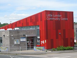
Little London is a residential area of Leeds in England, north of the city centre and Leeds Inner Ring Road. It is so called because in the 19th century it had fashionable housing and interesting architecture comparable to London. In the 1950s and '60s it became largely council housing and now consists of a mixture of high and low-rise flats and housing. The area falls within the Little London and Woodhouse ward of the City of Leeds Council. The area is divided into four estates; Lovell Park, Oatlands, Carlton and the Servias.

<span class="mw-page-title-main">Aylesbury Estate</span> Housing estate in Walworth, London

The Aylesbury Estate is a large housing estate located in Walworth, South East London.

<span class="mw-page-title-main">Broadwater Farm</span> Human settlement in England

Broadwater Farm, often referred to simply as "The Farm", is an area in Tottenham, North London, straddling the River Moselle. The eastern half of the area is dominated by the Broadwater Farm Estate ("BWFE"), an experiment in high-density social housing, loosely based on Corbusian ideas, dominated by concrete towers connected by walkways, built in the late 1960s using cheap but fire-vulnerable pre-fabricated concrete panels. The western half of the area is taken up by Lordship Recreation Ground, one of north London's largest parks. Broadwater Farm in 2011 had a population of 4,844. The estate is owned by Haringey London Borough Council.

<span class="mw-page-title-main">Grahame Park</span> Housing estate in London

Grahame Park, located on the site of the old Hendon Aerodrome in North West London, is a north London housing estate in the London Borough of Barnet, including 1,777 council homes built in the 1970s.

Muirhouse is a housing estate in the north of Edinburgh, the capital of Scotland.

<span class="mw-page-title-main">Stonebridge, London</span> Human settlement in England

Stonebridge is a locality in the London Borough of Brent Stonebridge is situated in southern Brent, on the Harrow Road between Harlesden and Wembley. The 17th and 18th centurie London, England. The A404 runs through the district known locally as Brentfield and Hillside, while to the south are railway tracks and to the west is the North Circular Road along with Stonebridge Park station. The area is known for the previously troubled 1960s Stonebridge housing estate, which was completely redeveloped in the 2010s.

<span class="mw-page-title-main">Loughborough Junction</span> Human settlement in England

Loughborough Junction is an area of South London, in the London Borough of Lambeth, which is located equidistant between Brixton, Camberwell and Herne Hill.

South Acton is an area in Acton, West London, 6.4 miles (10.3 km) west of Charing Cross. At the 2001 census, Acton, comprising the wards of East Acton, Acton Central, South Acton and Southfield, had a population of 53,689 people.

The Peckham Boys, also referred to as Black Gang, is a multi-generational gang based in Peckham, South London. The gang is particularly prominent for its members prolific activity in music. Giggs, once a member of the SN1 set, is generally credited with popularising the British gangsta rap style known as road rap. Giggs would proceed to have a successful musical career, and re-form SN1 as a record label. In 2011, Peckham Boys rapper Stigs was given the first ever gang injunction, banning him from making any music that may encourage violence. Stigs was at the time allegedly a member of Anti GMG. In 2011, Southwark Council identified three sets of the Peckham Boys, PYG, Anti GMG and SN1, as the most active gangs in the Peckham area.

<span class="mw-page-title-main">Heygate Estate</span> Former housing estate in London

The Heygate Estate was a large housing estate in Walworth, Southwark, South London comprising 1,214 homes. The estate was demolished between 2011 and 2014 as part of the urban regeneration of the Elephant & Castle area. Home to more than 3,000 people, it was situated adjacent to Walworth Road and New Kent Road, and immediately east of the Elephant & Castle road intersection. The estate was used extensively as a filming location, due in part to its brutalist architecture.

Church End, commonly known locally as "Church Road", is a small locality in the London Borough of Brent and a sub-district of Willesden. The population is predominantly Afro-Caribbean.

<span class="mw-page-title-main">Chalkhill Estate</span> Public housing project in London UK

Chalkhill Estate is located in the Wembley Park area of North West London. It was originally one of three large council estates built in the London Borough of Brent by the early 1970s, along with Stonebridge and South Kilburn. The design was based on that of Park Hill in Sheffield. The high-rise estate was demolished by 2000 and gradually replaced by new low-rise builds.

<span class="mw-page-title-main">Brent Cross Cricklewood</span>

Brent Cross Cricklewood is a new town centre development under construction in Hendon and Cricklewood, London, United Kingdom. The development is planned to cost around £4.5 billion to construct and will include 6,700 homes, workspace for 25,000 people, four parks, transport improvements and a 592,000 sq ft (55,000 m2) extension of Brent Cross Shopping Centre. The developers of the scheme are Hammerson and Standard Life.

<span class="mw-page-title-main">Carpenters Estate</span> Housing estate in Stratford, London

The Carpenters Estate is located in Stratford, Newham, East London, close to the Queen Elizabeth Olympic Park. The estate is formed of low rise social housing and three tower blocks. The estate has been continually earmarked for demolition and redevelopment.

<span class="mw-page-title-main">Carlton Tavern</span> Pub in Kilburn, London

The Carlton Tavern is a pub in Kilburn, London, originally completed in 1921, that was illegally demolished in 2015 by Tel Aviv-based developer CLTX, which had failed to obtain the necessary planning permission. The Westminster City Council subsequently ordered the pub to be rebuilt. It reopened on 12 April 2021. The pub was the only building in the street to survive the Blitz during World War II.

<span class="mw-page-title-main">Nightingale Estate</span> Housing estate in Lower Clapton, London

The Nightingale Estate is located in the Lower Clapton area of the London Borough of Hackney, next to Hackney Downs. The estate originally consisted of six 22 story tower blocks, but was redeveloped between 2003-2006 and replaced with mostly low-rise buildings. Only one of the towers, Seaton Point, still remains.

<span class="mw-page-title-main">Winstanley and York Road Estate</span> Housing estates in Battersea, London

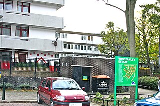
The Winstanley and York Road Estate comprises two large estates of predominantly public housing apartments in Battersea, London, adjacent to Clapham Junction railway station, although some have since passed into private ownership.

References

  1. 1 2 3 Hill, Dave (1 March 2012). "London falling: violence, feuds and fear scar the capital's heart". Theguardian.com. Retrieved 19 May 2019.
  2. 1 2 "Fantastically well-located former 'no-go zone' getting £600m overhaul". Homes and Property. 11 September 2018. Retrieved 19 May 2019.
  3. King, Lorraine (12 March 2014). "South Kilburn says goodbye to two tower blocks as part of £660m regeneration project". Kilburn Times. Retrieved 19 May 2019.
  4. Moore, Rowan (10 July 2016). "South Kilburn estate review – homes that are streets ahead". Theguardian.com. Retrieved 19 May 2019.
  5. Miller, Frederica (7 March 2018). "Everything you need to know about 235 new South Kilburn homes". getwestlondon. Retrieved 22 November 2019.
  6. "South Kilburn | Telford Homes". www.telfordhomes-ir.london. Retrieved 22 November 2019.
  7. "Fantastically well-located former 'no-go zone' getting £600m overhaul". Homes and Property. 11 September 2018. Retrieved 22 November 2019.
  8. Raffray, Nathalie (2 May 2019). "Defects in South Kilburn block results in all occupiers forced to move home". Kilburn Times. Retrieved 22 November 2019.
  9. Raffray, Nathalie (11 October 2019). "Petition launched to stop South Kilburn regeneration ballot so 8,000 others can take part". Kilburn Times. Retrieved 22 November 2019.
  10. "'Be Brave' Plea over Gun Killer; in Brief" - The Evening Standard (London, England), July 19, 2006". Archived from the original on 1 February 2020.
  11. "The Social Affairs Unit - Web Review: The Murder of Toni-Ann Byfield: if future such cases are to be prevented the practice of bringing young children into the UK to be educated / exploited in a welfare-rich country must be challenged, argues Lilian Pizzichini". www.socialaffairsunit.org.uk. Retrieved 19 May 2019.
  12. 1 2 3 Bloom, Ben (7 June 2012). "Innocent Queen's Park electrician was gunned down in revenge for gangland murder of South Kilburn man". Kilburn Times. Retrieved 19 May 2019.
  13. "The Westminster you don't see". Newstatesman.com. Retrieved 19 May 2019.
  14. Young, Kevin (30 September 2011). "'Postcode' wars blighting estate". Bbc.co.uk. Retrieved 19 May 2019.
  15. "London shooting: 'Postcode' wars blight Mozart Estate". BBC News. 30 September 2011.
  16. 1 2 "500 police storm homes to smash gang that terrorised an estate". Evening Standard. 18 April 2007. Retrieved 19 May 2019.
  17. "17 arrests on crime-ridden estate". This Is Local London. Retrieved 19 May 2019.
  18. Ferguson, Kate (18 May 2011). "250 police storm homes in South Kilburn drugs raid". Kilburn Times. Retrieved 19 May 2019.
  19. McMahon, Glenn (8 April 2011). "Estate gangs clash in Kilburn". Kilburn Times. Retrieved 19 May 2019.
  20. "Man in electrician murder charge". Bbc.co.uk. 18 August 2011. Retrieved 19 May 2019.
  21. "Teacher killers jailed for 37 years". Bbc.co.uk. 12 September 2014. Retrieved 19 May 2019.
  22. 1 2 "Pair injured in Sabrina Moss murder allegedly South Kilburn gang members". Kilburn Times. 2 July 2014. Retrieved 19 May 2019.
  23. 1 2 Khomami, Nadia (30 May 2017). "Woman shot dead in Kilburn was innocent bystander, witnesses say". Theguardian.com. Retrieved 19 May 2019.
  24. "Woman killed by stray 'gang war' bullet". Bbc.co.uk. 5 April 2018. Retrieved 19 May 2019.
  25. King, Lorraine (23 December 2011). "South Kilburn teenager arrested in connection with Mozart Estate drive-by shooting". Hampstead Highgate Express. Retrieved 19 May 2019.
  26. Bewley, Hannah (24 January 2013). "Gang arrests made in notorious estate in Kilburn". mylondon. Retrieved 19 May 2019.
  27. King, Lorraine (17 May 2016). "Drugs and deadly weapons found hidden in bushes in South Kilburn". Kilburn Times. Retrieved 19 May 2019.
  28. "Regeneration boss promises to deliver". Kilburn Times. 31 July 2009. Retrieved 19 May 2019.
  29. Rowland Hill, Matt (29 August 2020). "Who They Was by Gabriel Krauze review – the double life of a London gangster". The Guardian . Retrieved 1 June 2021.
  30. Marshall, Alex (27 June 2021). "With a Violent Debut, He Reveals a London That Is Rarely Seen". The New York Times. ISSN   0362-4331 . Retrieved 27 June 2021.

51°31′48″N0°11′49″W / 51.530°N 0.197°W / 51.530; -0.197