Shortlands

Last updated

Shortlands
Shortlands Cenotaph - geograph.org.uk - 1426308.jpg
The Shortlands war memorial
Greater London UK location map 2.svg
Red pog.svg
Shortlands
Location within Greater London
Population9,303 
(ward, 2001 census) [1]
9,824 (2011 Census. Ward) [2]
OS grid reference TQ395685
London borough
Ceremonial county Greater London
Region
Country England
Sovereign state United Kingdom
Post town BROMLEY
Postcode district BR2
Dialling code 020
Police Metropolitan
Fire London
Ambulance London
UK Parliament
London Assembly
List of places
UK
England
London
51°23′54″N0°00′14″E / 51.3983°N 0.0039°E / 51.3983; 0.0039

Shortlands is a suburb of South East London, England, within the London Borough of Bromley. It has been part of Greater London since 1965, and was previously part of the historic county of Kent. It is located between west of Bromley and east of Beckenham.

Contents

History

The earliest known settlement in the area was an Iron Age hillfort at Toots Wood, where traces of a Roman Camp and pottery has also been found. [3] [4] [5] Dr Peter D. Moore has performed a pollen analysis at the site which suggest that the site was abandoned before the beginning of the Roman occupation. [3]

Historically, Shortlands was known as Clay Hill. [6] [5] In medieval times the areas consisted of sets of long and short fields, called Longelonds and Shortelonds, the latter ultimately giving its name to Shortlands House (later converted into a hotel, and now a part of Bishop Challoner School) which was built at the start of the 18th century. [5] The house with its extensive farmland was acquired in 1848 by a railway magnate William Wilkinson, who also built several cottages for his farm labourers. [7] [5] Housing development began in the 1860s with the sale of the Shortlands House estate, spurred by the opening of Shortlands railway station in 1858. [5] The housing along Westmoreland Road largely dates to the 1880s, with further development occurring in the 20th century. [5]

Pearson & Cox was a British automobile manufacturer in Shortlands, trading from 1908 to 1916. In 1913 they manufactured both steam-powered vehicles (cars and bicycles) and petrol powered cyclecars. [8] [9]

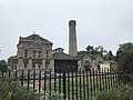
In 1921, a war memorial, designed by W. D. Caroe in the form of a Celtic cross, was unveiled in the village, in the middle of a road junction. On 8 July 2016, a Mini car collided with the memorial, breaking it into pieces. [10] The memorial was restored in October 2017 and re-positioned on its site. [11]

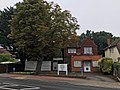
Shortlands is today a quiet, prosperous suburb. There is a library on Shortlands Road and a small row of shops by the railway station.

Transport

Rail

Shortlands station is in Travelcard Zone 4 of Transport for London’s zonal fare system, and serves the area with National Rail services to London Victoria via Herne Hill, as well as Orpington. Shortlands is also served by Thameslink to London Blackfriars via Catford, (during peak hours these trains continue to Luton via St Pancras International); as well as to Sevenoaks via Swanley. As of 2019, the station also houses a coffee shop, snack retailer and dry cleaners.

Buses

Shortlands is served by London Buses routes 162, 227, 354, 358, 367 and N3. These connect it with areas including Beckenham, Bromley, Bromley Common, Locksbottom, Farnborough, Green Street Green, Keston, Park Langley, Eden Park, Chislehurst, Bickley, Eltham, New Eltham, Croydon, Shirley, Addiscombe, Crystal Palace, Elmers End, Anerley, Penge and Orpington.

Route 162, and the N3 night bus between Oxford Circus and Bromley North serve Shortlands via Hayes Lane at the Scotts Lane, Den Close and Hayes Lane/Kingswood Road bus stops.

The nearest Tramlink station is Beckenham Junction, which serves the western termini Wimbledon, as well as Mitcham Junction, West Croydon and East Croydon stations.

Education

The main schools in Shortlands are Valley Primary School, Highfield Infant and Junior Schools, Harris Academy Shortlands, Clare House Primary School and Bishop Challoner School.

Sports and leisure

Beccehamians RFC, a Rugby Union Club founded in 1933, plays competitive rugby at Sparrows Den at the bottom of Corkscrew Hill near West Wickham. [12]

Notable people

Related Research Articles

<span class="mw-page-title-main">Beckenham</span> Human settlement in England

Beckenham is a town in Greater London, England, within the London Borough of Bromley. Until 1965 it was part of the historic county of Kent. It is located 8.4 miles (13.5 km) south-east of Charing Cross, situated north of Elmers End and Eden Park, east of Penge, south of Lower Sydenham and Bellingham, and west of Bromley and Shortlands. Its population at the 2011 census counted 46,844 inhabitants.

<span class="mw-page-title-main">Crystal Palace, London</span> Residential area in London, England

Crystal Palace is a leafy and hilly area in South London, named after the Crystal Palace Exhibition building which stood in the area from 1854, until it was destroyed by fire in 1936. About 7 miles (11 km) southeast of Charing Cross, it includes one of the highest points in London, at 367 feet (112 m), offering views over the capital.

<span class="mw-page-title-main">Orpington</span> Town in South East London, England

Orpington is an area in south east London, England, within the London Borough of Bromley. It is 13.4 miles south east of Charing Cross.

<span class="mw-page-title-main">Penge</span> Suburb of south-east London

Penge is a suburb of South East London, England, now in the London Borough of Bromley, 3.5 miles (5.6 km) west of Bromley, 3.7 miles (6.0 km) north east of Croydon and 7.1 miles (11.4 km) south east of Charing Cross.

<span class="mw-page-title-main">London Borough of Bromley</span> London borough in United Kingdom

The London Borough of Bromley is the largest and southeasternmost of the London boroughs that make up Greater London, bordering the county of Kent, which most of Bromley was part of before 1965. The borough's population is an estimated 332,336. It is named after Bromley, its principal town; other major towns are Penge, Hayes, West Wickham, Chislehurst, Beckenham and Orpington. The local authority is Bromley London Borough Council.

<span class="mw-page-title-main">Beckenham (UK Parliament constituency)</span> Parliamentary constituency in the United Kingdom, 1950 onwards

Beckenham is a constituency in Greater London represented in the House of Commons of the UK Parliament since 2010 by Bob Stewart, an independent, formerly a member of the Conservative Party.

<span class="mw-page-title-main">Bromley</span> Area of south east London

Bromley is a large town in South East London, England, within the London Borough of Bromley. It is 9+12 miles southeast of Charing Cross, and had an estimated population of 88,000 as of 2023.

<span class="mw-page-title-main">Hayes, Bromley</span> Human settlement in England

Hayes is a suburban area of southeast London, England and part of the London Borough of Bromley. It is located 11 miles (18 km) south-east of Charing Cross, to the north of Keston and Coney Hall, west of Bromley Common, south of Bromley town centre, and east of West Wickham. An ancient parish in the county of Kent, Hayes was within the Orpington Urban District that became part of Greater London in 1965.

<span class="mw-page-title-main">Beckenham Junction station</span> National Rail station and Tramlink tram stop in London, England

Beckenham Junction is the main railway and tram station in Beckenham in the London Borough of Bromley, south London. The railway stop is on the Chatham Main Line, 8 miles 53 chains (13.9 km) down the line from London Victoria and situated between Kent House and Shortlands. The tram stop is one of the eastern termini of Tramlink.

<span class="mw-page-title-main">West Wickham</span> Area of south-east London, England

West Wickham is an area of South East London, England, mainly within the London Borough of Bromley with some parts lying in the London Borough of Croydon. It lies south of Park Langley and Eden Park, west of Hayes and Coney Hall, north of Spring Park and east of Shirley it’s also half a mile away from Addington, Forestdale and is located north from those following areas. 10.3 miles (16.6 km) south-east of Charing Cross on the line of a Roman road, the London to Lewes Way. Before the creation of Greater London in 1965, West Wickham was in Kent.

<span class="mw-page-title-main">Eden Park, London</span> Human settlement in England

Eden Park is a suburban area in Greater London, England, within the London Borough of Bromley, Greater London and prior to 1965, in the historic county of Kent. It lies south of Beckenham, west of Park Langley and Shortlands, north of West Wickham and Monks Orchard and east of Elmers End.

<span class="mw-page-title-main">Shortlands railway station</span> National Rail station in London, England

Shortlands railway station is in Shortlands, in the London Borough of Bromley in south London. It serves the southwest part of Bromley, and is 10 miles 3 chains (16.2 km) down the line from London Victoria. The station is located on the A222 road. Shortlands Junction, just west of the station, is where the Catford Loop Line joins the Chatham Main Line: the two lines are split into slow and fast pairs through the station, which consists of two island platforms on an embankment. The station is in London Travelcard Zone 4, and the station is managed by Southeastern and trains are operated by Southeastern and Thameslink.

<span class="mw-page-title-main">Anerley</span> Human settlement in England

Anerley is an area of south east London, England, within the London Borough of Bromley. It is located 7 miles (11 km) south south-east of Charing Cross, to the south of Crystal Palace and Upper Norwood, west of Penge, north of Elmers End and South Norwood.

The West End of London and Crystal Palace Railway (WELCPR) was an early railway company in south London between Crystal Palace station and Wandsworth, which was opened in 1856. The line was extended in 1858 to a station at Battersea Wharf near the bridge to Pimlico. Throughout its brief existence the railway was operated by the London Brighton and South Coast Railway (LB&SCR) to which it was leased in 1858 and sold in 1859. This relatively short line was of considerable importance to the history of railways of south London as it was the first line to create a corridor from the south and east towards Westminster and led to the development of London Victoria railway station.

<span class="mw-page-title-main">Beckenham Road tram stop</span> Tramlink tram stop in London, England

Beckenham Road tram stop is a light rail stop in the London Borough of Bromley in the southern suburbs of London. The stop is located on an embankment above Beckenham Road (A234) which connects Beckenham with Crystal Palace and Penge on the site of the short-lived (1858–1860) West End of London & Crystal Palace Railway Penge station.

<span class="mw-page-title-main">Park Langley</span> Human settlement in England

Park Langley is a suburb of South-East London, located in the London Borough of Bromley, Greater London and prior to 1965, in the historic county of Kent. It borders Shortlands and Beckenham to the north, Bromley to the east, Hayes and West Wickham to the south, and Eden Park to the west.

<span class="mw-page-title-main">Elmers End</span> Human settlement in England

Elmers End is an area of south-east London, England, within the London Borough of Bromley, Greater London and formerly part of the historic county of Kent. It is located south of Beckenham, west of Eden Park, north of Monks Orchard and east of Anerley.

<span class="mw-page-title-main">Crystal Palace line</span>

The Crystal Palace Line is a railway line in London which runs from Balham Junction to Beckenham Junction. The engineer's reference for this line is BBJ.

The Mid Kent & North Kent Junction Railway was an early railway in Kent England.

References

  1. Bromley.org 2001 Census information for the Shortlands ward [ permanent dead link ] "Shortlands ward population - 9303"
  2. "Bromley Ward population 2011". Neighbourhood Statistics. Office for National Statistics. Archived from the original on 21 October 2016. Retrieved 11 October 2016.
  3. 1 2 Hevey, Len (1992). Shortlands (PDF). Bromley Borough Local History Society. p. 10-12.
  4. "Tootswood road". Beckenham History. Retrieved 8 January 2017.
  5. 1 2 3 4 5 6 7 Willey, Russ. Chambers London Gazetteer, p 441
  6. "History of Shortlands". Hidden London. Retrieved 8 January 2017.
  7. "William Wilkinson" . Retrieved 8 January 2017.
  8. "Pearson and Cox Steam motor cycle". collection.sciencemuseum.org.uk. Retrieved 29 October 2017.
  9. "Pearson and Cox". gracesguide.co.uk. Retrieved 29 October 2017.
  10. "War memorial destroyed after car crash Mini lands on top of it". Daily Telegraph . 8 July 2016. Retrieved 10 July 2016.
  11. "War memorial smashed by car returned to former glory". News Shopper. 25 October 2017. Retrieved 26 October 2017.
  12. "Beccehamian RFC". Pitchero .
  13. "Enid Blyton - Bromley". London Remembers. Retrieved 14 August 2020.
  14. "Harold Bride". London Remembers. Retrieved 14 August 2020.
  15. "John Brown". Graces Guide. Retrieved 14 August 2020.
  16. "Grahame Clark" (PDF). The British Academy. Retrieved 14 August 2020.
  17. "Craik, Dinah Maria"  . Encyclopædia Britannica . Vol. 7 (11th ed.). 1911. p. 362.
  18. Sally Mitchell, "Craik, Dinah Maria (1826–1887)", Oxford Dictionary of National Biography (Oxford, OUP, 2004) Retrieved 12 March 2017, pay-walled.
  19. Rees, Thomas Mardy. "John Ossian Davies". Dictionary of Welsh Biography . National Library of Wales . Retrieved 18 July 2017.
  20. "Sir Thomas Dewey - Bromley". London Remembers. Retrieved 14 August 2020.
  21. Mitchell, John Malcolm (1911). "Grote, George"  . Encyclopædia Britannica . Vol. 12 (11th ed.). pp. 619–620.
  22. "Charles Keeping". Visit Bromley. Retrieved 14 August 2020.[ permanent dead link ]
  23. "Joseph Thomas Last". Conchology. Retrieved 14 August 2020.
  24. "Alexander Muirhead". Graces Guide. Retrieved 14 August 2020.
  25. 1 2 "TV actors selling Grade II listed Shortlands cottage with links to Blyton, HG Wells and Shelley". Bromley Times. 9 May 2018. Retrieved 14 August 2020.
  26. "Resignation Peerages 2016" (PDF). gov.uk . Archived (PDF) from the original on 6 May 2021.
  27. "No. 61738". The London Gazette . 21 October 2016. p. 22392.
  28. "Civilian The Rt. Hon. Lady Olive Jessie Stamp | War Casualty Details 3114173 | CWGC".
  29. Guardian Obituary Guardian. 18/01/07
  30. "Charles Paget Wade". BROMLEY BOROUGH LOCAL HISTORY SOCIETY. Retrieved 14 August 2020.
  31. Historic England. "Main Pumping Station (1298989)". National Heritage List for England . Retrieved 15 August 2020.