Sundridge, London

Last updated

Sundridge Park
Sundridge Park, Kent. - geograph.org.uk - 682260.jpg
Sundridge Park Manor
Greater London UK location map 2.svg
Red pog.svg
Sundridge Park
Location within Greater London
London borough
Ceremonial county Greater London
Region
Country England
Sovereign state United Kingdom
Post town BROMLEY
Postcode district BR1
Dialling code 020
Police Metropolitan
Fire London
Ambulance London
UK Parliament
London Assembly
List of places
UK
England
London
51°24′49″N0°01′20″E / 51.4137°N 0.0221°E / 51.4137; 0.0221

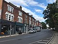
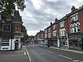
Sundridge Park, also known simply as Sundridge, [1] is an area of Greater London within the London Borough of Bromley and prior to 1965 it was in the historic county of Kent. It is situated north of Bromley, north-west of Widmore and Bickley, south of Grove Park and south-east of Downham. In the twentieth century Sundridge names began to overlap somewhat with neighbouring Plaistow, for example, the main Sundridge shopping parade by the station sits directly east of Plaistow Green, with business and facilities in the area using the two names interchangeably, and Plaistow Cemetery is actually on the Sundridge side of the border. However, during the early twenty first century there have been deliberate attempts to re-establish the separate identities of both villages, Sundridge has its own village sign, and representation has been made to the local council for a village sign for Plaistow. Plaistow refers especially to the area north of Sundridge Park station along Burnt Ash Lane, part of the A2212 road which runs north to south between Grove Park and Bromley.

Contents

History

Originally known as 'Sundresse', it is first mentioned in a charter of 987. [1] In the middle ages the land was owned by the Le Blund family. [1] In the early 1700s a large house was built on the site of Sundridge Park Manor; it was purchased and demolished by Sir Claude Scott in 1795, and the current building built in its place set in parkland. [1]

Sundridge Park mansion

Sundridge Park Manor is a Grade I listed mansion that was designed by John Nash and built by Samuel Wyatt. [1] It has been used as a management and conference centre but is to be split into luxury apartments, a process that was underway as of March 2020. [2] [1] Much of the mansion's former grounds now forms Sundridge Park Golf Club. [1]

Transport

Rail

Sundridge Park railway station, provides the area with National Rail shuttle services to Bromley North and Grove Park where connections can be made for services to London Charing Cross and London Cannon Street via Lewisham as well as to Orpington and Sevenoaks.

Buses

Sundridge is served by four London Buses routes

Notable residents

Related Research Articles

Elmstead is a residential district in south-east London, England, within the London Borough of Bromley. It is located north-east of Bromley.

<span class="mw-page-title-main">Keston</span> Human settlement in England

Keston is a village in Greater London, England, located within the London Borough of Bromley, Greater London. Prior to 1965 it was within the historic county of Kent. It is part suburban, part rural in nature and lies on the edge of Hayes Common, just beyond the London conurbation to the south of Bromley Common. It includes the small hamlet of Nash to the southwest. The northern, more suburban part of Keston is sometimes referred to as Keston Mark.

<span class="mw-page-title-main">Mottingham</span> Area of south-east London

Mottingham is a district of south-east London, England, which straddles the border of both the London Borough of Bromley and the Royal Borough of Greenwich. It is located south west of Eltham, 1.5 miles. It was historically within the county of Kent.

<span class="mw-page-title-main">Bromley and Chislehurst (UK Parliament constituency)</span> Parliamentary constituency in the United Kingdom, 1997 onwards

Bromley and Chislehurst is a constituency represented in the House of Commons of the Parliament of the United Kingdom since 2006 by Bob Neill, a Conservative.

<span class="mw-page-title-main">Lewisham</span> Area of London

Lewisham is an area of southeast London, England, six miles south of Charing Cross. It is the principal area of the London Borough of Lewisham, and was within the historic county of Kent until 1889. It is identified in the London Plan as one of 35 major centres in Greater London, with a large shopping centre and street market. Lewisham had a population of 60,573 in 2011.

<span class="mw-page-title-main">Bromley</span> Area of south east London

Bromley is a large town in South East Greater London, England, within the London Borough of Bromley. It is 9+12 miles southeast of Charing Cross, and had an estimated population of 88,000 as of 2023.

<span class="mw-page-title-main">Lee, London</span> Human settlement in England

Lee, also known as Lee Green, is an area of South East London, England, straddling the border of the London Borough of Lewisham and the Royal Borough of Greenwich. It is located northwest of Eltham and southeast of Lewisham. Historically it has been part of the historic county of Kent.

<span class="mw-page-title-main">River Ravensbourne</span> Right-bank tributary of the Thames in London

The River Ravensbourne is a tributary of the River Thames in south London, England. It flows into the tidal River Thames at Deptford, where its tidal reach is known as Deptford Creek.

<span class="mw-page-title-main">Downham, London</span> District of south-east London, England

Downham is a district of South East London, England, primarily within the London Borough of Lewisham and some parts in the London Borough of Bromley. It is located north of Bromley and south of Catford.

<span class="mw-page-title-main">River Quaggy</span> River in Greater London, England

The River Quaggy is a river, 17 kilometres (11 mi) in length, passing through the south-east London boroughs of Bromley, Greenwich and Lewisham. In its lower reaches it is an urban river, in its upper reaches further from London it is more natural and known as the Kyd Brook. The river rises from two sources near Princess Royal University Hospital (PRUH) at Locksbottom and is a tributary of the River Ravensbourne which it flows into near Lewisham station in Lewisham.

<span class="mw-page-title-main">Grove Park, Lewisham</span> Human settlement in England

Grove Park is a district of South East London, England within the London Borough of Lewisham. It is located north east of Bromley and south east of Lewisham.

<span class="mw-page-title-main">New Eltham</span> Human settlement in England

New Eltham is a suburban area of South East London, England, primarily in the Royal Borough of Greenwich with some parts in the London Borough of Bexley. It is located south east of Eltham and north west of Sidcup.

<span class="mw-page-title-main">Grove Park railway station</span> National Rail station in London, England

Grove Park is a railway station in southeast London, England. It is located on Baring Road within Travelcard Zone 4, and serves the areas of Grove Park and Downham in the London Borough of Lewisham. It is 8 miles 78 chains (14.4 km) down the line from London Charing Cross.

<span class="mw-page-title-main">Hither Green railway station</span> National Rail station in London, England

Hither Green is a railway station located in Hither Green in the London Borough of Lewisham, south-east London. It is 7 miles 16 chains (11.6 km) down the line from London Charing Cross and is situated between Lewisham and either Grove Park or Lee depending on the route.

<span class="mw-page-title-main">Sundridge Park railway station</span> National Rail station in London, England

Sundridge Park railway station serves Sundridge and Plaistow in the London Borough of Bromley in Greater London, in Travelcard Zone 4. It is 10 miles 12 chains (16.3 km) down the line from Charing Cross.

<span class="mw-page-title-main">St Mary Cray</span> Human settlement in England

St Mary Cray is an area of South East London, England, within the London Borough of Bromley. Historically it was a market town in the county of Kent. It is located north of Orpington, and 13 miles (21 km) south-east of Charing Cross.

<span class="mw-page-title-main">Locksbottom</span> Suburb of Greater London, England

Locksbottom is a suburb of south-east London within the London Borough of Bromley, Greater London. Prior to 1965 it was within the historic county of Kent. It is located south of Bromley Common, west of Crofton, north-west of Farnborough, and east of Keston.

Plaistow is an area of south-east London located in the London Borough of Bromley and, until 1965, in the historic county of Kent. It is located south of Downham and Grove Park and north of Sundridge Park and Bromley. Nowadays Plaistow overlaps somewhat with Sundridge, for example the main Sundridge Park shopping parade by the station sits directly east of Plaistow Green, with business and facilities in the area using the two names interchangeably. Plaistow now refers especially to the area north of Sundridge Park station along Burnt Ash Lane, part of the A2212 road which runs north to south between Grove Park and Bromley.

Widmore is an area of Greater London, within the London Borough of Bromley. It is located south-east of Sundridge, west of Bickley, north of Bromley Common, and east of Bromley.

References

  1. 1 2 3 4 5 6 7 8 9 Willey, Russ (2006). The London Gazetteer. Chambers Harrap Publishers Ltd. pp. 482–3.
  2. Six magnificent apartments for sale in stately homes across Britain
  3. "London Gardens Online, St Mary's Churchyard, Plaistow". London Parks and Gardens Trust. Retrieved 31 August 2020.