The estate of Gut-tres or Goodtrees was the family home of James Stewart but it was renamed Moredun House in 1769 by the new owner, David Stuart Moncrieff, in recognition of a hill on his Perthshire estate.[3] The house was acquired in 1923 to convert into a convalescent home for ex-servicemen. It was instead found unsuitable and demolished. The facility was instead created in the form of the Murray Homes for the Scottish Veterans Association in 1929. Part of the estate was also sold in 1924 to create the Moredun Research Institute.[4]
In the late 1960s six tower blocks were built in the area; whilst all six remain standing, a large project was undertaken to refurbish them to coincide with the construction of the new Edinburgh Royal Infirmary nearby. Two of the 16-storey blocks – Moncreiffe House and Forteviot House – are within the geographical boundary of Moredun, while the other four are technically in neighbouring Craigour.[5][6]
Moredun contains two clusters of shops on Moredun Park Road as well as a library and a primary school. It has transport links on a par with other similar areas of the city, with the Lothian Buses service 8 and Edinburgh City Council chartered Lothian and First East Lothian 18 passing through the area, with the 3, 7 and 29 services running nearby.
Craigour
Castleview House, one of four tower blocks in the area
For such a small area, Craigour consists of a wide variety of house types.[8] Some prefabs built in the 1950s still exist; however, most of these have been replaced by newer and permanent housing. There is 1980s private housing in a band immediately next to the A7, as well as council housing in the form of maisonettes plus four high-rise (16-storey) blocks[9] (Castleview House, Little France House, Marytree House and Moredun House).[10][11] Along the A7 road which passes Craigour to the east, are Victorian and pre-Victorian houses, in the form of the Little France and Pentecox clusters of houses.
Craigour has a nearby primary school[12] (technically just outwith its boundaries between Moredun and Fernieside), a pub (close to the Royal Infirmary just across the main road), a corner shop and bookmaker adjacent to one another.
This page lists residential areas of Edinburgh situated in the Edinburgh (settlement) urban area. The urban area of Edinburgh, the capital of Scotland, is located in the City of Edinburgh council area and in East Lothian. The City of Edinburgh council area is divided into wards areas that are combined into four operational management areas termed "localities":
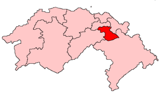
Edinburgh South was a constituency of the Scottish Parliament (Holyrood). It elected one Member of the Scottish Parliament (MSP) by the plurality method of election. Also, however, it was one of nine constituencies in the Lothians electoral region, which elected seven additional members, in addition to nine constituency MSPs, to produce a form of proportional representation for the region as a whole.
Sighthill is a suburb in the west of Edinburgh, Scotland. The area is bordered by Broomhouse and Parkhead to the east, South Gyle to the north, the industrial suburb of Bankhead and the Calders neighbourhood to the west, and Wester Hailes to the south. It is sometimes included in the Wester Hailes area, while the Calders, Bankhead and Parkhead are sometimes considered parts of Sighthill. Administratively it has formed a core part of the City of Edinburgh Council's Sighthill/Gorgie ward since 2007.
Cameron Toll is a suburb located to the south of Edinburgh, Scotland. Originally it was the site of a toll house built in the early 19th century, which was located on a stretch of road between Edinburgh and Dalkeith. Today the area is home to Cameron Toll Shopping Centre, which opened in 1984. The meaning of the name Cameron is suggested to be 'crooked hill', derived from the Scots Gaelic 'cam', crooked, and Old Irish 'brun' meaning hill, believed to refer to Arthur's Seat clearly visible nearby; the original name may have been Pictish. There are a few small housing estates to the east of the area.
Mortonhall is an area of Edinburgh, Scotland, on the south edge of the city.
The Calders is a residential neighbourhood in Edinburgh, Scotland – not to be confused with the Calders of West Lothian aka West Calder, Mid Calder and East Calder, three separate villages. It is sometimes considered to be part of Wester Hailes or Sighthill, larger developments to its south and east respectively. From 2007 to 2017, it fell within the Sighthill/Gorgie multi-member ward of the City of Edinburgh Council administration along with Sighthill, but following a boundary change has been in the Pentland Hills ward since then, along with Wester Hailes.
Ferniehill is a residential neighbourhood of Edinburgh, the capital of Scotland. Primarily a low-density 1960s council estate with two small public parks, it is situated in the south-east of the city, lying immediately south of the slightly older Fernieside neighbourhood, east of Moredun, and to the north of Gilmerton's main street, where most local amenities are located. The Drum country estate and some farmland separates it from the village of Danderhall outside the city boundary.
Gilmerton is a suburb of Edinburgh, about 4 miles (6.4 km) southeast of the city centre.
Greendykes is a neighbourhood of Edinburgh, the capital of Scotland. It was originally a council scheme, consisting mostly of low-rise flats but also two 15-storey tower blocks. It is sometimes considered to be part of Craigmillar; areas such as Niddrie, Niddrie Mains and Newcraighall are also situated nearby.
Little France is a suburb of Edinburgh, the capital of Scotland. It is on the A7, approximately 4 miles (6.4 km) south of the city centre.
Stenhouse is a suburb of Edinburgh, the capital of Scotland. It lies to the west of the City Centre, adjacent to Whitson and Saughton Mains and close to Broomhouse and Chesser. It is a mainly residential area.
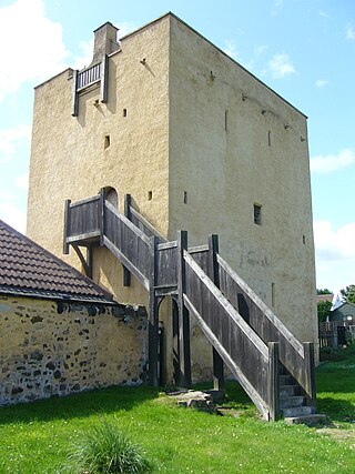
Liberton Tower is a four-storey, square-plan tower house in the Edinburgh suburb of Liberton, on the east side of the Braid Hills.
Dumbiedykes is a residential area in the centre of Edinburgh, Scotland. It mainly comprises public housing developments.
Glasgow, the largest city in Scotland, has several distinct styles of residential buildings. Building styles reflect historical trends, such as rapid population growth in the 18th and 19th centuries, deindustrialisation and growing poverty in the late 20th century, and civic rebound in the 21st century.
The Edinburgh Science Triangle (EST) is a multi-disciplinary partnership between universities, research institutes, the National Health Service, science parks, the national economic development agency Scottish Enterprise, and central and local government in Edinburgh and neighbouring council areas. The three points of the "triangle" are Livingston in West Lothian, Musselburgh in East Lothian, and the Easter Bush campus in Midlothian.
Inch House, a former country house situated within Inch Park in Edinburgh, Scotland, is a category A listed building. The oldest part, a Scottish vernacular L-plan tower house, dates from the early 17th century. From 1660 it was owned by the Gilmour family, who arranged for additions and extensions to the house in the 18th and 19th centuries. It was sold to the then Edinburgh Corporation in 1945. Since then it has been used as a primary school and more recently as a community centre.
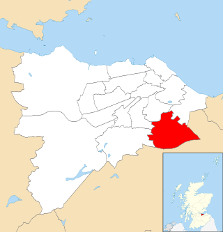
Liberton/Gilmerton is one of the seventeen wards used to elect members of the City of Edinburgh Council. Established in 2007 along with the other wards, it elects four Councillors.
Gracemount is a neighbourhood in the south of Edinburgh, Scotland, bordering Alnwickhill and Kaimes to the west, Liberton to the north, Gilmerton to the east and Southhouse to the south.
This page is based on this Wikipedia article Text is available under the CC BY-SA 4.0 license; additional terms may apply. Images, videos and audio are available under their respective licenses.