The Inch, Edinburgh

Last updated

The Inch
The Inch - geograph.org.uk - 10314.jpg
Examples of Inch housing
Edinburgh UK location map.svg
Red pog.svg
The Inch
Location within the City of Edinburgh council area
Scotland location map.svg
Red pog.svg
The Inch
Location within Scotland
OS grid reference NT279704
Council area
Lieutenancy area
Country Scotland
Sovereign state United Kingdom
Post town Edinburgh
Postcode district EH16
Dialling code 0131
Police Scotland
Fire Scottish
Ambulance Scottish
UK Parliament
Scottish Parliament
List of places
UK
Scotland
55°55′19″N3°09′14″W / 55.922°N 3.154°W / 55.922; -3.154

The Inch is a district of Edinburgh, Scotland, located to the south of Inch Park in the south of the city. [1] It is located 2 miles (3 km) south south-east of central Edinburgh. [2] It incorporates the Inch housing development, Inch Park and the category A listed Inch House, a former country house now used as a community centre. The associated Inch Doocot or dovecot, also a category A listed building, is situated close by, west of Gilmerton Road.

Contents

Etymology

The word "Inch" derives from the Scots Gaelic innis which can mean either "island" or a dry area within marshland or a river meadow. [3] [4] This suggests that the land on which it stands was originally dry land in the flood plain of the nearby Braid Burn. [5]

The Inch housing development

The housing development is bounded by Old Dalkeith Road to the east, Liberton Road to the west, Kingston Avenue to the south and Glenallan Drive and Inch Park to the north. [1]

The housing development began in 1949. The City of Edinburgh Council had departed from the usual practice of using in-house architects for the design and arranged for a competition open to private firms of architects. The judges were George Macniven, formerly chief architect at the Department of Health for Scotland [6] assisted by the City Architect, Ebenezer MacRae, and Lady Gilmour, a previous resident of the adjacent Inch House. Sixty eight designs were considered and David Stratton Davis of the family firm Stratton Davis & Yates based in Gloucester, England was judged the winner. [7] He was 29 years old. [8]

Stratton based his design on Garden City guidelines, popular at the time. This envisaged a self contained community adjacent to large green spaces, in this case Inch Park. As well as preserving as many existing trees as possible many new trees were planted. Vistas were also important in the design so that from the site there are views to the east of Craigmillar Castle and to the south and west views of Blackford Hill and the Pentland Hills. The design included local amenities like schools and churches and shops. [7]

Housing was designed to accommodate families, older people and single people and so contained houses of differing sizes and small flatted-blocks. All housing was low rise. Roofs were finished with slate, pantiles or copper, and the walls were rendered to give a cream finish. Flats were to account for no more than 10% of the housing and each house was to have a garden and drying area, with houses at least 20 feet (6.1 m) back from the pavement. [8] By 1953 the houses were all occupied. [8]

In 1955 the Saltire Society considered it to be "the best designed local authority housing in Scotland" and presented an award. Many houses in the estate have now passed into private ownership. [7]

Many of the streets are named for characters and places in the novels and poems of Sir Walter Scott. [9] A later development to the north-west has street names associated with the poet Robert Burns. [1]

A parade of shops was built on the main thoroughfare Walter Scott Avenue. The primary schools serving the area are Liberton Primary School and St. John Vianney Roman Catholic Primary School. [1]

A pillar box placed in November 1952 on Gilmerton Road was the first in Scotland to carry the insignia E II R. There was opposition to this on the grounds that Queen Elizabeth was the first of that name to rule over Scotland. The pillar box became the target of attacks and was destroyed by a gelignite bomb on 12 February 1953. The replacement pillar box carried an image of the Crown of Scotland. [10]

Inch House

Inch House in Edinburgh Inch House in Edinburgh.jpg
Inch House in Edinburgh

The area grew around Inch House, a Scottish vernacular tower house dating from 1617. It is a category A listed building. [11]

The house was sold to the City of Edinburgh Council in 1946 and served as a primary school before the building was turned into a community centre. [2]

The Ravenswood standing stone, Ravenswood Avenue, at the Inch. Standing Stone, at the Inch Edinburgh.jpg
The Ravenswood standing stone, Ravenswood Avenue, at the Inch.

Inch Park

Inch Park sports pitches with Arthur's Seat in the background Inch Park, Edinburgh;sports pitches.jpg
Inch Park sports pitches with Arthur's Seat in the background

Inch Park was formerly the estate around Inch House. It is now a public park which incorporates sports pitches, used for rugby and football in winter and cricket in summer. There is a children's play area to the south of the park. It is bounded on the north east by Old Dalkeith Road (A7) and on the northwest by Gilmerton Road (A772). [7] The Braid Burn, which runs west to east within the northern boundary was the subject of a flood prevention scheme begun in 2010. [13] Ownership passed from the Gilmour family to the City of Edinburgh Council in 1946. In 2009 Inch Park Community Sports Club took over the management of the park from the city Council. The Sports club is a charity registered in Scotland ( SC040057), formed to provide sporting and leisure activities for local sports clubs and the local community. Integral to the plan was the partnership between three sports clubs based at the park, Lismore Rugby Football Club, Edinburgh South Community Football Club and Edinburgh South Cricket Club. [14]

The community Sports Club was given an 80-year lease to manage the park. They received initial financial support from the City of Edinburgh Council, The Robertson Trus t, Sportscotland and from the Scottish Landfill Communities Fund administered by WREN. [15]

The sports facilities include two rugby pitches, two football pitches and a cricket oval. There is a sports pavilion which has changing accommodation, licensed bar, kitchen and meeting room. The Sports Club was given recognition as a Community Sports Hub by Sportscotland, the first such in Scotland. [16]

The club is governed by a board of trustees. [14]

Edinburgh South Cricket Club

The cricket club has 3 men's teams in the East of Scotland Cricket Association league. [17]

In addition there is a Sunday team, the Edinburgh South Mitres, which play friendly matches. There is also a women's and girls section. [17]

Edinburgh South Community Football Club

The football club has been given the Scottish Football Association Quality Mark as an accredited Platinum Club. [18] It fields some 50 teams in various leagues and stages, involving around 650 players and around 125 volunteer coaches and officials.

It provides a pathway for boys from soccer school up to senior football, previously in partnership with Whitehill Welfare [18] until 2020, when the club had their own adult team accepted into the East of Scotland Football League (initially to play at Dalkeith. [19] A community coach is establishing a similar pathway for girls. [18]

Lismore Rugby Football Club

The rugby union club was founded in 1901 and has played at Inch Park since the 1953/54 season. Previously it was based at various locations. It fields 2 men's teams and a women's team. [20]

It is a charity registered in Scotland (SC043329). [21]

Inch plant nursery

The Inch Nursery occupies a 10-acre site to the east of the park. It was formerly the walled garden of Inch House. Owned by the City of Edinburgh Council, it is used to grow most of the plants for the city's municipal gardens and green spaces. It is a training centre for horticulture [22] and operates a shop that sells plants to the public [23]

The Inch Doocot Nether Liberton Doocot - geograph.org.uk - 174934.jpg
The Inch Doocot

Inch Doocot

This is the largest remaining doocot (or dovecot) in Edinburgh. It is sited on Gilmerton Road and is a category A listed building. Dating from the 17th century, it has 2 chambers built of sandstone, each with a boarded door and 16 flight holes. Above the chambers is a rat course, designed to stop rats climbing in. The roof is finished with pantiles. It is estimated that there are around 2000 stone nesting boxes. [24]

Related Research Articles

<span class="mw-page-title-main">Midlothian</span> Council area of Scotland

Midlothian is a historic county, registration county, lieutenancy area and one of 32 council areas of Scotland used for local government. Midlothian lies in the east-central Lowlands, bordering the City of Edinburgh council area, East Lothian and the Scottish Borders.

<span class="mw-page-title-main">Dalkeith</span> Human settlement in Scotland

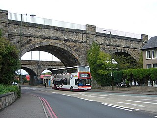
Dalkeith is a town in Midlothian, Scotland, on the River Esk. It was granted a burgh of barony in 1401 and a burgh of regality in 1540. The settlement of Dalkeith grew southwestwards from its 12th-century castle . Dalkeith has a population of 12,342 people according to the 2011 census.

<span class="mw-page-title-main">Edinburgh City Bypass</span> Road in Scotland

The Edinburgh City Bypass, designated as A720, is one of the most important trunk roads in Scotland. Circling around the south of Edinburgh, as the equivalent of a ring road for the coastal city, it links together the A1 towards north-east England, the A702 towards north-west England, the M8 through the Central Belt towards Glasgow, the A7 through south-east Scotland and north-west England as well as the A8 leading to the M9 for Stirling and the Queensferry Crossing.

<span class="mw-page-title-main">Toryglen</span> Human settlement in Scotland

Toryglen is a district in southern Glasgow, Scotland, falling within the Langside ward under Glasgow City Council. It is approximately two miles south of the city centre, bounded to the west by Mount Florida, the north-west by Polmadie, to the north-east by the West Coast Main Line railway and the M74 motorway the south by King's Park, and immediately to the east by the town of Rutherglen.

<span class="mw-page-title-main">Newington, Edinburgh</span> Human settlement in Scotland

Newington is a neighbourhood of southern Edinburgh, Scotland. Developed from the early 19th century, it is an affluent, predominantly residential area.

<span class="mw-page-title-main">Inverleith</span> Human settlement in Scotland

Inverleith is an inner suburb in the north of Edinburgh, Scotland, on the fringes of the central region of the city. Its neighbours include Trinity to the north and the New Town to the south, with Canonmills at the south-east and Stockbridge at the south-west.

Sighthill is a suburb in the west of Edinburgh, Scotland. The area is bordered by Broomhouse and Parkhead to the east, South Gyle to the north, the industrial suburb of Bankhead and the Calders neighbourhood to the west, and Wester Hailes to the south. It is sometimes included in the Wester Hailes area, while the Calders, Bankhead and Parkhead are sometimes considered parts of Sighthill. Administratively it has formed a core part of the City of Edinburgh Council's Sighthill/Gorgie ward since 2007.

<span class="mw-page-title-main">Cameron Toll</span> Suburb in the South of Edinburgh

Cameron Toll is a suburb located to the south of Edinburgh, Scotland. Originally it was the site of a toll house built in the early 19th century, which was located on a stretch of road between Edinburgh and Dalkeith. Today the area is home to Cameron Toll Shopping Centre, which opened in 1984. The meaning of the name Cameron is suggested to be 'crooked hill', derived from the Scots Gaelic 'cam', crooked, and Old Irish 'brun' meaning hill, believed to refer to Arthur's Seat clearly visible nearby; the original name may have been Pictish. There are a few small housing estates to the east of the area.

<span class="mw-page-title-main">Longstone, Edinburgh</span> Human settlement in Scotland

Longstone is a suburb of Edinburgh in Scotland. The area is primarily residential in nature, although the area includes several small shops, eateries and supermarkets, as well as one of the main bus depots for the city's buses. The population of Longstone was 4,678 in 2019.

Fernieside is a neighbourhood on the southern edge of the city of Edinburgh, Scotland, four miles (6.5 km) southeast of the city centre. It is very close to Craigour, which is just to its north, with Ferniehill to the south, Moredun to the west and open land to the east denoting the city boundary ; most amenities are found at Gilmerton. Laid out as public housing from 1947, many properties have been sold through right-to-buy legislation, while small private developments have been inserted to the north in the early 21st century.

<span class="mw-page-title-main">Gilmerton</span> Human settlement in Scotland

Gilmerton is a suburb of Edinburgh, about 4 miles (6.4 km) southeast of the city centre.

<span class="mw-page-title-main">Liberton, Edinburgh</span> Human settlement in Scotland

Liberton is a suburb of Edinburgh, the capital of Scotland. It is in the south of the city, south of The Inch, east of the Braid Hills and west of Moredun.

<span class="mw-page-title-main">Dumbiedykes</span>

Dumbiedykes is a residential area in the centre of Edinburgh, Scotland. It mainly comprises public housing developments.

<span class="mw-page-title-main">A772 road</span> Road in Edinburgh

The A772 was a major A road located in Edinburgh, Scotland. The A772 was originally the A7 before a major renumbering of the roads into Edinburgh and also begins there, at a junction with the A701 in the neighbourhood of Nether Liberton. From this junction, the A772 heads south-east through Gilmerton, a suburb of Edinburgh. This part is known as Gilmerton Road and has a 30 mph speed limit. At the edge of Gilmerton, the road becomes Drum Street, where it passes The Drum, an 18th-century country house, before reverting to Gilmerton Road.

<span class="mw-page-title-main">Lochend Park</span> Park in Edinburgh, Scotland

Lochend Park is a public park in Edinburgh, Scotland. It is situated in the Lochend / Restalrig area, next to Lochend Castle and near Meadowbank Stadium. The loch with its wide range of waterfowl is the main attraction, but there are also historical buildings, a children's play area, and sports areas. The park was awarded a Green Flag in 2012 in recognition of it being a quality greenspace. Within the park there is a 16th-century doocot which is Category B listed.

<span class="mw-page-title-main">Westburn, South Lanarkshire</span> Human settlement in Scotland

Westburn is a district of the town of Cambuslang in South Lanarkshire, Scotland. It was formerly home to a steel works and power station which were the area's major employers; the sites are now occupied by a housing development and modern industrial estate respectively. Administratively, Westburn is within the Cambuslang East ward of the South Lanarkshire Council area and has a population of around 2,000.

<span class="mw-page-title-main">Inch House, Edinburgh</span> Building in Edinburgh

Inch House, a former country house situated within Inch Park in Edinburgh, Scotland is a category A listed building. The oldest part, a Scottish vernacular L-plan tower house, dates from the early 17th century. From 1660 it was owned by the Gilmour family, who arranged for additions and extensions to the house in the 18th and 19th centuries. It was sold to the then Edinburgh Corporation in 1945. Since then it has been used as a primary school and more recently as a community centre.

<span class="mw-page-title-main">Liberton/Gilmerton (ward)</span>

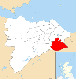
Liberton/Gilmerton is one of the seventeen wards used to elect members of the City of Edinburgh Council. Established in 2007 along with the other wards, it elects four Councillors.

<span class="mw-page-title-main">Edinburgh South C.F.C.</span> Football club

Edinburgh South Community Football Club is a Scottish football club based in the Inch district of south-eastern Edinburgh. Formed as a youth club in the 1960s, they successfully applied to have a senior team enter the East of Scotland Football League for the 2020–21 season as Edinburgh South FC.

<span class="mw-page-title-main">St Leonard's, Edinburgh</span> Human settlement in Scotland

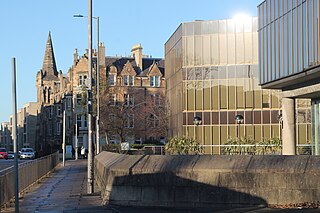
St Leonard's is a neighbourhood of south-central Edinburgh, Scotland, United Kingdom. Once notable as a centre of industry, it is now primarily residential.

References

  1. 1 2 3 4 "The Inch from The Gazetteer for Scotland". www.scottish-places.info. Retrieved 24 April 2019.
  2. 1 2 "Inch House". The Gazetteer for Scotland. Retrieved 13 August 2017.
  3. "innis - Scottish Gaelic-English Dictionary". Glosbe. Retrieved 19 April 2019.
  4. "Gaelic Place-Names: 'Eilean' and 'Innis'". The Bottle Imp. 1 November 2012. Retrieved 5 May 2019.
  5. Old Edinburgh Club (1917). The book of the Old Edinburgh Club. Edinburgh : The Old Edinburgh Club. pp.  3.
  6. "Dictionary of Scottish Architects - DSA Architect Biography Report". www.scottisharchitects.org.uk. Retrieved 29 April 2019.
  7. 1 2 3 4 The City of Edinburgh Council. "Gardens and Designed Landscapes site reports | The City of Edinburgh Council". www.edinburgh.gov.uk. Retrieved 24 April 2019.
  8. 1 2 3 Cook, Bill (2017). The Inch. Edinburgh's first Garden City. Inch House Community Management Committee. p. 16.
  9. Harris, Stuart (2002). The Place Names of Edinburgh. London: Steve Savage Publishers Ltd. pp. 323–324. ISBN   1-904246-06-0.
  10. "Lost Edinburgh: the Queen and the exploding post box". www.scotsman.com. Retrieved 24 April 2019.
  11. "Inch House - A Brief History - South Edinburgh Net :: South Edinburgh's Community Network". www.southedinburgh.net. Retrieved 24 April 2019.
  12. Edinburgh: The Buildings of Scotland (Penguin Books, 1984), p. 27.
  13. "Braid Burn at Inch Park, Edinburgh, Scotland" (PDF). therrc.co.uk. 2010.
  14. 1 2 "Home". Inch Park Community Sports Club. Retrieved 28 April 2019.
  15. "Welcome to WREN — WREN". www.wren.org.uk. Retrieved 28 April 2019.
  16. "What is a community sport hub?". sportscotland.org.uk. Retrieved 28 April 2019.
  17. 1 2 "Edinburgh South Cricket Club". www.edinburghsouthcc.org. Retrieved 28 April 2019.
  18. 1 2 3 "Edinburgh South Community Football Club". Edinburgh South Community FC. Retrieved 28 April 2019.
  19. Edinburgh South seek a manager after joining East of Scotland League, Edinburgh Evening News, 1 May 2020
  20. "Lismore Rugby Football Club". www.pitchero.com. Retrieved 28 April 2019.
  21. "Lismore RFC". 12 April 2009. Archived from the original on 12 April 2009. Retrieved 28 April 2019.
  22. The City of Edinburgh Council. "Inch Plant Nursery". www.edinburgh.gov.uk. Retrieved 6 May 2019.
  23. "Inch Plant Nursery". Edinburgh Outdoors. City of Edinburgh Council. Retrieved 7 October 2023.
  24. "Inch Doocot, Gilmerton Road, Edinburgh (LB28140)". portal.historicenvironment.scot. Retrieved 24 April 2019.