Corstorphine is a village and parish to the west of Edinburgh, now considered a suburb of that city.
Silverknowes is a district of Edinburgh, Scotland. Silverknowes lies to the northwest of the city. The district contains over 2000 homes, ranging in size from bungalow to semi-detached housing, much of it built during the mid-twentieth century.

Davidson's Mains is a former village and now a district in the north-west of Edinburgh, Scotland. It is adjacent to the districts of Barnton, Cramond, Silverknowes, Blackhall and Corbiehill/House O'Hill. It was absorbed into Edinburgh as part of the boundary changes in 1920 and is part of the EH4 postcode area.

Barnton is a suburb of Edinburgh, Scotland, located in the north-west of the city, between Cramond and Corstorphine Hill and west of Davidsons Mains. Part of the area was traditionally known as "Cramond Muir" in reference to Cramond to the north.

Abbeyhill is an area of Edinburgh, the capital of Scotland.

Sighthill is a suburb in the west of Edinburgh, Scotland.
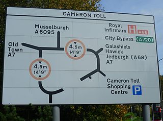
Cameron Toll is a suburb located to the south of Edinburgh, Scotland. Originally it was the site of a toll house built in the early 19th century, which was located on a stretch of road between Edinburgh and Dalkeith. The meaning of the name Cameron is suggested to be 'crooked hill', derived from the Scots Gaelic 'cam', crooked, and Old Gaelic 'brun' meaning hill, believed to refer to Arthur’s Seat clearly visible nearby; the original name may have been Pictish.
Longstone is a suburb of Edinburgh in Scotland.

East Craigs is a residential district of Edinburgh located in the north-west of the city, on the western flanks of Corstorphine Hill. It lies next to the green belt, and prior to development was a working farm.

Craigcrook is a suburb of Edinburgh, Scotland, best known for Craigcrook Castle. It is fairly affluent, and lies on the north east slopes of Corstorphine Hill. It is near Clerwood, and Blackhall. Davidson's Mains lies to the north, separated from the district by the A90 - Queensferry Road.
Goldenacre is an area in Edinburgh, Scotland, lying on and to the south of the Ferry Road, and south of Trinity.

Corstorphine Hill is a low ridge-shaped hill rising above the western suburbs of Edinburgh, Scotland. Although there has been residential and commercial development on its lower slopes, especially in the south and west, most of the hill is occupied by a local nature reserve, consisting of extensive broadleaf woodland, and is accessible to the public. The hill, which is composed largely of dolerite, was formed by the west-to-east movement of glaciers during the Pleistocene period. There is evidence of prehistoric settlement. Today the hill is popular with walkers, dog-walkers and joggers. Among its interesting features are a 19th-Century tower, a walled garden and a Cold War bunker.

Drumbrae or Drum Brae is the name of a suburb of west Edinburgh, Scotland generally considered to be part of the neighbouring larger areas of Corstorphine and Clermiston. This is a commuter settlement as many people who live in the area travel to the centre of town to attend work.

The Gyle Shopping Centre is located in the South Gyle area of Edinburgh, Scotland. The main centre has two anchor tenants, Marks & Spencer and Morrisons, at opposite ends of the shopping centre.
Bughtlin is a suburb of Edinburgh, the capital of Scotland. It is east of the A902.

Clermiston is a suburb of Edinburgh, Scotland, to the west of the city and to the immediate north of Corstorphine, on the western slopes of Corstorphine Hill. Clermiston estate, built in 1954, was part of a major 1950s house-building programme to tackle overcrowding in Leith and Gorgie. The area is now home to more than 20,000 people, and abuts onto Drumbrae, Clerwood and Corstorphine.
Ravelston is an affluent area of Edinburgh, Scotland, to the west of the city centre, the east of Corstorphine and Clermiston, the north of Murrayfield and Roseburn and to the south of Queensferry Road. Ravelston is often considered to be part of the larger neighbouring area of Murrayfield.
Carrick Knowe is a suburb in the west of Edinburgh in Scotland, located approximately 3 miles from the city centre. It is bordered by Tyler's Acre to the north, the Glasgow/Aberdeen railway line to the south, Carrick Knowe Golf Course to the east, and Saughton Road North to the west. The catchment area for the primary school encompasses this entire area. It is often considered part of Corstorphine, however it has its own shopping areas, primary school, parish church and public park.

Barnton Quarry is a disused stone quarry in Corstorphine Hill, Clermiston, Edinburgh, Scotland. The site was later used as a military command centre, and is now being converted into a museum.
The Potterrow Mandela Centre or Potterrow Student Centre is a students' union building in Edinburgh, Scotland.
