
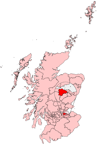
Midlothian is a historic county, registration county, lieutenancy area and one of 32 council areas of Scotland used for local government. Midlothian lies in the east-central Lowlands, bordering the City of Edinburgh council area, East Lothian and the Scottish Borders.
Edinburgh West is a burgh constituency of the House of Commons of the Parliament of the United Kingdom, first contested at the 1885 general election.

Edinburgh West was a constituency of the Scottish Parliament (Holyrood) from 1999 until 2011. It elected one Member of the Scottish Parliament (MSP) by the plurality method of election. It was also one of nine constituencies in the Lothians electoral region, which elected seven additional members, in addition to nine constituency MSPs, to produce a form of proportional representation for the region as a whole.
Corstorphine is an area of the Scottish capital city of Edinburgh. Formerly a separate village and parish to the west of Edinburgh, it is now a suburb of the city, having been formally incorporated into it in 1920.
Silverknowes is a district of Edinburgh, Scotland. Silverknowes lies to the northwest of the city. The district contains over 2000 homes, ranging in size from bungalow to semi-detached housing, much of it built during the mid-twentieth century.

Davidson's Mains is a former village and now a district in the north-west of Edinburgh, Scotland. It is adjacent to the districts of Barnton, Cramond, Silverknowes, Blackhall and Corbiehill/House O'Hill. It was absorbed into Edinburgh as part of the boundary changes in 1920 and is part of the EH4 postcode area.

Barnton is a suburb of Edinburgh, Scotland, in the north-west of the city, between Cramond and Corstorphine Hill and west of Davidsons Mains. Part of the area was traditionally known as "Cramond Muir" in reference to Cramond to the north.

South Gyle is an area of Edinburgh, Scotland, lying on the western edge of the city and to the south and west of an area of former marshland once known as the Gogarloch, on the edge of Corstorphine. Most of the buildings in the area are of recent origin, dating from the later 1980s, 1990s, and early 21st century, with the exception of some farm workers' cottages and an early 1970s council estate abutting South Gyle railway station.

East Craigs is a residential district of Edinburgh located in the north-west of the city, on the western flanks of Corstorphine Hill. It lies next to what remains of the green belt, and prior to development was a working farm.
Gogarloch is a residential area within South Gyle, Edinburgh, Scotland. It lies near South Gyle railway station and South Gyle Broadway, 4+1⁄2 miles (7.2 km) west of the city centre. Corstorphine and Wester Broom are nearby.

Blackhall is a suburb in the north west of the Scottish capital city Edinburgh. It is a mainly residential area with amenities including a library and a small number of shops.

Corstorphine Hill is a low ridge-shaped hill rising above the western suburbs of Edinburgh, Scotland. Although there has been residential and commercial development on its lower slopes, especially in the south and west, most of the hill is occupied by a local nature reserve, consisting of extensive broadleaf woodland, accessible to the public.

Craigleith is an area of west Edinburgh, Scotland. Its name comes from various forms of Craig of Inverleith, or rock or hill of Inverleith. The area lies between Ravelston Dykes, to Crewe Toll and the Ferry Road, and Comely Bank on the east. Queensferry Road and Craigleith Road both pass through here. There are also a number of private schools in the area such as Stewart's Melville College and The Mary Erskine School.
Wester Broom is a district of Edinburgh, Scotland. It borders Broomhouse/Forrester, Corstorphine and South Gyle. It is sometimes considered to be part of one of the latter two. It is mainly residential, with a few small shops and a large Tesco nearby. The Fife railway line is arguably the boundary, although some will extend it south to the Glasgow line, and to include Forresters and two schools.

Clermiston is a suburb of Edinburgh, Scotland, to the west of the city and to the immediate north of Corstorphine, on the western slopes of Corstorphine Hill. Clermiston estate, built from 1954 onwards, was part of a major 1950s house-building programme to tackle overcrowding in Leith and Gorgie. The area is now home to more than 20,000 people, and abuts onto Drumbrae, Clerwood and Corstorphine.
Muirhouse is a housing estate in the north of Edinburgh, the capital of Scotland.
Parkgrove is a suburb of Edinburgh, the capital of Scotland. Approximately 4 miles north-west of Edinburgh city centre. The suburb is located between the neighbouring areas of Clermiston, Barnton and Davidson's Mains.
Ravelston is an area of Edinburgh, Scotland, to the west of the city centre, the east of Corstorphine and Clermiston, the north of Murrayfield, West End and Roseburn and to the south of Queensferry Road. Ravelston is often considered to be part of the larger neighbouring area of Murrayfield.
West Coates or Wester Coates is a residential district of central Edinburgh, the capital of Scotland. It is on the A8, in proximity to Haymarket railway station and Roseburn, west of the city centre, bounded by the Water of Leith on its north side.

